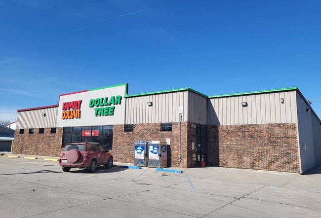
Property Record
109 E Clark St, La Plata, MO 63549

Current Lease Availabilities
NEARBY LISTINGS FOR SALE OR LEASE
-
-
View all La Plata listings for lease on LoopNet.com
Property Detail
109 E Clark St
060102-0308-02041-000800
Original Town Add La Plata
Storebuilding
55' E END 11 & 12, ALL 13, 14, 15, 16 & 40' E END 9 & 10, BLK 4
X
Macon
29121C0090C
Missouri
2024
11
2025
0.84 AC
960100
Missouri North Area
9,920 SF
Other Market Areas
DEMOGRAPHICS near 109 E Clark St
1 mile
3 mile
5 mile
2024 Total Population
1,410
1,654
2,045
2029 Population
1,413
1,658
2,055
Pop Growth 2024-2029
+ 0.21%
+ 0.24%
+ 0.49%
Average Age
43
43
43
2024 Total Households
616
708
850
HH Growth 2024-2029
+ 0.32%
+ 0.42%
+ 0.59%
Median Household Inc
$45,592
$46,097
$47,000
Avg Household Size
2.30
2.30
2.30
2024 Avg HH Vehicles
2.00
2.00
2.00
Median Home Value
$92,325
$95,324
$98,982
Median Year Built
1964
1965
1966
Nearby Places
Map Layers
Map Styles
 Street
 Aerial
Transit
 Traffic
 Biking
Places
Listings with unknown addresses are not visible on the map
- Restaurants
- Banks
- Shops
- Fitness
- Groceries
PUBLIC TRANSPORTATION
COMMUTER RAIL
La Plata Amtrak Station (Southwest Chief - Amtrak)
Drive
Walk
Distance
La Plata Amtrak Station (Southwest Chief - Amtrak)
2 min
13 min
0.7 mi
Freight Ports
Port Milwaukee
Drive
Walk
Distance
Port Milwaukee
495 min
427.1 mi
Nearby Properties
Address
Land Use
TOTAL SIZE
Lot Size
Zoning
Address
Land Use
TOTAL SIZE
Lot Size
Zoning
5,000 SF
1.97 AC
Address
Land Use
TOTAL SIZE
Lot Size
Zoning
5,120 SF
2.79 AC
Address
Land Use
TOTAL SIZE
Lot Size
Zoning
4,560 SF
0.32 AC
Address
Land Use
TOTAL SIZE
Lot Size
Zoning
3,520 SF
0.16 AC
Address
Land Use
TOTAL SIZE
Lot Size
Zoning
1,344 SF
7.19 AC
Address
Land Use
TOTAL SIZE
Lot Size
Zoning
16,885 SF
3.55 AC
Address
Land Use
TOTAL SIZE
Lot Size
Zoning
720 SF
38.60 AC
Address
Land Use
TOTAL SIZE
Lot Size
Zoning
2,160 SF
25 AC
Address
Land Use
TOTAL SIZE
Lot Size
Zoning
3,600 SF
0.35 AC
Address
Land Use
TOTAL SIZE
Lot Size
Zoning
9,230 SF
1.67 AC
Address
Land Use
TOTAL SIZE
Lot Size
Zoning
3,190 SF
0.84 AC
Address
Land Use
TOTAL SIZE
Lot Size
Zoning
17,883 SF
7.25 AC
Address
Land Use
TOTAL SIZE
Lot Size
Zoning
3,675 SF
0.44 AC
Address
Land Use
TOTAL SIZE
Lot Size
Zoning
1,920 SF
0.29 AC
Address
Land Use
TOTAL SIZE
Lot Size
Zoning
2,508 SF
1.03 AC
Address
Land Use
TOTAL SIZE
Lot Size
Zoning
2,160 SF
1.83 AC
Address
Land Use
TOTAL SIZE
Lot Size
Zoning
2,244 SF
0.32 AC
Address
Land Use
TOTAL SIZE
Lot Size
Zoning
9,920 SF
0.84 AC
Address
Land Use
TOTAL SIZE
Lot Size
Zoning
3,360 SF
1.92 AC
Address
Land Use
TOTAL SIZE
Lot Size
Zoning
1,560 SF
0.56 AC
Address
Land Use
TOTAL SIZE
Lot Size
Zoning
3,996 SF
1.52 AC
Address
Land Use
TOTAL SIZE
Lot Size
Zoning
1,200 SF
11.47 AC
Address
Land Use
TOTAL SIZE
Lot Size
Zoning
2,346 SF
0.12 AC
Address
Land Use
TOTAL SIZE
Lot Size
Zoning
11,440 SF
1.33 AC
Address
Land Use
TOTAL SIZE
Lot Size
Zoning
5,202 SF
57.70 AC
Address
Land Use
TOTAL SIZE
Lot Size
Zoning
2,304 SF
0.54 AC
Address
Land Use
TOTAL SIZE
Lot Size
Zoning
1,680 SF
0.22 AC
Address
Land Use
TOTAL SIZE
Lot Size
Zoning
2,695 SF
190.60 AC
Address
Land Use
TOTAL SIZE
Lot Size
Zoning
2,244 SF
5.41 AC
Address
Land Use
TOTAL SIZE
Lot Size
Zoning
8,064 SF
4.91 AC
The World's #1 Commercial Real Estate Marketplace
Connect with us
© 2026 CoStar Group
The information above has been obtained from sources believed reliable. While we do not doubt its accuracy we have not verified it and make no guarantee, warranty or representation about it. It is your responsibility to independently confirm its accuracy and completeness. Any projections, opinions, assumptions, or estimates used are for example only and do not represent the current or future performance of the property. The value of this transaction to you depends on tax and other factors which should be evaluated by your tax, financial, and legal advisors. You and your advisors should conduct a careful, independent investigation of the property to determine to your satisfaction the suitability of the property for your needs.