Property Record
109 E Division St, Sparta, MI 49345
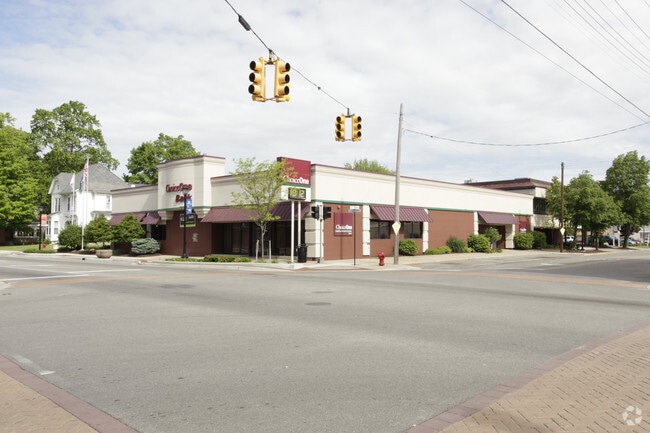

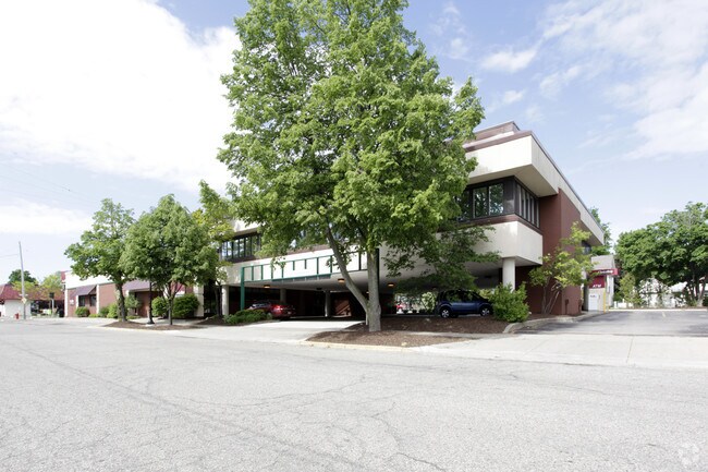
Property Detail
109 E Division St
41-05-14-351-053
LOTS 10 TO 14 INCL BLK 1 ALSO LOT 15 BLK 1 EX N 11 FT * VILLAGE OF SPARTA
Financialbuilding
Kent
VCBD
Michigan
B and X Area of moderate flood hazard, usually the area between the limits of the 100-year and 500-year floods.
10-15
2024
1.17 AC
2025
Outlying Kent County
010402
West Michigan
15,993 SF
Grand Rapids-Wyoming-Kentwood, MI
NEARBY LISTINGS FOR SALE OR LEASE
DEMOGRAPHICS near 109 E Division St
1 mile
3 mile
5 mile
2025 Total Population
4,126
9,559
18,538
2030 Population
4,191
9,735
18,954
Pop Growth 2025-2030
+ 1.58%
+ 1.84%
+ 2.24%
Average Age
39
40
40
2025 Total Households
1,677
3,679
6,878
HH Growth 2025-2030
+ 1.73%
+ 1.90%
+ 2.27%
Median Household Inc
$57,659
$78,115
$84,668
Avg Household Size
2.40
2.60
2.70
2025 Avg HH Vehicles
2.00
2.00
2.00
Median Home Value
$234,278
$275,665
$303,028
Median Year Built
1964
1977
1982
Nearby Places
Map Layers
Map Styles
 Street
 Aerial
Layers
 Traffic
 Biking
Places
Listings with unknown addresses are not visible on the map
- Restaurants
- Banks
- Shops
- Fitness
- Groceries
PUBLIC TRANSPORTATION
AIRPORT
Gerald R Ford International
Drive
Walk
Distance
Gerald R Ford International
42 min
28.2 mi
Nearby Properties
Address
Land Use
TOTAL SIZE
Lot Size
Zoning
Address
Land Use
TOTAL SIZE
Lot Size
Zoning
2,988 SF
52.77 AC
R4
Address
Land Use
TOTAL SIZE
Lot Size
Zoning
132,192 SF
7.36 AC
VR4
Address
Land Use
TOTAL SIZE
Lot Size
Zoning
96,781 SF
NONE
Address
Land Use
TOTAL SIZE
Lot Size
Zoning
131,832 SF
3.81 AC
VLI
Address
Land Use
TOTAL SIZE
Lot Size
Zoning
1,364 SF
70 AC
AG1
Address
Land Use
TOTAL SIZE
Lot Size
Zoning
13,108 SF
4.95 AC
VGC
Address
Land Use
TOTAL SIZE
Lot Size
Zoning
129,961 SF
4.67 AC
VGC
Address
Land Use
TOTAL SIZE
Lot Size
Zoning
151,576 SF
17.95 AC
VLI
Address
Land Use
TOTAL SIZE
Lot Size
Zoning
78,033 SF
6.68 AC
VLI
Address
Land Use
TOTAL SIZE
Lot Size
Zoning
3,792 SF
37.78 AC
R4
Address
Land Use
TOTAL SIZE
Lot Size
Zoning
40,025 SF
Address
Land Use
TOTAL SIZE
Lot Size
Zoning
45,981 SF
5.22 AC
VLI
Address
Land Use
TOTAL SIZE
Lot Size
Zoning
55,518 SF
5.25 AC
VGC
Address
Land Use
TOTAL SIZE
Lot Size
Zoning
84,800 SF
17.36 AC
C2
Address
Land Use
TOTAL SIZE
Lot Size
Zoning
39,482 SF
3.43 AC
VR4
Address
Land Use
TOTAL SIZE
Lot Size
Zoning
114,025 SF
11.50 AC
VLI
Address
Land Use
TOTAL SIZE
Lot Size
Zoning
39,911 SF
6.47 AC
VLI
Address
Land Use
TOTAL SIZE
Lot Size
Zoning
84,933 SF
3.11 AC
VLI
Address
Land Use
TOTAL SIZE
Lot Size
Zoning
78,145 SF
3.01 AC
VGC
Address
Land Use
TOTAL SIZE
Lot Size
Zoning
29.48 AC
R4
Address
Land Use
TOTAL SIZE
Lot Size
Zoning
Address
Land Use
TOTAL SIZE
Lot Size
Zoning
34,480 SF
3.63 AC
VR4
Address
Land Use
TOTAL SIZE
Lot Size
Zoning
12,768 SF
3.88 AC
VLI
Address
Land Use
TOTAL SIZE
Lot Size
Zoning
1,774 SF
18 AC
AG1
Address
Land Use
TOTAL SIZE
Lot Size
Zoning
Address
Land Use
TOTAL SIZE
Lot Size
Zoning
47.35 AC
AG1
Address
Land Use
TOTAL SIZE
Lot Size
Zoning
25,756 SF
2.57 AC
VGC
Address
Land Use
TOTAL SIZE
Lot Size
Zoning
43,416 SF
18.53 AC
AG1
Address
Land Use
TOTAL SIZE
Lot Size
Zoning
1,442 SF
154.37 AC
AG1
The World's #1 Commercial Real Estate Marketplace
Connect with us
© 2026 CoStar Group
The information above has been obtained from sources believed reliable. While we do not doubt its accuracy we have not verified it and make no guarantee, warranty or representation about it. It is your responsibility to independently confirm its accuracy and completeness. Any projections, opinions, assumptions, or estimates used are for example only and do not represent the current or future performance of the property. The value of this transaction to you depends on tax and other factors which should be evaluated by your tax, financial, and legal advisors. You and your advisors should conduct a careful, independent investigation of the property to determine to your satisfaction the suitability of the property for your needs.