Property Record
109 Eastern Ave, Essex, MA 01929


NEARBY LISTINGS FOR SALE OR LEASE
-
-
View all Essex listings for sale on LoopNet.com
Property Detail
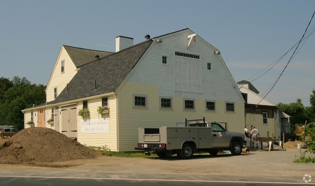
109 Eastern Ave
ESSE-000137-000000-000032
Essex
Restaurantbuilding
Massachusetts
X
32
25009C0294H
3.52 AC
2025
Essex/Gloucester
2025
Boston
222100
Boston-Cambridge-Newton, MA-NH
5,846 SF
DEMOGRAPHICS near 109 Eastern Ave
1 Mile
3 Mile
5 Mile
2024 Total Population
1,167
6,065
36,907
2029 Population
1,147
6,081
36,994
Pop Growth 2024-2029
(1.71%)
+ 0.26%
+ 0.24%
Average Age
44
44
45
2024 Total Households
479
2,461
15,127
HH Growth 2024-2029
(2.09%)
0.00%
+ 0.10%
Median Household Inc
$116,153
$110,047
$103,807
Avg Household Size
2.40
2.40
2.40
2024 Avg HH Vehicles
2.00
2.00
2.00
Median Home Value
$685,106
$682,313
$704,197
Median Year Built
1965
1969
1961
Nearby Places
Map Layers
Map Styles
 Street
 Aerial
- Restaurants
- Banks
- Shops
- Fitness
- Groceries
PUBLIC TRANSPORTATION
COMMUTER RAIL
West Gloucester (Newburyport/Rockport Line - Massachusetts Bay Transportation Authority Commuter Rail (Purple Line))
DRIVE
WALK
Distance
West Gloucester (Newburyport/Rockport Line - Massachusetts Bay Transportation Authority Commuter Rail (Purple Line))
6 min
3.5 mi
Manchester (Newburyport/Rockport Line - Massachusetts Bay Transportation Authority Commuter Rail (Purple Line))
DRIVE
WALK
Distance
Manchester (Newburyport/Rockport Line - Massachusetts Bay Transportation Authority Commuter Rail (Purple Line))
10 min
5.3 mi
AIRPORT
General Edward Lawrence Logan International
DRIVE
WALK
Distance
General Edward Lawrence Logan International
49 min
27.6 mi
Freight Ports
Port of Boston
DRIVE
WALK
Distance
Port of Boston
54 min
33.6 mi
Nearby Properties
Address
Land Use
TOTAL SIZE
Lot Size
Zoning
Address
Land Use
TOTAL SIZE
Lot Size
Zoning
67,972 SF
20.94 AC
R-20
Address
Land Use
TOTAL SIZE
Lot Size
Zoning
4.67 AC
C00
Address
Land Use
TOTAL SIZE
Lot Size
Zoning
41.14 AC
LCD
Address
Land Use
TOTAL SIZE
Lot Size
Zoning
81.17 AC
R-80
Address
Land Use
TOTAL SIZE
Lot Size
Zoning
86,343 SF
6.36 AC
LCD
Address
Land Use
TOTAL SIZE
Lot Size
Zoning
13,992 SF
16 AC
R1A
Address
Land Use
TOTAL SIZE
Lot Size
Zoning
65.50 AC
AS2
Address
Land Use
TOTAL SIZE
Lot Size
Zoning
173.75 AC
RS2
Address
Land Use
TOTAL SIZE
Lot Size
Zoning
52,259 SF
9.75 AC
Address
Land Use
TOTAL SIZE
Lot Size
Zoning
5.80 AC
IND
Address
Land Use
TOTAL SIZE
Lot Size
Zoning
12 AC
R-80
Address
Land Use
TOTAL SIZE
Lot Size
Zoning
5.86 AC
C00
Address
Land Use
TOTAL SIZE
Lot Size
Zoning
223 AC
R-40
Address
Land Use
TOTAL SIZE
Lot Size
Zoning
6.82 AC
LCD
Address
Land Use
TOTAL SIZE
Lot Size
Zoning
3.04 AC
R1B
Address
Land Use
TOTAL SIZE
Lot Size
Zoning
1.40 AC
C00
Address
Land Use
TOTAL SIZE
Lot Size
Zoning
0.87 AC
C00
Address
Land Use
TOTAL SIZE
Lot Size
Zoning
20.32 AC
R1B
Address
Land Use
TOTAL SIZE
Lot Size
Zoning
Address
Land Use
TOTAL SIZE
Lot Size
Zoning
9,910 SF
0.71 AC
C00
Address
Land Use
TOTAL SIZE
Lot Size
Zoning
25.25 AC
RS2
Address
Land Use
TOTAL SIZE
Lot Size
Zoning
5,054 SF
119.33 AC
IRA
Address
Land Use
TOTAL SIZE
Lot Size
Zoning
2,004 SF
47.80 AC
R-20
Address
Land Use
TOTAL SIZE
Lot Size
Zoning
3.08 AC
R-80
Address
Land Use
TOTAL SIZE
Lot Size
Zoning
24,000 SF
2.42 AC
LCD
Address
Land Use
TOTAL SIZE
Lot Size
Zoning
7,964 SF
LCD
Address
Land Use
TOTAL SIZE
Lot Size
Zoning
6.93 AC
RS
Address
Land Use
TOTAL SIZE
Lot Size
Zoning
0.68 AC
C00
Address
Land Use
TOTAL SIZE
Lot Size
Zoning
1.43 AC
C00
Address
Land Use
TOTAL SIZE
Lot Size
Zoning
1,536 SF
4.12 AC
EB
The World's #1 Commercial Real Estate Marketplace
Connect with us
© 2026 CoStar Group
The information above has been obtained from sources believed reliable. While we do not doubt its accuracy we have not verified it and make no guarantee, warranty or representation about it. It is your responsibility to independently confirm its accuracy and completeness. Any projections, opinions, assumptions, or estimates used are for example only and do not represent the current or future performance of the property. The value of this transaction to you depends on tax and other factors which should be evaluated by your tax, financial, and legal advisors. You and your advisors should conduct a careful, independent investigation of the property to determine to your satisfaction the suitability of the property for your needs.