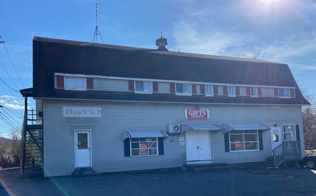
Property Record
109 Main St, Sparrow Bush, NY 12780

Current Lease Availabilities
NEARBY LISTINGS FOR SALE OR LEASE
Property Detail
109 Main St
New York-Jersey City-White Plains, NY-NJ
Orange
332800-043-000-0005-001.000-0000
New York
Townhouserowhouse
0.21 AC
X
Middletown
36071C0213E
Northern New Jersey
4,331 SF
DEMOGRAPHICS near 109 Main St
1 Mile
3 Mile
5 Mile
2024 Total Population
898
7,883
19,292
2029 Population
904
8,044
19,829
Pop Growth 2024-2029
+ 0.67%
+ 2.04%
+ 2.78%
Average Age
43
41
43
2024 Total Households
355
3,115
7,906
HH Growth 2024-2029
+ 0.56%
+ 2.05%
+ 2.97%
Median Household Inc
$68,602
$62,134
$56,522
Avg Household Size
2.50
2.50
2.40
2024 Avg HH Vehicles
2.00
2.00
2.00
Median Home Value
$208,333
$183,752
$197,350
Median Year Built
1979
1949
1964
Nearby Places
Map Layers
Map Styles
 Street
 Aerial
- Restaurants
- Banks
- Shops
- Fitness
- Groceries
PUBLIC TRANSPORTATION
COMMUTER RAIL
Port Jervis (Bergen County/Port Jervis Line - NJ Transit Commuter Rail (NJ Transit), Main/Port Jervis Line - NJ Transit Commuter Rail (NJ Transit))
DRIVE
WALK
Distance
Port Jervis (Bergen County/Port Jervis Line - NJ Transit Commuter Rail (NJ Transit), Main/Port Jervis Line - NJ Transit Commuter Rail (NJ Transit))
8 min
3.6 mi
AIRPORT
New York Stewart International
DRIVE
WALK
Distance
New York Stewart International
53 min
40.7 mi
Nearby Properties
Address
Land Use
TOTAL SIZE
Lot Size
Zoning
Address
Land Use
TOTAL SIZE
Lot Size
Zoning
1,664 SF
1.10 AC
R2
Address
Land Use
TOTAL SIZE
Lot Size
Zoning
14,077 SF
2.20 AC
MCD
Address
Land Use
TOTAL SIZE
Lot Size
Zoning
94,928 SF
77.10 AC
Address
Land Use
TOTAL SIZE
Lot Size
Zoning
97,962 SF
8.90 AC
CBD
Address
Land Use
TOTAL SIZE
Lot Size
Zoning
102,497 SF
3.90 AC
LI
Address
Land Use
TOTAL SIZE
Lot Size
Zoning
92,444 SF
12.40 AC
LI
Address
Land Use
TOTAL SIZE
Lot Size
Zoning
73,625 SF
3.60 AC
LI
Address
Land Use
TOTAL SIZE
Lot Size
Zoning
18,584 SF
1.51 AC
CBD
Address
Land Use
TOTAL SIZE
Lot Size
Zoning
62,240 SF
4.60 AC
LI
Address
Land Use
TOTAL SIZE
Lot Size
Zoning
1.82 AC
CBD
Address
Land Use
TOTAL SIZE
Lot Size
Zoning
41,300 SF
1.70 AC
LI
Address
Land Use
TOTAL SIZE
Lot Size
Zoning
39,662 SF
2.50 AC
LI
Address
Land Use
TOTAL SIZE
Lot Size
Zoning
11,320 SF
1 AC
Address
Land Use
TOTAL SIZE
Lot Size
Zoning
20,646 SF
0.36 AC
NMU
Address
Land Use
TOTAL SIZE
Lot Size
Zoning
40,500 SF
1.30 AC
LI
Address
Land Use
TOTAL SIZE
Lot Size
Zoning
19,848 SF
0.57 AC
R1
Address
Land Use
TOTAL SIZE
Lot Size
Zoning
1,200 SF
3.10 AC
MCD
Address
Land Use
TOTAL SIZE
Lot Size
Zoning
26,542 SF
2.90 AC
CBD
Address
Land Use
TOTAL SIZE
Lot Size
Zoning
0.28 AC
CBD
Address
Land Use
TOTAL SIZE
Lot Size
Zoning
6,600 SF
1.80 AC
Address
Land Use
TOTAL SIZE
Lot Size
Zoning
Address
Land Use
TOTAL SIZE
Lot Size
Zoning
7,548 SF
1.20 AC
WMU
Address
Land Use
TOTAL SIZE
Lot Size
Zoning
3,203 SF
0.59 AC
CBD
Address
Land Use
TOTAL SIZE
Lot Size
Zoning
8,490 SF
0.01 AC
NMU
Address
Land Use
TOTAL SIZE
Lot Size
Zoning
12,250 SF
0.46 AC
R1
Address
Land Use
TOTAL SIZE
Lot Size
Zoning
9,230 SF
2 AC
Address
Land Use
TOTAL SIZE
Lot Size
Zoning
15,150 SF
0.35 AC
CBD
Address
Land Use
TOTAL SIZE
Lot Size
Zoning
7.80 AC
07
Address
Land Use
TOTAL SIZE
Lot Size
Zoning
6,200 SF
80 AC
CBD
Address
Land Use
TOTAL SIZE
Lot Size
Zoning
6,196 SF
2.50 AC
The World's #1 Commercial Real Estate Marketplace
Connect with us
© 2025 CoStar Group
The information above has been obtained from sources believed reliable. While we do not doubt its accuracy we have not verified it and make no guarantee, warranty or representation about it. It is your responsibility to independently confirm its accuracy and completeness. Any projections, opinions, assumptions, or estimates used are for example only and do not represent the current or future performance of the property. The value of this transaction to you depends on tax and other factors which should be evaluated by your tax, financial, and legal advisors. You and your advisors should conduct a careful, independent investigation of the property to determine to your satisfaction the suitability of the property for your needs.