Property Record
109 N Maple St, Sycamore, IL 60178
NEARBY LISTINGS FOR SALE OR LEASE
-
-
View all Sycamore listings for sale on LoopNet.com
Property Detail
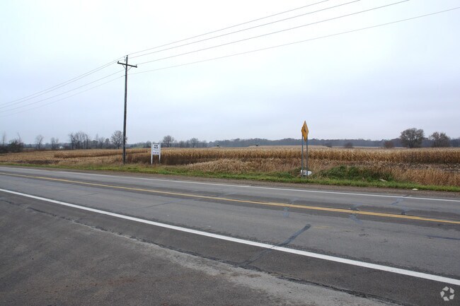
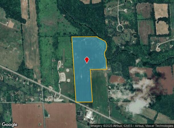
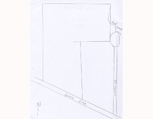
109 N Maple St
Lansing-East Lansing, MI
WMS 28-7 NE1/4 OF SW FRL1/4 SEC 28 A.K.A. GOVT LOT 4 ALSO THAT PT OF NW1/4 OF SE1/4 SEC 28 LYING W OF RED CEDAR RIVER ALSO
03-03-28-300-005
Ingham
Agriculturalland
Michigan
AE
3-4
26065C0179D
59.91 AC
2024
Williamston/Weberville
2025
West Michigan
005800
DEMOGRAPHICS near 109 N Maple St
1 Mile
3 Mile
5 Mile
2024 Total Population
220
7,859
31,077
2029 Population
214
7,727
30,617
Pop Growth 2024-2029
(2.73%)
(1.68%)
(1.48%)
Average Age
44
42
41
2024 Total Households
82
3,016
12,381
HH Growth 2024-2029
(2.44%)
(1.76%)
(1.60%)
Median Household Inc
$126,786
$116,304
$102,859
Avg Household Size
2.70
2.60
2.40
2024 Avg HH Vehicles
2.00
2.00
2.00
Median Home Value
$269,999
$288,704
$276,354
Median Year Built
1972
1981
1979
Nearby Places
Map Layers
Map Styles
 Street
 Aerial
- Restaurants
- Banks
- Shops
- Fitness
- Groceries
PUBLIC TRANSPORTATION
COMMUTER RAIL
East Lansing Amtrak Station (Blue Water - Amtrak)
DRIVE
WALK
Distance
East Lansing Amtrak Station (Blue Water - Amtrak)
19 min
9.8 mi
AIRPORT
Capital Region International
DRIVE
WALK
Distance
Capital Region International
32 min
15.4 mi
Freight Ports
Port of Toledo
DRIVE
WALK
Distance
Port of Toledo
137 min
111.5 mi
Nearby Properties
Address
Land Use
TOTAL SIZE
Lot Size
Zoning
Address
Land Use
TOTAL SIZE
Lot Size
Zoning
9,700 SF
45 AC
I-2
Address
Land Use
TOTAL SIZE
Lot Size
Zoning
63.34 AC
I-1
Address
Land Use
TOTAL SIZE
Lot Size
Zoning
48,846 SF
0.97 AC
C-1
Address
Land Use
TOTAL SIZE
Lot Size
Zoning
9,260 SF
0.58 AC
R-3
Address
Land Use
TOTAL SIZE
Lot Size
Zoning
23,184 SF
5.92 AC
B-2
Address
Land Use
TOTAL SIZE
Lot Size
Zoning
34,769 SF
2.02 AC
C-1
Address
Land Use
TOTAL SIZE
Lot Size
Zoning
13,016 SF
4.69 AC
R-3
Address
Land Use
TOTAL SIZE
Lot Size
Zoning
13,680 SF
3.83 AC
R-3
Address
Land Use
TOTAL SIZE
Lot Size
Zoning
6,054 SF
2.98 AC
RR
Address
Land Use
TOTAL SIZE
Lot Size
Zoning
2,106 SF
160 AC
AG-C
Address
Land Use
TOTAL SIZE
Lot Size
Zoning
120.08 AC
AG-SF
Address
Land Use
TOTAL SIZE
Lot Size
Zoning
5,720 SF
0.76 AC
PO-1
Address
Land Use
TOTAL SIZE
Lot Size
Zoning
7,964 SF
7.84 AC
B-2
Address
Land Use
TOTAL SIZE
Lot Size
Zoning
2,100 SF
3.01 AC
I-1
Address
Land Use
TOTAL SIZE
Lot Size
Zoning
9,260 SF
0.58 AC
Address
Land Use
TOTAL SIZE
Lot Size
Zoning
200 AC
A-2
Address
Land Use
TOTAL SIZE
Lot Size
Zoning
62.26 AC
AG-SF
Address
Land Use
TOTAL SIZE
Lot Size
Zoning
123.77 AC
RR
Address
Land Use
TOTAL SIZE
Lot Size
Zoning
10,418 SF
39.90 AC
R-1
Address
Land Use
TOTAL SIZE
Lot Size
Zoning
151.50 AC
AG-SF
Address
Land Use
TOTAL SIZE
Lot Size
Zoning
157.05 AC
AG-C
Address
Land Use
TOTAL SIZE
Lot Size
Zoning
12,409 SF
1.13 AC
B-1
Address
Land Use
TOTAL SIZE
Lot Size
Zoning
26,530 SF
9.29 AC
I-1
Address
Land Use
TOTAL SIZE
Lot Size
Zoning
1,408 SF
40 AC
RR
Address
Land Use
TOTAL SIZE
Lot Size
Zoning
5,720 SF
1.70 AC
PO-1
Address
Land Use
TOTAL SIZE
Lot Size
Zoning
14,276 SF
6.90 AC
R-1
Address
Land Use
TOTAL SIZE
Lot Size
Zoning
13,440 SF
1.48 AC
C-3
Address
Land Use
TOTAL SIZE
Lot Size
Zoning
118.35 AC
AG-SF
Address
Land Use
TOTAL SIZE
Lot Size
Zoning
8,354 SF
0.66 AC
PO-1
Address
Land Use
TOTAL SIZE
Lot Size
Zoning
22,184 SF
2.44 AC
I-2
The World's #1 Commercial Real Estate Marketplace
Connect with us
© 2025 CoStar Group
The information above has been obtained from sources believed reliable. While we do not doubt its accuracy we have not verified it and make no guarantee, warranty or representation about it. It is your responsibility to independently confirm its accuracy and completeness. Any projections, opinions, assumptions, or estimates used are for example only and do not represent the current or future performance of the property. The value of this transaction to you depends on tax and other factors which should be evaluated by your tax, financial, and legal advisors. You and your advisors should conduct a careful, independent investigation of the property to determine to your satisfaction the suitability of the property for your needs.