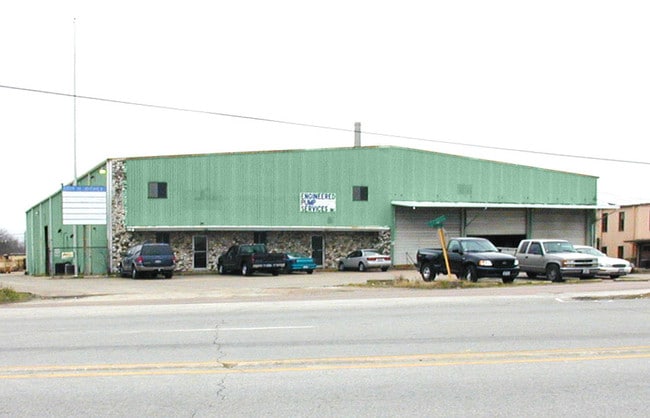
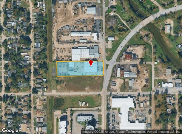
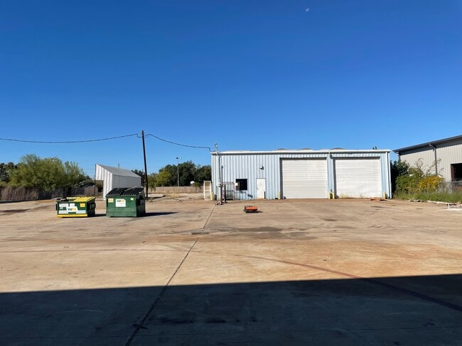
Property Record
109 N Richey St, Pasadena, TX 77506


NEARBY LISTINGS FOR SALE OR LEASE
Property Detail
109 N Richey St
Houston-The Woodlands-Sugar Land, TX
Pasadena
0281810000039
TR 17 PT LT 8 PASADENA OUTLOT 35
Warehouse
Harris
AE
Texas
48201C0905N
8
2024
2.01 AC
2025
Southeast Outer Loop
324101
Houston
20,400 SF
DEMOGRAPHICS near 109 N Richey St
1 Mile
3 Mile
5 Mile
2024 Total Population
9,239
87,471
287,387
2029 Population
9,715
89,479
294,455
Pop Growth 2024-2029
+ 5.15%
+ 2.30%
+ 2.46%
Average Age
32
35
35
2024 Total Households
2,997
26,401
92,376
HH Growth 2024-2029
+ 5.31%
+ 2.36%
+ 2.49%
Median Household Inc
$42,471
$49,476
$45,701
Avg Household Size
3.00
3.20
3.00
2024 Avg HH Vehicles
2.00
2.00
2.00
Median Home Value
$96,738
$120,309
$134,656
Median Year Built
1969
1959
1966
Nearby Places
Map Layers
Map Styles
 Street
 Aerial
- Restaurants
- Banks
- Shops
- Fitness
- Groceries
PUBLIC TRANSPORTATION
AIRPORT
William P Hobby
DRIVE
WALK
Distance
William P Hobby
20 min
8.8 mi
George Bush Intcntl/Houston
DRIVE
WALK
Distance
George Bush Intcntl/Houston
37 min
27.7 mi
Freight Ports
Port of Houston
DRIVE
WALK
Distance
Port of Houston
12 min
6.1 mi
SALE & LEASE HISTORY
LISTING DATE
SALE/LEASE

Sep 15, 2025
For Sale
Nearby Properties
Address
Land Use
TOTAL SIZE
Lot Size
Zoning
Address
Land Use
TOTAL SIZE
Lot Size
Zoning
Address
Land Use
TOTAL SIZE
Lot Size
Zoning
65.22 AC
Address
Land Use
TOTAL SIZE
Lot Size
Zoning
256.70 AC
Address
Land Use
TOTAL SIZE
Lot Size
Zoning
108.84 AC
Address
Land Use
TOTAL SIZE
Lot Size
Zoning
13,460,439 SF
191.66 AC
Address
Land Use
TOTAL SIZE
Lot Size
Zoning
873,718 SF
49.59 AC
Address
Land Use
TOTAL SIZE
Lot Size
Zoning
134.46 AC
Address
Land Use
TOTAL SIZE
Lot Size
Zoning
4,574,044 SF
102.55 AC
Address
Land Use
TOTAL SIZE
Lot Size
Zoning
1,970,716 SF
118.84 AC
Address
Land Use
TOTAL SIZE
Lot Size
Zoning
592,980 SF
20 AC
Address
Land Use
TOTAL SIZE
Lot Size
Zoning
143.17 AC
Address
Land Use
TOTAL SIZE
Lot Size
Zoning
2,019,000 SF
20 AC
Address
Land Use
TOTAL SIZE
Lot Size
Zoning
486.59 AC
Address
Land Use
TOTAL SIZE
Lot Size
Zoning
3,934,000 SF
Address
Land Use
TOTAL SIZE
Lot Size
Zoning
1,476,300 SF
39.05 AC
Address
Land Use
TOTAL SIZE
Lot Size
Zoning
4.26 AC
Address
Land Use
TOTAL SIZE
Lot Size
Zoning
165.53 AC
Address
Land Use
TOTAL SIZE
Lot Size
Zoning
2,275,058 SF
24.47 AC
Address
Land Use
TOTAL SIZE
Lot Size
Zoning
72.68 AC
Address
Land Use
TOTAL SIZE
Lot Size
Zoning
3,568,104 SF
61.61 AC
Address
Land Use
TOTAL SIZE
Lot Size
Zoning
115.83 AC
Address
Land Use
TOTAL SIZE
Lot Size
Zoning
7.19 AC
Address
Land Use
TOTAL SIZE
Lot Size
Zoning
2,918,000 SF
69.31 AC
Address
Land Use
TOTAL SIZE
Lot Size
Zoning
1,978,100 SF
50.02 AC
Address
Land Use
TOTAL SIZE
Lot Size
Zoning
4,580,000 SF
42.82 AC
Address
Land Use
TOTAL SIZE
Lot Size
Zoning
2,367,893 SF
39.85 AC
Address
Land Use
TOTAL SIZE
Lot Size
Zoning
403,776 SF
21.06 AC
Address
Land Use
TOTAL SIZE
Lot Size
Zoning
218,787 SF
10 AC
Address
Land Use
TOTAL SIZE
Lot Size
Zoning
2,778,876 SF
51.42 AC
Address
Land Use
TOTAL SIZE
Lot Size
Zoning
1,149,387 SF
36.61 AC
The World's #1 Commercial Real Estate Marketplace
Connect with us
© 2025 CoStar Group
The information above has been obtained from sources believed reliable. While we do not doubt its accuracy we have not verified it and make no guarantee, warranty or representation about it. It is your responsibility to independently confirm its accuracy and completeness. Any projections, opinions, assumptions, or estimates used are for example only and do not represent the current or future performance of the property. The value of this transaction to you depends on tax and other factors which should be evaluated by your tax, financial, and legal advisors. You and your advisors should conduct a careful, independent investigation of the property to determine to your satisfaction the suitability of the property for your needs.