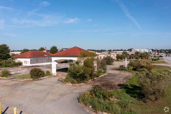
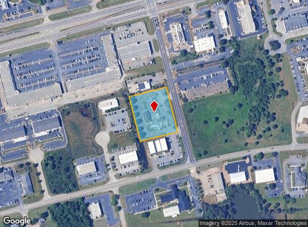
Property Record
109 Willie Lee Pkwy, Warner Robins, GA 31088
NEARBY LISTINGS FOR SALE OR LEASE
-
-
View all Warner Robins listings for sale on LoopNet.com
Property Detail
109 Willie Lee Pkwy
Warner Robins, GA
Watson 247 Conn
0W78D0232000
LOT 20B & 19 ADVANCE TECHNOLOGY PARK WEST
Hotel
Houston
X
Georgia
13225C0130C
19
2024
1.72 AC
2024
Perry/Warner Robins
021117
Other Market Areas
2,160 SF
DEMOGRAPHICS near 109 Willie Lee Pkwy
1 Mile
3 Mile
5 Mile
2024 Total Population
5,373
44,110
108,618
2029 Population
5,903
48,094
118,217
Pop Growth 2024-2029
+ 9.86%
+ 9.03%
+ 8.84%
Average Age
40
38
38
2024 Total Households
2,374
17,764
42,583
HH Growth 2024-2029
+ 9.69%
+ 8.82%
+ 8.66%
Median Household Inc
$67,011
$64,668
$66,242
Avg Household Size
2.20
2.50
2.50
2024 Avg HH Vehicles
2.00
2.00
2.00
Median Home Value
$174,856
$156,209
$157,692
Median Year Built
2000
1993
1990
Nearby Places
Map Layers
Map Styles
 Street
 Aerial
- Restaurants
- Banks
- Shops
- Fitness
- Groceries
Nearby Properties
Address
Land Use
TOTAL SIZE
Lot Size
Zoning
Address
Land Use
TOTAL SIZE
Lot Size
Zoning
27,504 SF
26.31 AC
PUD
Address
Land Use
TOTAL SIZE
Lot Size
Zoning
9,600 SF
24.25 AC
C-H
Address
Land Use
TOTAL SIZE
Lot Size
Zoning
5,400 SF
22.93 AC
R4
Address
Land Use
TOTAL SIZE
Lot Size
Zoning
5,648 SF
49.72 AC
R4
Address
Land Use
TOTAL SIZE
Lot Size
Zoning
14,754 SF
24 AC
C2
Address
Land Use
TOTAL SIZE
Lot Size
Zoning
15,006 SF
28 AC
PDE
Address
Land Use
TOTAL SIZE
Lot Size
Zoning
26,271 SF
17.43 AC
C2
Address
Land Use
TOTAL SIZE
Lot Size
Zoning
7,172 SF
24.73 AC
R4
Address
Land Use
TOTAL SIZE
Lot Size
Zoning
226,032 SF
49.90 AC
C2
Address
Land Use
TOTAL SIZE
Lot Size
Zoning
11,056 SF
17.41 AC
R4
Address
Land Use
TOTAL SIZE
Lot Size
Zoning
301,206 SF
19.79 AC
C2
Address
Land Use
TOTAL SIZE
Lot Size
Zoning
338,708 SF
28.28 AC
M-2
Address
Land Use
TOTAL SIZE
Lot Size
Zoning
18,954 SF
20 AC
C2
Address
Land Use
TOTAL SIZE
Lot Size
Zoning
28,668 SF
17.38 AC
R4 C2
Address
Land Use
TOTAL SIZE
Lot Size
Zoning
92,930 SF
18.66 AC
C2
Address
Land Use
TOTAL SIZE
Lot Size
Zoning
158,300 SF
29.99 AC
R1
Address
Land Use
TOTAL SIZE
Lot Size
Zoning
21,750 SF
11.48 AC
C2
Address
Land Use
TOTAL SIZE
Lot Size
Zoning
16,570 SF
15.62 AC
R4
Address
Land Use
TOTAL SIZE
Lot Size
Zoning
63,274 SF
40.80 AC
C-2, WR
Address
Land Use
TOTAL SIZE
Lot Size
Zoning
223,608 SF
22.40 AC
C2
Address
Land Use
TOTAL SIZE
Lot Size
Zoning
76,751 SF
26.32 AC
R1
Address
Land Use
TOTAL SIZE
Lot Size
Zoning
56,260 SF
17.70 AC
C2
Address
Land Use
TOTAL SIZE
Lot Size
Zoning
5,320 SF
15.47 AC
R-4
Address
Land Use
TOTAL SIZE
Lot Size
Zoning
15,184 SF
14.03 AC
R4
Address
Land Use
TOTAL SIZE
Lot Size
Zoning
156,000 SF
19.25 AC
R2
Address
Land Use
TOTAL SIZE
Lot Size
Zoning
139,016 SF
24.71 AC
C2
Address
Land Use
TOTAL SIZE
Lot Size
Zoning
100,500 SF
19.64 AC
R2
Address
Land Use
TOTAL SIZE
Lot Size
Zoning
60,300 SF
6.99 AC
M-2, WR
Address
Land Use
TOTAL SIZE
Lot Size
Zoning
100,500 SF
19.74 AC
R2
Address
Land Use
TOTAL SIZE
Lot Size
Zoning
39,810 SF
26.92 AC
C1
The World's #1 Commercial Real Estate Marketplace
Connect with us
© 2025 CoStar Group
The information above has been obtained from sources believed reliable. While we do not doubt its accuracy we have not verified it and make no guarantee, warranty or representation about it. It is your responsibility to independently confirm its accuracy and completeness. Any projections, opinions, assumptions, or estimates used are for example only and do not represent the current or future performance of the property. The value of this transaction to you depends on tax and other factors which should be evaluated by your tax, financial, and legal advisors. You and your advisors should conduct a careful, independent investigation of the property to determine to your satisfaction the suitability of the property for your needs.