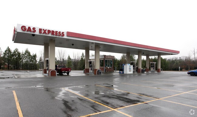
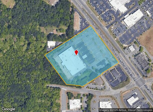
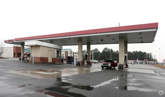
Property Record
1090 Buford Rd, Cumming, GA 30041
NEARBY LISTINGS FOR SALE OR LEASE
Property Detail
1090 Buford Rd
Atlanta-Sandy Springs-Roswell, GA
Market Place Dis
173-304
2-1 282-295-296
Regionalshoppingcenterormallwithanchorstore
Forsyth
X
Georgia
13117C0142F
282,295
2024
9.75 AC
2025
Cumming/Forsyth Cnty
130512
Atlanta
192 SF
DEMOGRAPHICS near 1090 Buford Rd
1 Mile
3 Mile
5 Mile
2024 Total Population
4,573
46,590
119,973
2029 Population
5,345
54,209
138,287
Pop Growth 2024-2029
+ 16.88%
+ 16.35%
+ 15.27%
Average Age
40
39
39
2024 Total Households
1,531
16,079
40,112
HH Growth 2024-2029
+ 16.79%
+ 16.47%
+ 15.46%
Median Household Inc
$137,185
$111,976
$120,577
Avg Household Size
3.00
2.80
2.90
2024 Avg HH Vehicles
2.00
2.00
2.00
Median Home Value
$424,230
$429,217
$446,933
Median Year Built
2003
2003
2003
Nearby Places
- Restaurants
- Banks
- Shops
- Fitness
- Groceries
Nearby Properties
Address
Land Use
TOTAL SIZE
Lot Size
Zoning
Address
Land Use
TOTAL SIZE
Lot Size
Zoning
581,433 SF
31.45 AC
INST
Address
Land Use
TOTAL SIZE
Lot Size
Zoning
8,848 SF
15.75 AC
PUD
Address
Land Use
TOTAL SIZE
Lot Size
Zoning
10.82 AC
PUD
Address
Land Use
TOTAL SIZE
Lot Size
Zoning
10.57 AC
PUD
Address
Land Use
TOTAL SIZE
Lot Size
Zoning
15,081 SF
27.53 AC
R3
Address
Land Use
TOTAL SIZE
Lot Size
Zoning
208,496 SF
23.61 AC
R3
Address
Land Use
TOTAL SIZE
Lot Size
Zoning
312,095 SF
28.86 AC
PSC
Address
Land Use
TOTAL SIZE
Lot Size
Zoning
29,763 SF
20.36 AC
MP
Address
Land Use
TOTAL SIZE
Lot Size
Zoning
302,599 SF
35.89 AC
R3
Address
Land Use
TOTAL SIZE
Lot Size
Zoning
15,600 SF
21.98 AC
R3
Address
Land Use
TOTAL SIZE
Lot Size
Zoning
173,374 SF
32.90 AC
CBD
Address
Land Use
TOTAL SIZE
Lot Size
Zoning
141,650 SF
21.58 AC
M1
Address
Land Use
TOTAL SIZE
Lot Size
Zoning
6.49 AC
PUD
Address
Land Use
TOTAL SIZE
Lot Size
Zoning
171,065 SF
16.22 AC
CBD
Address
Land Use
TOTAL SIZE
Lot Size
Zoning
149,540 SF
43.76 AC
INST
Address
Land Use
TOTAL SIZE
Lot Size
Zoning
60,235 SF
11.94 AC
CBD
Address
Land Use
TOTAL SIZE
Lot Size
Zoning
120,750 SF
9.37 AC
INST
Address
Land Use
TOTAL SIZE
Lot Size
Zoning
65,364 SF
15.29 AC
PSC
Address
Land Use
TOTAL SIZE
Lot Size
Zoning
152,562 SF
12.80 AC
R3
Address
Land Use
TOTAL SIZE
Lot Size
Zoning
290,701 SF
70.48 AC
A1
Address
Land Use
TOTAL SIZE
Lot Size
Zoning
1,600 SF
85.02 AC
RES3
Address
Land Use
TOTAL SIZE
Lot Size
Zoning
2,376 SF
68.90 AC
A1
Address
Land Use
TOTAL SIZE
Lot Size
Zoning
127,940 SF
14.30 AC
HB
Address
Land Use
TOTAL SIZE
Lot Size
Zoning
99,232 SF
Address
Land Use
TOTAL SIZE
Lot Size
Zoning
15,920 SF
9.49 AC
CBD
Address
Land Use
TOTAL SIZE
Lot Size
Zoning
24,396 SF
72.23 AC
A1
Address
Land Use
TOTAL SIZE
Lot Size
Zoning
109,856 SF
12.94 AC
CBD
Address
Land Use
TOTAL SIZE
Lot Size
Zoning
267,180 SF
31.01 AC
INST
Address
Land Use
TOTAL SIZE
Lot Size
Zoning
98,593 SF
34.52 AC
R2R
Address
Land Use
TOTAL SIZE
Lot Size
Zoning
111,194 SF
13.53 AC
NS
The World's #1 Commercial Real Estate Marketplace
Connect with us
© 2025 CoStar Group
The information above has been obtained from sources believed reliable. While we do not doubt its accuracy we have not verified it and make no guarantee, warranty or representation about it. It is your responsibility to independently confirm its accuracy and completeness. Any projections, opinions, assumptions, or estimates used are for example only and do not represent the current or future performance of the property. The value of this transaction to you depends on tax and other factors which should be evaluated by your tax, financial, and legal advisors. You and your advisors should conduct a careful, independent investigation of the property to determine to your satisfaction the suitability of the property for your needs.