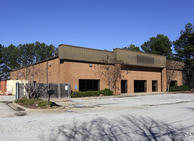
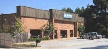
Property Record
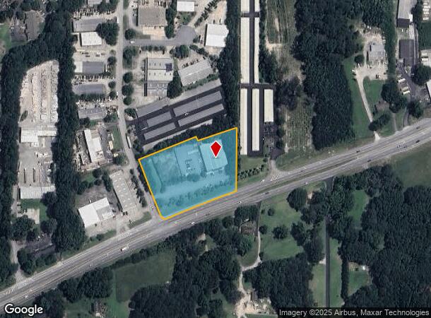
1090 Highway 54 E, Fayetteville, GA 30214

NEARBY LISTINGS FOR SALE OR LEASE
Property Detail
1090 Highway 54 E
Atlanta-Sandy Springs-Roswell, GA
Fayette Industrial Park
05-32-06-001
LOT 1 EAST FAYETTE IND PARK
Animalhospitalvet
Fayette
X
Georgia
13113C0108E
1
2024
3.03 AC
2024
Fayette/Peachtree
140406
Atlanta
12,000 SF
DEMOGRAPHICS near 1090 Highway 54 E
1 Mile
3 Mile
5 Mile
2024 Total Population
4,698
28,055
88,885
2029 Population
4,967
29,521
91,594
Pop Growth 2024-2029
+ 5.73%
+ 5.23%
+ 3.05%
Average Age
41
42
40
2024 Total Households
1,879
10,566
31,067
HH Growth 2024-2029
+ 5.69%
+ 5.27%
+ 3.18%
Median Household Inc
$57,036
$72,149
$74,341
Avg Household Size
2.50
2.60
2.80
2024 Avg HH Vehicles
2.00
2.00
2.00
Median Home Value
$245,738
$265,856
$247,752
Median Year Built
1995
1992
1992
Nearby Places
Map Layers
Map Styles
 Street
 Aerial
- Restaurants
- Banks
- Shops
- Fitness
- Groceries
PUBLIC TRANSPORTATION
AIRPORT
Hartsfield - Jackson Atlanta International
DRIVE
WALK
Distance
Hartsfield - Jackson Atlanta International
30 min
16.2 mi
Freight Ports
Georgia Ports - Savannah
DRIVE
WALK
Distance
Georgia Ports - Savannah
269 min
235.7 mi
Nearby Properties
Address
Land Use
TOTAL SIZE
Lot Size
Zoning
Address
Land Use
TOTAL SIZE
Lot Size
Zoning
224,116 SF
41.20 AC
MUC
Address
Land Use
TOTAL SIZE
Lot Size
Zoning
197,026 SF
28 AC
Address
Land Use
TOTAL SIZE
Lot Size
Zoning
88,509 SF
31.54 AC
C C3
Address
Land Use
TOTAL SIZE
Lot Size
Zoning
151,194 SF
11.59 AC
C PUD
Address
Land Use
TOTAL SIZE
Lot Size
Zoning
80,942 SF
44.16 AC
C CH
Address
Land Use
TOTAL SIZE
Lot Size
Zoning
232,852 SF
35.39 AC
C C3
Address
Land Use
TOTAL SIZE
Lot Size
Zoning
158,310 SF
4.76 AC
C C1
Address
Land Use
TOTAL SIZE
Lot Size
Zoning
260,883 SF
21.30 AC
C C3
Address
Land Use
TOTAL SIZE
Lot Size
Zoning
111,198 SF
8.94 AC
C C1
Address
Land Use
TOTAL SIZE
Lot Size
Zoning
92,550 SF
10.70 AC
C C1
Address
Land Use
TOTAL SIZE
Lot Size
Zoning
120,793 SF
5.60 AC
C PUD
Address
Land Use
TOTAL SIZE
Lot Size
Zoning
112,650 SF
22.78 AC
C RMF15
Address
Land Use
TOTAL SIZE
Lot Size
Zoning
132,197 SF
18 AC
C RMF15
Address
Land Use
TOTAL SIZE
Lot Size
Zoning
220,887 SF
24.70 AC
Address
Land Use
TOTAL SIZE
Lot Size
Zoning
103,641 SF
17.60 AC
C C3
Address
Land Use
TOTAL SIZE
Lot Size
Zoning
239,954 SF
77.70 AC
Address
Land Use
TOTAL SIZE
Lot Size
Zoning
35,356 SF
2.01 AC
C C1
Address
Land Use
TOTAL SIZE
Lot Size
Zoning
210,122 SF
16.77 AC
C C3
Address
Land Use
TOTAL SIZE
Lot Size
Zoning
184,862 SF
21.90 AC
C C3
Address
Land Use
TOTAL SIZE
Lot Size
Zoning
107,232 SF
13.82 AC
C C3
Address
Land Use
TOTAL SIZE
Lot Size
Zoning
102,460 SF
10 AC
C CH
Address
Land Use
TOTAL SIZE
Lot Size
Zoning
127,836 SF
14.33 AC
C CH
Address
Land Use
TOTAL SIZE
Lot Size
Zoning
135,115 SF
32.15 AC
Address
Land Use
TOTAL SIZE
Lot Size
Zoning
199,132 SF
19.59 AC
C PUD
Address
Land Use
TOTAL SIZE
Lot Size
Zoning
136,320 SF
19.51 AC
C C3
Address
Land Use
TOTAL SIZE
Lot Size
Zoning
56,192 SF
9.40 AC
C RMF15
Address
Land Use
TOTAL SIZE
Lot Size
Zoning
75,043 SF
3.20 AC
HC
Address
Land Use
TOTAL SIZE
Lot Size
Zoning
49,261 SF
4.33 AC
C C3
Address
Land Use
TOTAL SIZE
Lot Size
Zoning
41,450 SF
3.87 AC
C OI
Address
Land Use
TOTAL SIZE
Lot Size
Zoning
65,951 SF
6.70 AC
C C3
The World's #1 Commercial Real Estate Marketplace
Connect with us
© 2025 CoStar Group
The information above has been obtained from sources believed reliable. While we do not doubt its accuracy we have not verified it and make no guarantee, warranty or representation about it. It is your responsibility to independently confirm its accuracy and completeness. Any projections, opinions, assumptions, or estimates used are for example only and do not represent the current or future performance of the property. The value of this transaction to you depends on tax and other factors which should be evaluated by your tax, financial, and legal advisors. You and your advisors should conduct a careful, independent investigation of the property to determine to your satisfaction the suitability of the property for your needs.