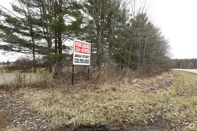
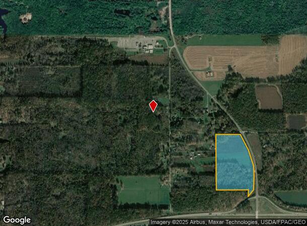
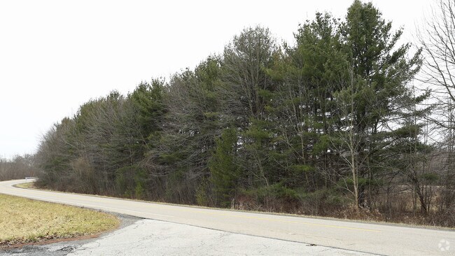
Property Record
1090 N Pricetown Rd, Diamond, OH 44412

NEARBY LISTINGS FOR SALE OR LEASE
Property Detail
1090 N Pricetown Rd
Youngstown/Warren/Boardman
Milton Township
Youngstown-Warren-Boardman, OH-PA
GL 18
51-108-0-001.02-0
Mahoning
Agriculturalland
Ohio
2024
25.57 AC
2024
Mahoning County
812800
DEMOGRAPHICS near 1090 N Pricetown Rd
1 Mile
3 Mile
5 Mile
2024 Total Population
156
4,200
10,784
2029 Population
148
4,194
10,609
Pop Growth 2024-2029
(5.13%)
(0.14%)
(1.62%)
Average Age
45
46
45
2024 Total Households
63
1,792
4,515
HH Growth 2024-2029
(6.35%)
0.00%
(1.57%)
Median Household Inc
$72,187
$67,088
$66,809
Avg Household Size
2.50
2.30
2.30
2024 Avg HH Vehicles
3.00
2.00
2.00
Median Home Value
$253,571
$232,812
$199,594
Median Year Built
1976
1973
1973
Nearby Places
Map Layers
Map Styles
 Street
 Aerial
- Restaurants
- Banks
- Shops
- Fitness
- Groceries
PUBLIC TRANSPORTATION
AIRPORT
Akron-Canton Regional
DRIVE
WALK
Distance
Akron-Canton Regional
51 min
43.2 mi
Freight Ports
Port of Toledo
DRIVE
WALK
Distance
Port of Toledo
186 min
156.8 mi
SALE & LEASE HISTORY
LISTING DATE
SALE/LEASE

Feb 16, 2017
For Sale
Feb 09, 2018
For Lease
Nearby Properties
Address
Land Use
TOTAL SIZE
Lot Size
Zoning
Address
Land Use
TOTAL SIZE
Lot Size
Zoning
90,602 SF
100.46 AC
AG
Address
Land Use
TOTAL SIZE
Lot Size
Zoning
5,436 SF
2,373.66 AC
AG
Address
Land Use
TOTAL SIZE
Lot Size
Zoning
65,256 SF
20 AC
AG
Address
Land Use
TOTAL SIZE
Lot Size
Zoning
27,205 SF
2.35 AC
AG
Address
Land Use
TOTAL SIZE
Lot Size
Zoning
5,700 SF
7.09 AC
C2
Address
Land Use
TOTAL SIZE
Lot Size
Zoning
2,908 SF
42.18 AC
AG
Address
Land Use
TOTAL SIZE
Lot Size
Zoning
24,724 SF
2.36 AC
C2
Address
Land Use
TOTAL SIZE
Lot Size
Zoning
12,040 SF
2.31 AC
C2
Address
Land Use
TOTAL SIZE
Lot Size
Zoning
6,733 SF
2.62 AC
Address
Land Use
TOTAL SIZE
Lot Size
Zoning
3,662 SF
55.53 AC
AG
Address
Land Use
TOTAL SIZE
Lot Size
Zoning
5,016 SF
7.94 AC
R1
Address
Land Use
TOTAL SIZE
Lot Size
Zoning
11,089 SF
5.03 AC
R3
Address
Land Use
TOTAL SIZE
Lot Size
Zoning
4,196 SF
163.11 AC
AG
Address
Land Use
TOTAL SIZE
Lot Size
Zoning
8,352 SF
92.03 AC
AG
Address
Land Use
TOTAL SIZE
Lot Size
Zoning
60.65 AC
AG
Address
Land Use
TOTAL SIZE
Lot Size
Zoning
3,652 SF
96.21 AC
AG
Address
Land Use
TOTAL SIZE
Lot Size
Zoning
7,500 SF
5.68 AC
C2
Address
Land Use
TOTAL SIZE
Lot Size
Zoning
Address
Land Use
TOTAL SIZE
Lot Size
Zoning
6,704 SF
101.81 AC
AG
Address
Land Use
TOTAL SIZE
Lot Size
Zoning
4,484 SF
109.10 AC
AG
Address
Land Use
TOTAL SIZE
Lot Size
Zoning
9,283 SF
0.93 AC
Address
Land Use
TOTAL SIZE
Lot Size
Zoning
9,170 SF
7.75 AC
C2
Address
Land Use
TOTAL SIZE
Lot Size
Zoning
7,260 SF
69.53 AC
ASER
Address
Land Use
TOTAL SIZE
Lot Size
Zoning
1,885 SF
6.63 AC
Address
Land Use
TOTAL SIZE
Lot Size
Zoning
4,447 SF
40.24 AC
Address
Land Use
TOTAL SIZE
Lot Size
Zoning
12,664 SF
38 AC
AG
Address
Land Use
TOTAL SIZE
Lot Size
Zoning
6.56 AC
Address
Land Use
TOTAL SIZE
Lot Size
Zoning
Address
Land Use
TOTAL SIZE
Lot Size
Zoning
4,335 SF
100.25 AC
AG
Address
Land Use
TOTAL SIZE
Lot Size
Zoning
8,320 SF
1.09 AC
C2
The World's #1 Commercial Real Estate Marketplace
Connect with us
© 2025 CoStar Group
The information above has been obtained from sources believed reliable. While we do not doubt its accuracy we have not verified it and make no guarantee, warranty or representation about it. It is your responsibility to independently confirm its accuracy and completeness. Any projections, opinions, assumptions, or estimates used are for example only and do not represent the current or future performance of the property. The value of this transaction to you depends on tax and other factors which should be evaluated by your tax, financial, and legal advisors. You and your advisors should conduct a careful, independent investigation of the property to determine to your satisfaction the suitability of the property for your needs.