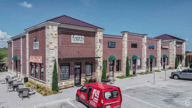
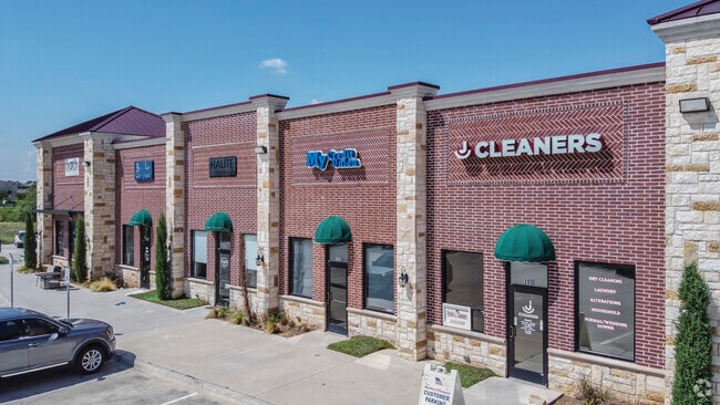
Property Record
1090 Schoolhouse Rd, Haslet, TX 76052


Current Lease Availabilities
Property Detail
1090 Schoolhouse Rd
Dallas-Fort Worth-Arlington, TX
SCHOOL HOUSE 156 CORNER BLOCK 1 LOT 2R
42777524
TARRANT
Commercialnec
Texas
AE The base floodplain where base flood elevations are provided. AE Zones are now used on new format FIRMs instead of A1-A30 Zones.
2r
2025
0.90 AC
2025
Northwest Fort Worth
113932
Dallas/Ft Worth
8,190 SF
NEARBY LISTINGS FOR SALE OR LEASE
-
-
-
-
-
-
The Shops at Sendera Ranch 13951 Sendera Ranch Blvd
Haslet, TX 76052
Negotiable
1,200 - 7,302 SF
Retail
-
-
View all Haslet listings for lease on LoopNet.com
DEMOGRAPHICS near 1090 Schoolhouse Rd
1 mile
3 mile
5 mile
2025 Total Population
1,873
33,136
133,986
2030 Population
2,088
36,445
144,917
Pop Growth 2025-2030
+ 11.48%
+ 9.99%
+ 8.16%
Average Age
40
35
35
2025 Total Households
670
10,668
43,240
HH Growth 2025-2030
+ 11.64%
+ 10.04%
+ 8.39%
Median Household Inc
$146,265
$138,400
$121,908
Avg Household Size
2.80
3.10
3.10
2025 Avg HH Vehicles
2.00
2.00
2.00
Median Home Value
$685,840
$439,316
$392,746
Median Year Built
2010
2010
2010
Nearby Places
Map Layers
Map Styles
 Street
 Aerial
Transit
 Traffic
 Biking
Places
Listings with unknown addresses are not visible on the map
- Restaurants
- Banks
- Shops
- Fitness
- Groceries
PUBLIC TRANSPORTATION
AIRPORT
Dallas-Fort Worth International
Drive
Walk
Distance
Dallas-Fort Worth International
34 min
24.5 mi
Dallas Love Field
Drive
Walk
Distance
Dallas Love Field
51 min
39.0 mi
Nearby Properties
Address
Land Use
TOTAL SIZE
Lot Size
Zoning
Address
Land Use
TOTAL SIZE
Lot Size
Zoning
348,270 SF
39.34 AC
Address
Land Use
TOTAL SIZE
Lot Size
Zoning
830,399 SF
11.02 AC
Address
Land Use
TOTAL SIZE
Lot Size
Zoning
553,605 SF
81.10 AC
Address
Land Use
TOTAL SIZE
Lot Size
Zoning
681,942 SF
29.37 AC
Address
Land Use
TOTAL SIZE
Lot Size
Zoning
471,000 SF
18.34 AC
Address
Land Use
TOTAL SIZE
Lot Size
Zoning
1,150,000 SF
117.10 AC
Address
Land Use
TOTAL SIZE
Lot Size
Zoning
1,141,133 SF
67.79 AC
Address
Land Use
TOTAL SIZE
Lot Size
Zoning
1,179,900 SF
73.58 AC
Address
Land Use
TOTAL SIZE
Lot Size
Zoning
422,682 SF
22.66 AC
Address
Land Use
TOTAL SIZE
Lot Size
Zoning
504,000 SF
26.39 AC
Address
Land Use
TOTAL SIZE
Lot Size
Zoning
882,565 SF
56.65 AC
Address
Land Use
TOTAL SIZE
Lot Size
Zoning
1,001,600 SF
58.47 AC
Address
Land Use
TOTAL SIZE
Lot Size
Zoning
1,140,525 SF
45.79 AC
Address
Land Use
TOTAL SIZE
Lot Size
Zoning
175,000 SF
14.48 AC
Address
Land Use
TOTAL SIZE
Lot Size
Zoning
807,229 SF
46.10 AC
Address
Land Use
TOTAL SIZE
Lot Size
Zoning
295,161 SF
257.32 AC
Address
Land Use
TOTAL SIZE
Lot Size
Zoning
727,900 SF
40.15 AC
Address
Land Use
TOTAL SIZE
Lot Size
Zoning
707,940 SF
35.33 AC
Address
Land Use
TOTAL SIZE
Lot Size
Zoning
677,700 SF
42.17 AC
Address
Land Use
TOTAL SIZE
Lot Size
Zoning
267,831 SF
17.40 AC
Address
Land Use
TOTAL SIZE
Lot Size
Zoning
634,042 SF
35.88 AC
Address
Land Use
TOTAL SIZE
Lot Size
Zoning
562,500 SF
29.64 AC
Address
Land Use
TOTAL SIZE
Lot Size
Zoning
731,548 SF
56.18 AC
Address
Land Use
TOTAL SIZE
Lot Size
Zoning
487,350 SF
26.34 AC
Address
Land Use
TOTAL SIZE
Lot Size
Zoning
436,589 SF
32.43 AC
Address
Land Use
TOTAL SIZE
Lot Size
Zoning
433,500 SF
27.58 AC
Address
Land Use
TOTAL SIZE
Lot Size
Zoning
360,000 SF
28.63 AC
Address
Land Use
TOTAL SIZE
Lot Size
Zoning
382,065 SF
22.24 AC
Address
Land Use
TOTAL SIZE
Lot Size
Zoning
422,373 SF
25.13 AC
Address
Land Use
TOTAL SIZE
Lot Size
Zoning
161,042 SF
5.72 AC
The World's #1 Commercial Real Estate Marketplace
Connect with us
© 2026 CoStar Group
The information above has been obtained from sources believed reliable. While we do not doubt its accuracy we have not verified it and make no guarantee, warranty or representation about it. It is your responsibility to independently confirm its accuracy and completeness. Any projections, opinions, assumptions, or estimates used are for example only and do not represent the current or future performance of the property. The value of this transaction to you depends on tax and other factors which should be evaluated by your tax, financial, and legal advisors. You and your advisors should conduct a careful, independent investigation of the property to determine to your satisfaction the suitability of the property for your needs.