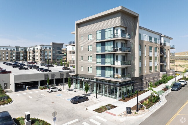
Property Record
10930 High Note Ave, Parker, CO 80134
Current Lease Availabilities
Property Detail
10930 High Note Ave
Denver-Aurora-Centennial, CO
LOT 2-A-2 RIDGEGATE EAST 1 2ND AMD 4.555 AM/L
2231-232-01-007
DOUGLAS
Apartment
Colorado
B and X Area of moderate flood hazard, usually the area between the limits of the 100-year and 500-year floods.
2-a-2
2024
4.56 AC
2025
South Douglas County
014011
Denver
297,111 SF
NEARBY LISTINGS FOR SALE OR LEASE
-
-
View all Parker listings for lease on LoopNet.com
DEMOGRAPHICS near 10930 High Note Ave
1 mile
3 mile
5 mile
2025 Total Population
4,615
49,744
172,382
2030 Population
5,073
53,775
183,792
Pop Growth 2025-2030
+ 9.92%
+ 8.10%
+ 6.62%
Average Age
38
38
39
2025 Total Households
2,055
19,845
65,204
HH Growth 2025-2030
+ 10.02%
+ 8.51%
+ 6.85%
Median Household Inc
$123,203
$131,928
$137,222
Avg Household Size
2.20
2.50
2.60
2025 Avg HH Vehicles
2.00
2.00
2.00
Median Home Value
$791,918
$790,782
$741,314
Median Year Built
2011
2009
2002
Nearby Places
Map Layers
Map Styles
 Street
 Aerial
Transit
 Traffic
 Biking
Places
Listings with unknown addresses are not visible on the map
- Restaurants
- Banks
- Shops
- Fitness
- Groceries
PUBLIC TRANSPORTATION
AIRPORT
Denver International
Drive
Walk
Distance
Denver International
39 min
34.2 mi
Nearby Properties
Address
Land Use
TOTAL SIZE
Lot Size
Zoning
Address
Land Use
TOTAL SIZE
Lot Size
Zoning
709,725 SF
15.21 AC
Address
Land Use
TOTAL SIZE
Lot Size
Zoning
709,725 SF
29.14 AC
Address
Land Use
TOTAL SIZE
Lot Size
Zoning
805,440 SF
28.65 AC
Address
Land Use
TOTAL SIZE
Lot Size
Zoning
260,667 SF
19.72 AC
Address
Land Use
TOTAL SIZE
Lot Size
Zoning
1,630,979 SF
32.01 AC
Address
Land Use
TOTAL SIZE
Lot Size
Zoning
162,758 SF
11.21 AC
Address
Land Use
TOTAL SIZE
Lot Size
Zoning
621,565 SF
32.64 AC
PDU
Address
Land Use
TOTAL SIZE
Lot Size
Zoning
163,443 SF
14.39 AC
Address
Land Use
TOTAL SIZE
Lot Size
Zoning
650,416 SF
33.37 AC
LI
Address
Land Use
TOTAL SIZE
Lot Size
Zoning
661,139 SF
Address
Land Use
TOTAL SIZE
Lot Size
Zoning
128,812 SF
2.55 AC
Address
Land Use
TOTAL SIZE
Lot Size
Zoning
418,258 SF
14.46 AC
PDU
Address
Land Use
TOTAL SIZE
Lot Size
Zoning
126,202 SF
2.27 AC
Address
Land Use
TOTAL SIZE
Lot Size
Zoning
112,021 SF
3.17 AC
Address
Land Use
TOTAL SIZE
Lot Size
Zoning
494,862 SF
30.59 AC
PDU
Address
Land Use
TOTAL SIZE
Lot Size
Zoning
632,485 SF
38.43 AC
PDU
Address
Land Use
TOTAL SIZE
Lot Size
Zoning
181,361 SF
549.62 AC
Address
Land Use
TOTAL SIZE
Lot Size
Zoning
651,701 SF
10.77 AC
PDU
Address
Land Use
TOTAL SIZE
Lot Size
Zoning
187,757 SF
7.47 AC
Address
Land Use
TOTAL SIZE
Lot Size
Zoning
122,017 SF
11.39 AC
PDU
Address
Land Use
TOTAL SIZE
Lot Size
Zoning
99,678 SF
10.25 AC
Address
Land Use
TOTAL SIZE
Lot Size
Zoning
324,829 SF
20.45 AC
SR
Address
Land Use
TOTAL SIZE
Lot Size
Zoning
190,344 SF
10.77 AC
PDU
Address
Land Use
TOTAL SIZE
Lot Size
Zoning
80,178 SF
4.85 AC
Address
Land Use
TOTAL SIZE
Lot Size
Zoning
277,142 SF
17.74 AC
PDU
Address
Land Use
TOTAL SIZE
Lot Size
Zoning
196,390 SF
13.10 AC
Address
Land Use
TOTAL SIZE
Lot Size
Zoning
172,792 SF
16.48 AC
LI
Address
Land Use
TOTAL SIZE
Lot Size
Zoning
87,947 SF
5.42 AC
Address
Land Use
TOTAL SIZE
Lot Size
Zoning
146,965 SF
30.93 AC
Address
Land Use
TOTAL SIZE
Lot Size
Zoning
73,149 SF
14.10 AC
PDU
The World's #1 Commercial Real Estate Marketplace
Connect with us
© 2026 CoStar Group
The information above has been obtained from sources believed reliable. While we do not doubt its accuracy we have not verified it and make no guarantee, warranty or representation about it. It is your responsibility to independently confirm its accuracy and completeness. Any projections, opinions, assumptions, or estimates used are for example only and do not represent the current or future performance of the property. The value of this transaction to you depends on tax and other factors which should be evaluated by your tax, financial, and legal advisors. You and your advisors should conduct a careful, independent investigation of the property to determine to your satisfaction the suitability of the property for your needs.