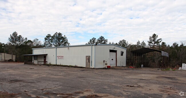
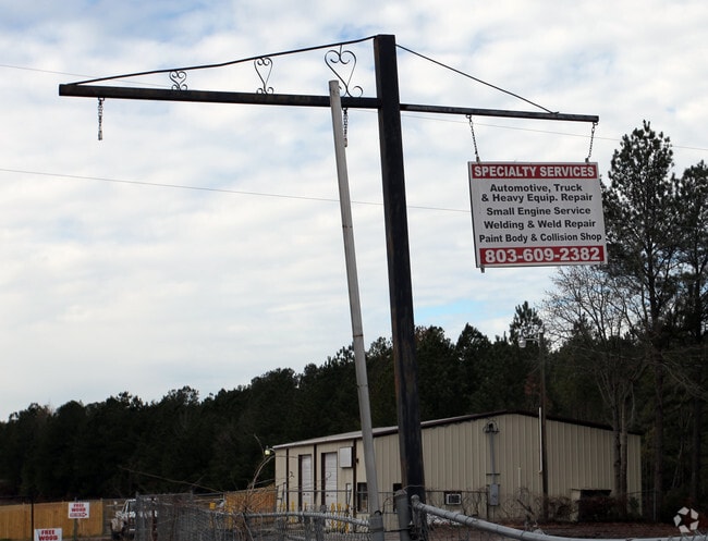
Property Record
10901 Two Notch Rd, Elgin, SC 29045

Property Detail
10901 Two Notch Rd
29000-01-05
182.2X198.9X214.2X257.6 #SU #PR Z-1257
Commercialnec
Richland
GC
South Carolina
B and X Area of moderate flood hazard, usually the area between the limits of the 100-year and 500-year floods.
1.01 AC
2025
Northeast Columbia
2024
Columbia
011425
Columbia, SC
3,000 SF
NEARBY LISTINGS FOR SALE OR LEASE
-
-
View all Elgin listings for sale on LoopNet.com
DEMOGRAPHICS near 10901 Two Notch Rd
1 mile
3 mile
5 mile
2025 Total Population
2,286
29,639
81,092
2030 Population
2,373
31,064
84,591
Pop Growth 2025-2030
+ 3.81%
+ 4.81%
+ 4.31%
Average Age
36
38
39
2025 Total Households
798
11,171
30,957
HH Growth 2025-2030
+ 4.26%
+ 5.00%
+ 4.38%
Median Household Inc
$83,928
$84,496
$81,984
Avg Household Size
2.90
2.60
2.60
2025 Avg HH Vehicles
2.00
2.00
2.00
Median Home Value
$295,174
$263,234
$261,901
Median Year Built
2010
2004
2002
Nearby Places
Map Layers
Map Styles
 Street
 Aerial
Transit
 Traffic
 Biking
Places
Listings with unknown addresses are not visible on the map
- Restaurants
- Banks
- Shops
- Fitness
- Groceries
PUBLIC TRANSPORTATION
AIRPORT
Columbia Metro
Drive
Walk
Distance
Columbia Metro
48 min
27.8 mi
Freight Ports
North Charleston Terminal
Drive
Walk
Distance
North Charleston Terminal
143 min
123.5 mi
Nearby Properties
Address
Land Use
TOTAL SIZE
Lot Size
Zoning
Address
Land Use
TOTAL SIZE
Lot Size
Zoning
333,002 SF
8.39 AC
GC
Address
Land Use
TOTAL SIZE
Lot Size
Zoning
563.44 AC
OI
Address
Land Use
TOTAL SIZE
Lot Size
Zoning
329,677 SF
17.12 AC
PDD
Address
Land Use
TOTAL SIZE
Lot Size
Zoning
313,664 SF
33.91 AC
RG-2
Address
Land Use
TOTAL SIZE
Lot Size
Zoning
298,080 SF
18.10 AC
RU
Address
Land Use
TOTAL SIZE
Lot Size
Zoning
210,926 SF
22 AC
HI
Address
Land Use
TOTAL SIZE
Lot Size
Zoning
91,672 SF
12.18 AC
GC
Address
Land Use
TOTAL SIZE
Lot Size
Zoning
275,286 SF
15.53 AC
PD
Address
Land Use
TOTAL SIZE
Lot Size
Zoning
66,821 SF
6.32 AC
OI
Address
Land Use
TOTAL SIZE
Lot Size
Zoning
31,625 SF
3.30 AC
GC
Address
Land Use
TOTAL SIZE
Lot Size
Zoning
84,860 SF
5.13 AC
PUD-R
Address
Land Use
TOTAL SIZE
Lot Size
Zoning
73,192 SF
6.12 AC
GC
Address
Land Use
TOTAL SIZE
Lot Size
Zoning
118,547 SF
10.64 AC
GC
Address
Land Use
TOTAL SIZE
Lot Size
Zoning
2,420 SF
4.03 AC
M-1
Address
Land Use
TOTAL SIZE
Lot Size
Zoning
45,284 SF
4.70 AC
GC
Address
Land Use
TOTAL SIZE
Lot Size
Zoning
75,470 SF
10.81 AC
GC
Address
Land Use
TOTAL SIZE
Lot Size
Zoning
8,800 SF
2.12 AC
GC
Address
Land Use
TOTAL SIZE
Lot Size
Zoning
148,156 SF
29.79 AC
PUD-C
Address
Land Use
TOTAL SIZE
Lot Size
Zoning
61,533 SF
6.28 AC
OI
Address
Land Use
TOTAL SIZE
Lot Size
Zoning
69,194 SF
4.85 AC
GC
Address
Land Use
TOTAL SIZE
Lot Size
Zoning
186,393 SF
13.12 AC
HI
Address
Land Use
TOTAL SIZE
Lot Size
Zoning
55,035 SF
5.47 AC
GC
Address
Land Use
TOTAL SIZE
Lot Size
Zoning
11,550 SF
6.76 AC
HI
Address
Land Use
TOTAL SIZE
Lot Size
Zoning
37.40 AC
M-1
Address
Land Use
TOTAL SIZE
Lot Size
Zoning
11,036 SF
9 AC
PUD-C
Address
Land Use
TOTAL SIZE
Lot Size
Zoning
4,940 SF
9.41 AC
M-1
Address
Land Use
TOTAL SIZE
Lot Size
Zoning
40,603 SF
4.64 AC
MUNICIPAL
Address
Land Use
TOTAL SIZE
Lot Size
Zoning
13.63 AC
M-1
Address
Land Use
TOTAL SIZE
Lot Size
Zoning
70,252 SF
4.85 AC
M-1
Address
Land Use
TOTAL SIZE
Lot Size
Zoning
123,516 SF
2.50 AC
GC
The World's #1 Commercial Real Estate Marketplace
Connect with us
© 2026 CoStar Group
The information above has been obtained from sources believed reliable. While we do not doubt its accuracy we have not verified it and make no guarantee, warranty or representation about it. It is your responsibility to independently confirm its accuracy and completeness. Any projections, opinions, assumptions, or estimates used are for example only and do not represent the current or future performance of the property. The value of this transaction to you depends on tax and other factors which should be evaluated by your tax, financial, and legal advisors. You and your advisors should conduct a careful, independent investigation of the property to determine to your satisfaction the suitability of the property for your needs.