Property Record
10809 W Lapham St, Milwaukee, WI 53214

This Property Is For Sale
NEARBY LISTINGS FOR SALE OR LEASE
Property Detail
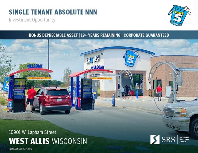
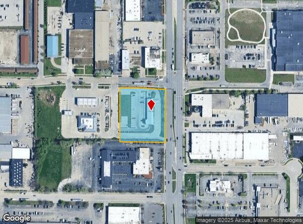
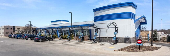
10809 W Lapham St
Milwaukee/Madison
Certified Survey Map No 9070
Milwaukee-Waukesha-West Allis, WI
THAT PART OF LOT 1, CERTIFIED SURVEY MAP 9070, AS DOCUMENT 10817185, IN THAT PART OF THE SOUTHEAST 1/4 OF THE NORTHEAST 1/2 OF SECTION 06, TOWN 06 NORTH, RANGE 21 EAST, IN THE CITY OF WEST ALLIS, MILWAUKEE COUNTY, WISCONSIN
448-9979-015
Milwaukee
Commercialnec
Wisconsin
2024
1
2024
1.88 AC
100400
West Allis
DEMOGRAPHICS near 10809 W Lapham St
1 Mile
3 Mile
5 Mile
2024 Total Population
10,298
106,512
286,268
2029 Population
10,035
105,441
283,431
Pop Growth 2024-2029
(2.55%)
(1.01%)
(0.99%)
Average Age
41
42
40
2024 Total Households
4,889
47,920
124,075
HH Growth 2024-2029
(2.62%)
(1.05%)
(1.06%)
Median Household Inc
$63,897
$68,720
$72,893
Avg Household Size
2.10
2.10
2.20
2024 Avg HH Vehicles
2.00
2.00
2.00
Median Home Value
$155,168
$218,012
$236,475
Median Year Built
1959
1958
1957
Nearby Places
Map Layers
Map Styles
 Street
 Aerial
- Restaurants
- Banks
- Shops
- Fitness
- Groceries
PUBLIC TRANSPORTATION
COMMUTER RAIL
Milwaukee (Empire Builder - Amtrak)
DRIVE
WALK
Distance
Milwaukee (Empire Builder - Amtrak)
14 min
7.7 mi
AIRPORT
General Mitchell International
DRIVE
WALK
Distance
General Mitchell International
22 min
12.3 mi
Freight Ports
Port Milwaukee
DRIVE
WALK
Distance
Port Milwaukee
18 min
10.2 mi
Nearby Properties
Address
Land Use
TOTAL SIZE
Lot Size
Zoning
Address
Land Use
TOTAL SIZE
Lot Size
Zoning
8.63 AC
C2
Address
Land Use
TOTAL SIZE
Lot Size
Zoning
36.11 AC
Address
Land Use
TOTAL SIZE
Lot Size
Zoning
Address
Land Use
TOTAL SIZE
Lot Size
Zoning
23.16 AC
Address
Land Use
TOTAL SIZE
Lot Size
Zoning
4.54 AC
Address
Land Use
TOTAL SIZE
Lot Size
Zoning
20.36 AC
Address
Land Use
TOTAL SIZE
Lot Size
Zoning
13.48 AC
Address
Land Use
TOTAL SIZE
Lot Size
Zoning
5.12 AC
Address
Land Use
TOTAL SIZE
Lot Size
Zoning
Address
Land Use
TOTAL SIZE
Lot Size
Zoning
10.22 AC
SP-RP
Address
Land Use
TOTAL SIZE
Lot Size
Zoning
234,132 SF
22.70 AC
RM1
Address
Land Use
TOTAL SIZE
Lot Size
Zoning
Address
Land Use
TOTAL SIZE
Lot Size
Zoning
8,881 SF
7.52 AC
Address
Land Use
TOTAL SIZE
Lot Size
Zoning
13.39 AC
Address
Land Use
TOTAL SIZE
Lot Size
Zoning
10.92 AC
Address
Land Use
TOTAL SIZE
Lot Size
Zoning
16.84 AC
Address
Land Use
TOTAL SIZE
Lot Size
Zoning
2.13 AC
SP-MED
Address
Land Use
TOTAL SIZE
Lot Size
Zoning
Address
Land Use
TOTAL SIZE
Lot Size
Zoning
29,664 SF
1.83 AC
C2
Address
Land Use
TOTAL SIZE
Lot Size
Zoning
5.27 AC
C2
Address
Land Use
TOTAL SIZE
Lot Size
Zoning
Address
Land Use
TOTAL SIZE
Lot Size
Zoning
Address
Land Use
TOTAL SIZE
Lot Size
Zoning
16.20 AC
Address
Land Use
TOTAL SIZE
Lot Size
Zoning
7.55 AC
SP-RP
Address
Land Use
TOTAL SIZE
Lot Size
Zoning
Address
Land Use
TOTAL SIZE
Lot Size
Zoning
Address
Land Use
TOTAL SIZE
Lot Size
Zoning
152,292 SF
15.79 AC
B1
Address
Land Use
TOTAL SIZE
Lot Size
Zoning
35.55 AC
INSTITUTIO
Address
Land Use
TOTAL SIZE
Lot Size
Zoning
158,246 SF
11.34 AC
RM1
Address
Land Use
TOTAL SIZE
Lot Size
Zoning
164,825 SF
7.93 AC
PD
The World's #1 Commercial Real Estate Marketplace
Connect with us
© 2025 CoStar Group
The information above has been obtained from sources believed reliable. While we do not doubt its accuracy we have not verified it and make no guarantee, warranty or representation about it. It is your responsibility to independently confirm its accuracy and completeness. Any projections, opinions, assumptions, or estimates used are for example only and do not represent the current or future performance of the property. The value of this transaction to you depends on tax and other factors which should be evaluated by your tax, financial, and legal advisors. You and your advisors should conduct a careful, independent investigation of the property to determine to your satisfaction the suitability of the property for your needs.