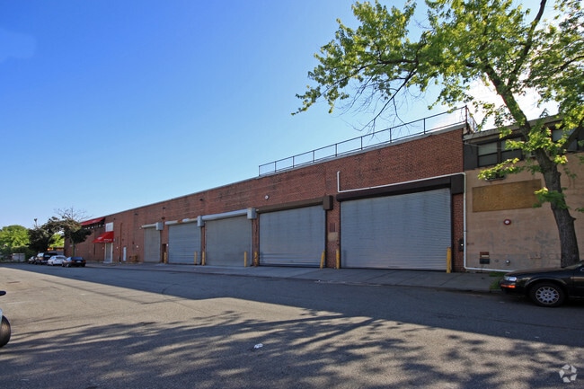
Property Record
10905 178Th St, Jamaica, NY 11433

NEARBY LISTINGS FOR SALE OR LEASE
Property Detail
10905 178Th St
10336-0160
Queens
Heavyindustrial
New York
X
160
3604970234F
1.18 AC
0
South Queens
2025
Long Island (New York)
041400
New York-Jersey City-White Plains, NY-NJ
51,324 SF
DEMOGRAPHICS near 10905 178Th St
1 Mile
3 Mile
5 Mile
2024 Total Population
71,059
584,252
1,300,029
2029 Population
65,719
542,523
1,214,149
Pop Growth 2024-2029
(7.51%)
(7.14%)
(6.61%)
Average Age
41
41
42
2024 Total Households
21,483
186,626
434,444
HH Growth 2024-2029
(7.87%)
(7.36%)
(6.78%)
Median Household Inc
$64,806
$75,778
$79,154
Avg Household Size
3.10
2.90
2.80
2024 Avg HH Vehicles
1.00
1.00
1.00
Median Home Value
$633,771
$639,859
$656,408
Median Year Built
1952
1951
1952
Nearby Places
- Restaurants
- Banks
- Shops
- Fitness
- Groceries
PUBLIC TRANSPORTATION
COMMUTER RAIL
Saint Albans Station (West Hempstead Branch - Long Island Rail Road)
DRIVE
WALK
Distance
Saint Albans Station (West Hempstead Branch - Long Island Rail Road)
4 min
18 min
0.9 mi
Hillside Facility (Hempstead Branch - Long Island Rail Road, Montauk Branch - Long Island Rail Road, Oyster Bay Branch - Long Island Rail Road, Port Jefferson Branch - Long Island Rail Road, Ronkonkoma Branch - Long Island Rail Road)
DRIVE
WALK
Distance
Hillside Facility (Hempstead Branch - Long Island Rail Road, Montauk Branch - Long Island Rail Road, Oyster Bay Branch - Long Island Rail Road, Port Jefferson Branch - Long Island Rail Road, Ronkonkoma Branch - Long Island Rail Road)
4 min
1.2 mi
AIRPORT
John F Kennedy International
DRIVE
WALK
Distance
John F Kennedy International
11 min
6.4 mi
LaGuardia
DRIVE
WALK
Distance
LaGuardia
18 min
9.5 mi
Newark Liberty International
DRIVE
WALK
Distance
Newark Liberty International
45 min
29.3 mi
Freight Ports
NY - Red Hook Container Terminal
DRIVE
WALK
Distance
NY - Red Hook Container Terminal
30 min
18.1 mi
SALE & LEASE HISTORY
LISTING DATE
SALE/LEASE

Mar 15, 2021
For Sale
Feb 05, 2024
For Sale
Nearby Properties
Address
Land Use
TOTAL SIZE
Lot Size
Zoning
Address
Land Use
TOTAL SIZE
Lot Size
Zoning
4,528,000 SF
94.27 AC
R4
Address
Land Use
TOTAL SIZE
Lot Size
Zoning
1,069,367 SF
14.65 AC
R4
Address
Land Use
TOTAL SIZE
Lot Size
Zoning
532,011 SF
2.48 AC
R6
Address
Land Use
TOTAL SIZE
Lot Size
Zoning
13,500 SF
104 AC
PARK
Address
Land Use
TOTAL SIZE
Lot Size
Zoning
731,247 SF
56.09 AC
R3-2
Address
Land Use
TOTAL SIZE
Lot Size
Zoning
947 SF
101.82 AC
PARK
Address
Land Use
TOTAL SIZE
Lot Size
Zoning
1,186,778 SF
31.45 AC
R4
Address
Land Use
TOTAL SIZE
Lot Size
Zoning
738,000 SF
1.92 AC
C6-3
Address
Land Use
TOTAL SIZE
Lot Size
Zoning
291,589 SF
1.55 AC
C6-3
Address
Land Use
TOTAL SIZE
Lot Size
Zoning
82.92 AC
PARK
Address
Land Use
TOTAL SIZE
Lot Size
Zoning
234,452 SF
2.99 AC
R4
Address
Land Use
TOTAL SIZE
Lot Size
Zoning
320,535 SF
1.52 AC
C4-4A
Address
Land Use
TOTAL SIZE
Lot Size
Zoning
377,896 SF
11.36 AC
R3-2
Address
Land Use
TOTAL SIZE
Lot Size
Zoning
384,249 SF
5.56 AC
R5
Address
Land Use
TOTAL SIZE
Lot Size
Zoning
364,424 SF
C5-3
Address
Land Use
TOTAL SIZE
Lot Size
Zoning
478,384 SF
1.23 AC
C6-3
Address
Land Use
TOTAL SIZE
Lot Size
Zoning
360,000 SF
8.78 AC
R6
Address
Land Use
TOTAL SIZE
Lot Size
Zoning
569,583 SF
2.28 AC
C4-5X
Address
Land Use
TOTAL SIZE
Lot Size
Zoning
230,580 SF
3.41 AC
C8-1
Address
Land Use
TOTAL SIZE
Lot Size
Zoning
614,916 SF
28.10 AC
R4
Address
Land Use
TOTAL SIZE
Lot Size
Zoning
460,540 SF
0.69 AC
C6-4
Address
Land Use
TOTAL SIZE
Lot Size
Zoning
535,609 SF
0.82 AC
C6-4
Address
Land Use
TOTAL SIZE
Lot Size
Zoning
208,952 SF
9.03 AC
M1-1
Address
Land Use
TOTAL SIZE
Lot Size
Zoning
107,000 SF
1.84 AC
R6
Address
Land Use
TOTAL SIZE
Lot Size
Zoning
348,320 SF
6.79 AC
C4-4
Address
Land Use
TOTAL SIZE
Lot Size
Zoning
1,400 SF
42.67 AC
PARK
Address
Land Use
TOTAL SIZE
Lot Size
Zoning
240,000 SF
14.50 AC
R4
Address
Land Use
TOTAL SIZE
Lot Size
Zoning
295,904 SF
0.63 AC
C6-3
Address
Land Use
TOTAL SIZE
Lot Size
Zoning
240,000 SF
1.91 AC
C6-3
Address
Land Use
TOTAL SIZE
Lot Size
Zoning
273,882 SF
2.90 AC
R4-1
The World's #1 Commercial Real Estate Marketplace
Connect with us
© 2025 CoStar Group
The information above has been obtained from sources believed reliable. While we do not doubt its accuracy we have not verified it and make no guarantee, warranty or representation about it. It is your responsibility to independently confirm its accuracy and completeness. Any projections, opinions, assumptions, or estimates used are for example only and do not represent the current or future performance of the property. The value of this transaction to you depends on tax and other factors which should be evaluated by your tax, financial, and legal advisors. You and your advisors should conduct a careful, independent investigation of the property to determine to your satisfaction the suitability of the property for your needs.