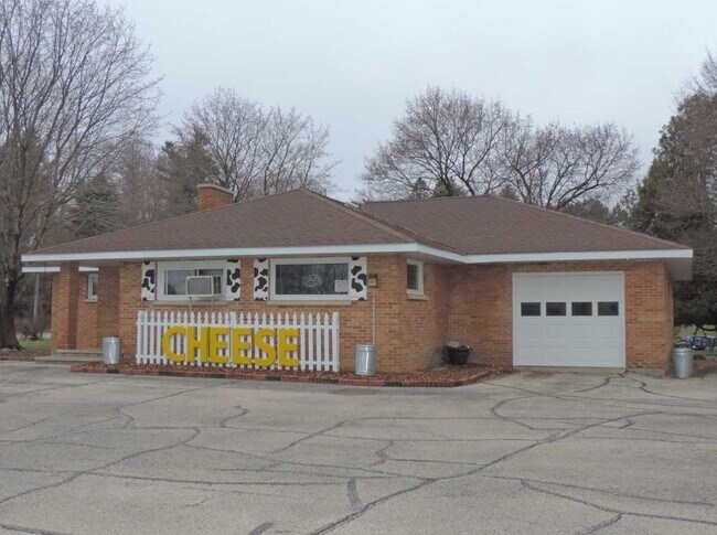
Property Record
10907 State Highway 32, Suring, WI 54174

Property Detail
10907 State Highway 32
010-16-16-022-44-C
PRT SESE E 200' OF S215'
Commercialnec
Oconto
GC
Wisconsin
B and X Area of moderate flood hazard, usually the area between the limits of the 100-year and 500-year floods.
1.18 AC
2025
Oconto County
2025
Green Bay
100600
Green Bay, WI
NEARBY LISTINGS FOR SALE OR LEASE
-
-
View all Suring listings for sale on LoopNet.com
DEMOGRAPHICS near 10907 State Highway 32
1 mile
3 mile
5 mile
2025 Total Population
80
788
1,808
2030 Population
82
801
1,876
Pop Growth 2025-2030
+ 2.50%
+ 1.65%
+ 3.76%
Average Age
45
45
47
2025 Total Households
35
327
804
HH Growth 2025-2030
0.00%
+ 1.53%
+ 3.98%
Median Household Inc
$72,499
$70,603
$60,097
Avg Household Size
2.20
2.40
2.20
2025 Avg HH Vehicles
2.00
2.00
2.00
Median Home Value
$177,777
$171,084
$182,010
Median Year Built
1972
1974
1977
Nearby Places
Map Layers
Map Styles
 Street
 Aerial
Layers
 Traffic
 Biking
Places
Listings with unknown addresses are not visible on the map
- Restaurants
- Banks
- Shops
- Fitness
- Groceries
SALE & LEASE HISTORY
LISTING DATE
SALE/LEASE

May 01, 2020
For Sale
Nearby Properties
Address
Land Use
TOTAL SIZE
Lot Size
Zoning
Address
Land Use
TOTAL SIZE
Lot Size
Zoning
32.35 AC
F
Address
Land Use
TOTAL SIZE
Lot Size
Zoning
1.77 AC
GC
Address
Land Use
TOTAL SIZE
Lot Size
Zoning
38.36 AC
AG
Address
Land Use
TOTAL SIZE
Lot Size
Zoning
2.61 AC
R1
Address
Land Use
TOTAL SIZE
Lot Size
Zoning
Address
Land Use
TOTAL SIZE
Lot Size
Zoning
40 AC
AG
Address
Land Use
TOTAL SIZE
Lot Size
Zoning
190.62 AC
R1
Address
Land Use
TOTAL SIZE
Lot Size
Zoning
Address
Land Use
TOTAL SIZE
Lot Size
Zoning
49.18 AC
F
Address
Land Use
TOTAL SIZE
Lot Size
Zoning
10.01 AC
AG
Address
Land Use
TOTAL SIZE
Lot Size
Zoning
2.50 AC
GC
Address
Land Use
TOTAL SIZE
Lot Size
Zoning
24.88 AC
AG
Address
Land Use
TOTAL SIZE
Lot Size
Zoning
40 AC
AG
Address
Land Use
TOTAL SIZE
Lot Size
Zoning
79.20 AC
F
Address
Land Use
TOTAL SIZE
Lot Size
Zoning
15.62 AC
Address
Land Use
TOTAL SIZE
Lot Size
Zoning
36.57 AC
F
Address
Land Use
TOTAL SIZE
Lot Size
Zoning
Address
Land Use
TOTAL SIZE
Lot Size
Zoning
4.11 AC
GC
Address
Land Use
TOTAL SIZE
Lot Size
Zoning
10.01 AC
Address
Land Use
TOTAL SIZE
Lot Size
Zoning
34.98 AC
F
Address
Land Use
TOTAL SIZE
Lot Size
Zoning
36.73 AC
F
Address
Land Use
TOTAL SIZE
Lot Size
Zoning
40 AC
RR
Address
Land Use
TOTAL SIZE
Lot Size
Zoning
30.13 AC
F
Address
Land Use
TOTAL SIZE
Lot Size
Zoning
Address
Land Use
TOTAL SIZE
Lot Size
Zoning
1.65 AC
F
Address
Land Use
TOTAL SIZE
Lot Size
Zoning
28.64 AC
Address
Land Use
TOTAL SIZE
Lot Size
Zoning
1.63 AC
R1
Address
Land Use
TOTAL SIZE
Lot Size
Zoning
15.23 AC
RC
Address
Land Use
TOTAL SIZE
Lot Size
Zoning
1.54 AC
F
The World's #1 Commercial Real Estate Marketplace
Connect with us
© 2026 CoStar Group
The information above has been obtained from sources believed reliable. While we do not doubt its accuracy we have not verified it and make no guarantee, warranty or representation about it. It is your responsibility to independently confirm its accuracy and completeness. Any projections, opinions, assumptions, or estimates used are for example only and do not represent the current or future performance of the property. The value of this transaction to you depends on tax and other factors which should be evaluated by your tax, financial, and legal advisors. You and your advisors should conduct a careful, independent investigation of the property to determine to your satisfaction the suitability of the property for your needs.