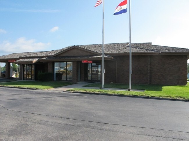
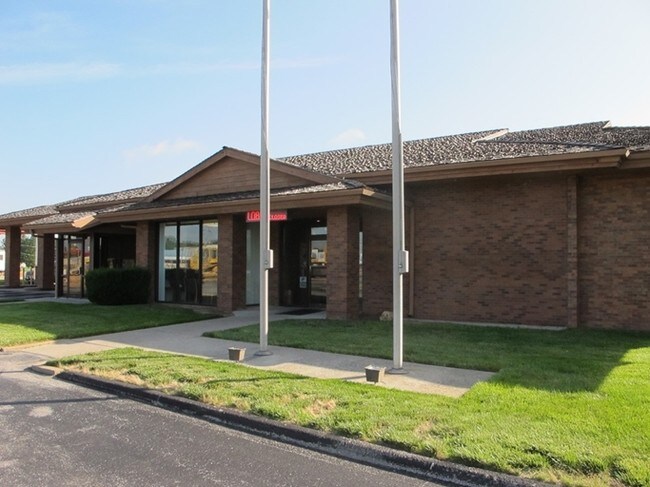
Property Record
1091 Spur Dr, Marshfield, MO 65706

Save to a Folder
{{folder.Name}}
{{folder.ListingIds.length}} Properties
{{folder.ListingIds.length}} Property
Create a New Folder
Property Detail
1091 Spur Dr
Springfield, MO
LT 2 BEAR BANK VILLAGE
112009002001008020
WEBSTER
Financialbuilding
Missouri
B and X Area of moderate flood hazard, usually the area between the limits of the 100-year and 500-year floods.
2
2025
1.11 AC
2025
Webster County
470202
Springfield
3,373 SF
NEARBY LISTINGS FOR SALE OR LEASE
DEMOGRAPHICS near 1091 Spur Dr
1 mile
3 mile
5 mile
2025 Total Population
4,014
9,976
13,277
2030 Population
4,243
10,612
14,134
Pop Growth 2025-2030
+ 5.71%
+ 6.38%
+ 6.45%
Average Age
40
39
40
2025 Total Households
1,632
3,911
5,164
HH Growth 2025-2030
+ 5.58%
+ 6.21%
+ 6.29%
Median Household Inc
$68,136
$68,893
$71,392
Avg Household Size
2.40
2.50
2.50
2025 Avg HH Vehicles
2.00
2.00
2.00
Median Home Value
$202,724
$219,477
$233,647
Median Year Built
1982
1983
1986
Nearby Places
Map Layers
Map Styles
 Street
 Aerial
Layers
 Traffic
 Biking
Places
Listings with unknown addresses are not visible on the map
- Restaurants
- Banks
- Shops
- Fitness
- Groceries
PUBLIC TRANSPORTATION
AIRPORT
Springfield-Branson Ntl
Drive
Walk
Distance
Springfield-Branson Ntl
43 min
32.2 mi
SALE & LEASE HISTORY
LISTING DATE
SALE/LEASE

Sep 24, 2016
For Sale
Nearby Properties
Address
Land Use
TOTAL SIZE
Lot Size
Zoning
Address
Land Use
TOTAL SIZE
Lot Size
Zoning
158,025 SF
24.63 AC
Address
Land Use
TOTAL SIZE
Lot Size
Zoning
15,716 SF
2.31 AC
Address
Land Use
TOTAL SIZE
Lot Size
Zoning
1,050 SF
38.55 AC
Address
Land Use
TOTAL SIZE
Lot Size
Zoning
36,080 SF
6.18 AC
Address
Land Use
TOTAL SIZE
Lot Size
Zoning
12,586 SF
2.35 AC
Address
Land Use
TOTAL SIZE
Lot Size
Zoning
13,824 SF
6.31 AC
Address
Land Use
TOTAL SIZE
Lot Size
Zoning
3,750 SF
12.35 AC
Address
Land Use
TOTAL SIZE
Lot Size
Zoning
31,780 SF
20 AC
Address
Land Use
TOTAL SIZE
Lot Size
Zoning
11,340 SF
23.12 AC
Address
Land Use
TOTAL SIZE
Lot Size
Zoning
1,904 SF
6.40 AC
Address
Land Use
TOTAL SIZE
Lot Size
Zoning
1,200 SF
5.76 AC
Address
Land Use
TOTAL SIZE
Lot Size
Zoning
15,827 SF
3.02 AC
Address
Land Use
TOTAL SIZE
Lot Size
Zoning
880 SF
51.61 AC
Address
Land Use
TOTAL SIZE
Lot Size
Zoning
42,480 SF
28.95 AC
Address
Land Use
TOTAL SIZE
Lot Size
Zoning
14,097 SF
1 AC
Address
Land Use
TOTAL SIZE
Lot Size
Zoning
39,693 SF
4 AC
Address
Land Use
TOTAL SIZE
Lot Size
Zoning
14,522 SF
2.13 AC
Address
Land Use
TOTAL SIZE
Lot Size
Zoning
4,320 SF
6.93 AC
Address
Land Use
TOTAL SIZE
Lot Size
Zoning
4,324 SF
129.79 AC
Address
Land Use
TOTAL SIZE
Lot Size
Zoning
30,391 SF
3 AC
Address
Land Use
TOTAL SIZE
Lot Size
Zoning
20,850 SF
5 AC
Address
Land Use
TOTAL SIZE
Lot Size
Zoning
10,699 SF
1.16 AC
Address
Land Use
TOTAL SIZE
Lot Size
Zoning
4,320 SF
3 AC
Address
Land Use
TOTAL SIZE
Lot Size
Zoning
9,800 SF
4.27 AC
Address
Land Use
TOTAL SIZE
Lot Size
Zoning
1,500 SF
4.95 AC
Address
Land Use
TOTAL SIZE
Lot Size
Zoning
7,012 SF
2.45 AC
Address
Land Use
TOTAL SIZE
Lot Size
Zoning
1,980 SF
7.14 AC
Address
Land Use
TOTAL SIZE
Lot Size
Zoning
120 SF
4.22 AC
Address
Land Use
TOTAL SIZE
Lot Size
Zoning
18,510 SF
4.02 AC
Address
Land Use
TOTAL SIZE
Lot Size
Zoning
8,378 SF
2.11 AC
The World's #1 Commercial Real Estate Marketplace
Connect with us
© 2026 CoStar Group
The information above has been obtained from sources believed reliable. While we do not doubt its accuracy we have not verified it and make no guarantee, warranty or representation about it. It is your responsibility to independently confirm its accuracy and completeness. Any projections, opinions, assumptions, or estimates used are for example only and do not represent the current or future performance of the property. The value of this transaction to you depends on tax and other factors which should be evaluated by your tax, financial, and legal advisors. You and your advisors should conduct a careful, independent investigation of the property to determine to your satisfaction the suitability of the property for your needs.