Property Record
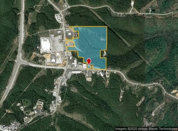
10921 E State Highway 76, Reeds Spring, MO 65737
NEARBY LISTINGS FOR SALE OR LEASE
Property Detail
10921 E State Highway 76
Branson, MO
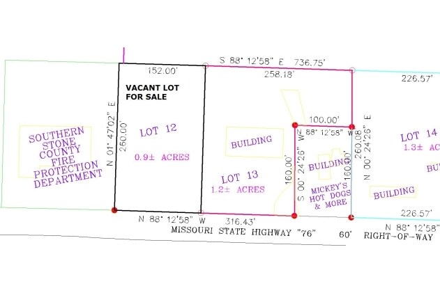
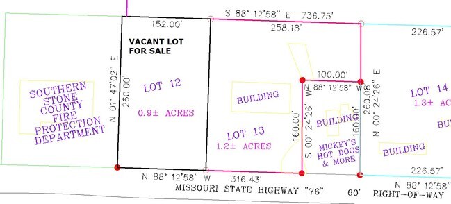
Silver Thread Dev Ph 1
11-6.0-13-000-000-001.002
, LOTS 1 AND SILVER THREAD DEV PH II, LOTS 13, 14, 15 & 16 ALSO THE PT OF NE LYING N OF HWY 76 & E OF 13/76 DESC AS BEG AT NE OF SEC 13, S 1090, W 250, S 325, E 250, S 630, W 975, N 490, W 195, N 250, W 465, NW 1230, E 1850 TO POB
Restaurantdrivein
Stone
X
Missouri
29209C0205D
1,3,4
2024
51.05 AC
2025
Branson
090603
Other Market Areas
5,912 SF
DEMOGRAPHICS near 10921 E State Highway 76
1 Mile
3 Mile
5 Mile
2024 Total Population
127
3,522
9,506
2029 Population
137
3,894
10,395
Pop Growth 2024-2029
+ 7.87%
+ 10.56%
+ 9.35%
Average Age
46
48
48
2024 Total Households
52
1,515
4,066
HH Growth 2024-2029
+ 7.69%
+ 10.17%
+ 9.00%
Median Household Inc
$47,500
$54,559
$54,903
Avg Household Size
2.40
2.30
2.30
2024 Avg HH Vehicles
2.00
2.00
2.00
Median Home Value
$173,076
$204,580
$208,403
Median Year Built
1997
1998
1994
Nearby Places
Map Layers
Map Styles
 Street
 Aerial
- Restaurants
- Banks
- Shops
- Fitness
- Groceries
SALE & LEASE HISTORY
LISTING DATE
SALE/LEASE

Sep 24, 2016
For Sale
Nearby Properties
Address
Land Use
TOTAL SIZE
Lot Size
Zoning
Address
Land Use
TOTAL SIZE
Lot Size
Zoning
20,182 SF
160.11 AC
C-2
Address
Land Use
TOTAL SIZE
Lot Size
Zoning
108,452 SF
47.84 AC
A-1
Address
Land Use
TOTAL SIZE
Lot Size
Zoning
153,535 SF
18.72 AC
NA
Address
Land Use
TOTAL SIZE
Lot Size
Zoning
26,445 SF
104.70 AC
A-1
Address
Land Use
TOTAL SIZE
Lot Size
Zoning
19,186 SF
172.04 AC
C-2
Address
Land Use
TOTAL SIZE
Lot Size
Zoning
6,000 SF
11.93 AC
NA
Address
Land Use
TOTAL SIZE
Lot Size
Zoning
58,080 SF
6.81 AC
C-2
Address
Land Use
TOTAL SIZE
Lot Size
Zoning
44,979 SF
12.80 AC
NA
Address
Land Use
TOTAL SIZE
Lot Size
Zoning
74,763 SF
28.27 AC
NA
Address
Land Use
TOTAL SIZE
Lot Size
Zoning
7,088 SF
1.98 AC
C-2
Address
Land Use
TOTAL SIZE
Lot Size
Zoning
14,748 SF
1.60 AC
NA
Address
Land Use
TOTAL SIZE
Lot Size
Zoning
77,252 SF
36.08 AC
A-1
Address
Land Use
TOTAL SIZE
Lot Size
Zoning
15,000 SF
2.32 AC
NA
Address
Land Use
TOTAL SIZE
Lot Size
Zoning
93,998 SF
39 AC
NA
Address
Land Use
TOTAL SIZE
Lot Size
Zoning
23,640 SF
29.64 AC
NA
Address
Land Use
TOTAL SIZE
Lot Size
Zoning
92,520 SF
Address
Land Use
TOTAL SIZE
Lot Size
Zoning
25,052 SF
3.98 AC
NA
Address
Land Use
TOTAL SIZE
Lot Size
Zoning
11,860 SF
5.40 AC
C-2
Address
Land Use
TOTAL SIZE
Lot Size
Zoning
36,558 SF
7.60 AC
NA
Address
Land Use
TOTAL SIZE
Lot Size
Zoning
8,100 SF
1.13 AC
Address
Land Use
TOTAL SIZE
Lot Size
Zoning
8,915 SF
3.27 AC
C-2
Address
Land Use
TOTAL SIZE
Lot Size
Zoning
400,000 SF
0.04 AC
Address
Land Use
TOTAL SIZE
Lot Size
Zoning
6,000 SF
0.87 AC
Address
Land Use
TOTAL SIZE
Lot Size
Zoning
46,225 SF
Address
Land Use
TOTAL SIZE
Lot Size
Zoning
3,520 SF
1.30 AC
Address
Land Use
TOTAL SIZE
Lot Size
Zoning
4,335 SF
0.90 AC
RR-1
Address
Land Use
TOTAL SIZE
Lot Size
Zoning
3,702 SF
36.98 AC
C-2
Address
Land Use
TOTAL SIZE
Lot Size
Zoning
13,979 SF
68 AC
C-2
The World's #1 Commercial Real Estate Marketplace
Connect with us
© 2025 CoStar Group
The information above has been obtained from sources believed reliable. While we do not doubt its accuracy we have not verified it and make no guarantee, warranty or representation about it. It is your responsibility to independently confirm its accuracy and completeness. Any projections, opinions, assumptions, or estimates used are for example only and do not represent the current or future performance of the property. The value of this transaction to you depends on tax and other factors which should be evaluated by your tax, financial, and legal advisors. You and your advisors should conduct a careful, independent investigation of the property to determine to your satisfaction the suitability of the property for your needs.