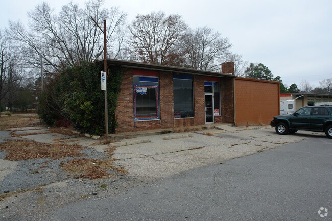
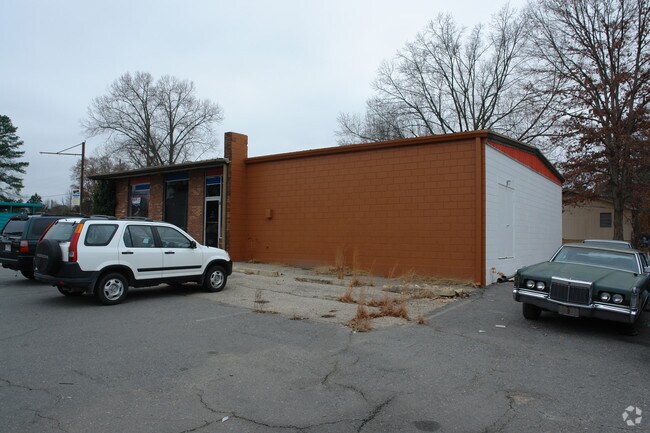
Property Record
10915 High Rd, Mabelvale, AR 72103

Property Detail
10915 High Rd
Little Rock-North Little Rock-Conway, AR
2010-10528
880-01541-000
SALINE
Storebuilding
Arkansas
B and X Area of moderate flood hazard, usually the area between the limits of the 100-year and 500-year floods.
7
2025
0.23 AC
2025
Saline County
010409
Little Rock/N Little Rock
2,460 SF
NEARBY LISTINGS FOR SALE OR LEASE
DEMOGRAPHICS near 10915 High Rd
1 mile
3 mile
5 mile
2025 Total Population
2,414
19,943
62,648
2030 Population
2,517
20,588
64,181
Pop Growth 2025-2030
+ 4.27%
+ 3.23%
+ 2.45%
Average Age
40
37
37
2025 Total Households
919
7,479
24,140
HH Growth 2025-2030
+ 4.24%
+ 3.28%
+ 2.39%
Median Household Inc
$52,500
$59,713
$57,514
Avg Household Size
2.60
2.60
2.50
2025 Avg HH Vehicles
2.00
2.00
2.00
Median Home Value
$166,917
$163,975
$167,326
Median Year Built
1983
1988
1988
Nearby Places
Map Layers
Map Styles
 Street
 Aerial
Layers
 Traffic
 Biking
Places
Listings with unknown addresses are not visible on the map
- Restaurants
- Banks
- Shops
- Fitness
- Groceries
PUBLIC TRANSPORTATION
AIRPORT
Bill and Hillary Clinton Ntl/Adams Field
Drive
Walk
Distance
Bill and Hillary Clinton Ntl/Adams Field
24 min
15.1 mi
Nearby Properties
Address
Land Use
TOTAL SIZE
Lot Size
Zoning
Address
Land Use
TOTAL SIZE
Lot Size
Zoning
189,729 SF
57.75 AC
Address
Land Use
TOTAL SIZE
Lot Size
Zoning
177,413 SF
35.78 AC
Address
Land Use
TOTAL SIZE
Lot Size
Zoning
185,805 SF
8.29 AC
Address
Land Use
TOTAL SIZE
Lot Size
Zoning
317,302 SF
44.38 AC
Address
Land Use
TOTAL SIZE
Lot Size
Zoning
201,039 SF
146.98 AC
Address
Land Use
TOTAL SIZE
Lot Size
Zoning
365,104 SF
29.75 AC
Address
Land Use
TOTAL SIZE
Lot Size
Zoning
104,359 SF
14.63 AC
Address
Land Use
TOTAL SIZE
Lot Size
Zoning
7,937 SF
5.50 AC
Address
Land Use
TOTAL SIZE
Lot Size
Zoning
12,420 SF
12.25 AC
Address
Land Use
TOTAL SIZE
Lot Size
Zoning
8,510 SF
13.20 AC
Address
Land Use
TOTAL SIZE
Lot Size
Zoning
45,600 SF
6.45 AC
Address
Land Use
TOTAL SIZE
Lot Size
Zoning
189,160 SF
40.53 AC
Address
Land Use
TOTAL SIZE
Lot Size
Zoning
30,356 SF
5.42 AC
Address
Land Use
TOTAL SIZE
Lot Size
Zoning
11,762 SF
9.05 AC
Address
Land Use
TOTAL SIZE
Lot Size
Zoning
309,271 SF
41.75 AC
Address
Land Use
TOTAL SIZE
Lot Size
Zoning
7,482 SF
6.58 AC
Address
Land Use
TOTAL SIZE
Lot Size
Zoning
6,282 SF
61.51 AC
Address
Land Use
TOTAL SIZE
Lot Size
Zoning
162,970 SF
12.66 AC
Address
Land Use
TOTAL SIZE
Lot Size
Zoning
54.01 AC
Address
Land Use
TOTAL SIZE
Lot Size
Zoning
103,722 SF
11.88 AC
Address
Land Use
TOTAL SIZE
Lot Size
Zoning
6,048 SF
10.23 AC
Address
Land Use
TOTAL SIZE
Lot Size
Zoning
17,700 SF
6.87 AC
Address
Land Use
TOTAL SIZE
Lot Size
Zoning
38,647 SF
1.78 AC
Address
Land Use
TOTAL SIZE
Lot Size
Zoning
95,820 SF
9.86 AC
Address
Land Use
TOTAL SIZE
Lot Size
Zoning
39,600 SF
5.49 AC
Address
Land Use
TOTAL SIZE
Lot Size
Zoning
14,520 SF
12.64 AC
Address
Land Use
TOTAL SIZE
Lot Size
Zoning
7.44 AC
Address
Land Use
TOTAL SIZE
Lot Size
Zoning
100,000 SF
6.86 AC
Address
Land Use
TOTAL SIZE
Lot Size
Zoning
13,486 SF
1.12 AC
Address
Land Use
TOTAL SIZE
Lot Size
Zoning
103,492 SF
9.67 AC
The World's #1 Commercial Real Estate Marketplace
Connect with us
© 2026 CoStar Group
The information above has been obtained from sources believed reliable. While we do not doubt its accuracy we have not verified it and make no guarantee, warranty or representation about it. It is your responsibility to independently confirm its accuracy and completeness. Any projections, opinions, assumptions, or estimates used are for example only and do not represent the current or future performance of the property. The value of this transaction to you depends on tax and other factors which should be evaluated by your tax, financial, and legal advisors. You and your advisors should conduct a careful, independent investigation of the property to determine to your satisfaction the suitability of the property for your needs.