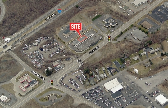
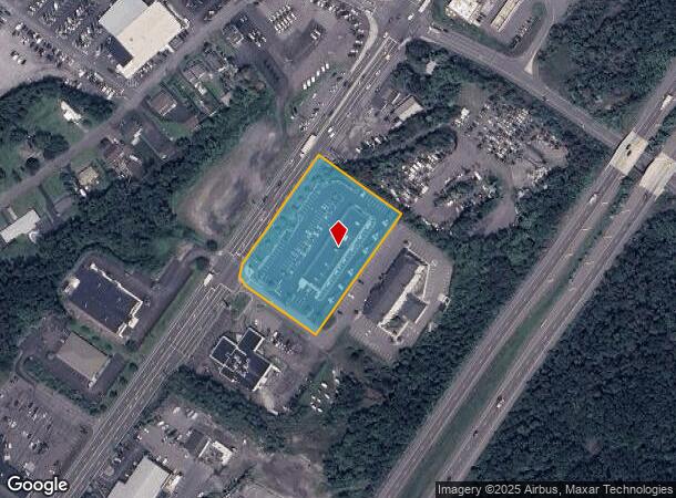
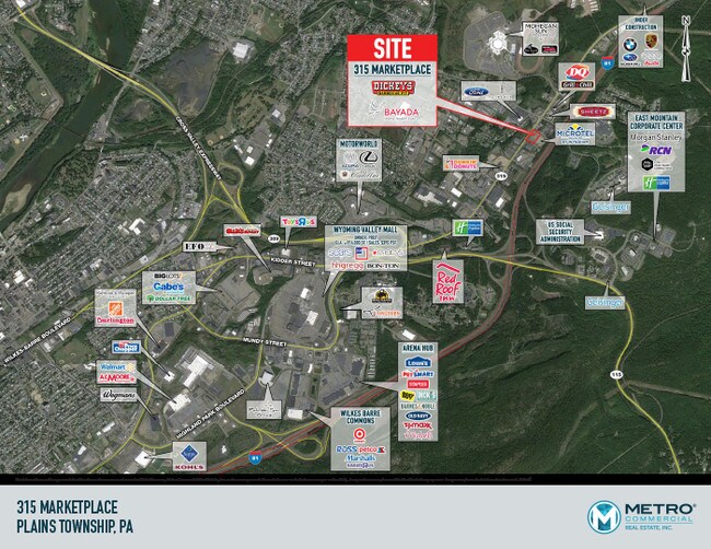
Property Record
1189 Highway 315 Blvd, Wilkes Barre, PA 18702
NEARBY LISTINGS FOR SALE OR LEASE
Property Detail
1189 Highway 315 Blvd
Scranton--Wilkes-Barre--Hazelton, PA
315 Marketplace
50-G11S1-003-017-000
50-C-62-R10-D1-3 ADJ FOX 56
Commercialnec
Luzerne
X
Pennsylvania
42079C0239E
17
2025
2.14 AC
2025
I-81 Corridor
211800
Philadelphia
DEMOGRAPHICS near 1189 Highway 315 Blvd
1 Mile
3 Mile
5 Mile
2024 Total Population
2,031
26,216
113,986
2029 Population
2,005
25,994
113,793
Pop Growth 2024-2029
(1.28%)
(0.85%)
(0.17%)
Average Age
48
44
41
2024 Total Households
920
11,511
49,052
HH Growth 2024-2029
(1.41%)
(0.93%)
(0.22%)
Median Household Inc
$58,245
$58,017
$53,577
Avg Household Size
2.00
2.20
2.20
2024 Avg HH Vehicles
2.00
2.00
2.00
Median Home Value
$139,083
$123,337
$125,371
Median Year Built
1980
1951
1950
Nearby Places
- Restaurants
- Banks
- Shops
- Fitness
- Groceries
PUBLIC TRANSPORTATION
AIRPORT
Wilkes-Barre/Scranton International
DRIVE
WALK
Distance
Wilkes-Barre/Scranton International
14 min
7.7 mi
Freight Ports
Maher Terminal
DRIVE
WALK
Distance
Maher Terminal
152 min
118.7 mi
SALE & LEASE HISTORY
LISTING DATE
SALE/LEASE

Nov 17, 2016
For Lease
Nearby Properties
Address
Land Use
TOTAL SIZE
Lot Size
Zoning
Address
Land Use
TOTAL SIZE
Lot Size
Zoning
29.42 AC
Address
Land Use
TOTAL SIZE
Lot Size
Zoning
263.92 AC
Address
Land Use
TOTAL SIZE
Lot Size
Zoning
Address
Land Use
TOTAL SIZE
Lot Size
Zoning
50.81 AC
Address
Land Use
TOTAL SIZE
Lot Size
Zoning
225.55 AC
Address
Land Use
TOTAL SIZE
Lot Size
Zoning
132.36 AC
Address
Land Use
TOTAL SIZE
Lot Size
Zoning
46.26 AC
Address
Land Use
TOTAL SIZE
Lot Size
Zoning
44.09 AC
Address
Land Use
TOTAL SIZE
Lot Size
Zoning
80.97 AC
Address
Land Use
TOTAL SIZE
Lot Size
Zoning
Address
Land Use
TOTAL SIZE
Lot Size
Zoning
4.08 AC
Address
Land Use
TOTAL SIZE
Lot Size
Zoning
30.02 AC
Address
Land Use
TOTAL SIZE
Lot Size
Zoning
37.94 AC
Address
Land Use
TOTAL SIZE
Lot Size
Zoning
12.25 AC
Address
Land Use
TOTAL SIZE
Lot Size
Zoning
Address
Land Use
TOTAL SIZE
Lot Size
Zoning
14.33 AC
Address
Land Use
TOTAL SIZE
Lot Size
Zoning
11.69 AC
Address
Land Use
TOTAL SIZE
Lot Size
Zoning
Address
Land Use
TOTAL SIZE
Lot Size
Zoning
55.45 AC
Address
Land Use
TOTAL SIZE
Lot Size
Zoning
Address
Land Use
TOTAL SIZE
Lot Size
Zoning
77.69 AC
Address
Land Use
TOTAL SIZE
Lot Size
Zoning
7.74 AC
Address
Land Use
TOTAL SIZE
Lot Size
Zoning
43.01 AC
Address
Land Use
TOTAL SIZE
Lot Size
Zoning
12.60 AC
Address
Land Use
TOTAL SIZE
Lot Size
Zoning
Address
Land Use
TOTAL SIZE
Lot Size
Zoning
Address
Land Use
TOTAL SIZE
Lot Size
Zoning
9,437 AC
Address
Land Use
TOTAL SIZE
Lot Size
Zoning
Address
Land Use
TOTAL SIZE
Lot Size
Zoning
Address
Land Use
TOTAL SIZE
Lot Size
Zoning
The World's #1 Commercial Real Estate Marketplace
Connect with us
© 2025 CoStar Group
The information above has been obtained from sources believed reliable. While we do not doubt its accuracy we have not verified it and make no guarantee, warranty or representation about it. It is your responsibility to independently confirm its accuracy and completeness. Any projections, opinions, assumptions, or estimates used are for example only and do not represent the current or future performance of the property. The value of this transaction to you depends on tax and other factors which should be evaluated by your tax, financial, and legal advisors. You and your advisors should conduct a careful, independent investigation of the property to determine to your satisfaction the suitability of the property for your needs.