Property Record
10920 Stellhorn Rd, New Haven, IN 46774
NEARBY LISTINGS FOR SALE OR LEASE
-
-
View all New Haven listings for lease on LoopNet.com
Property Detail
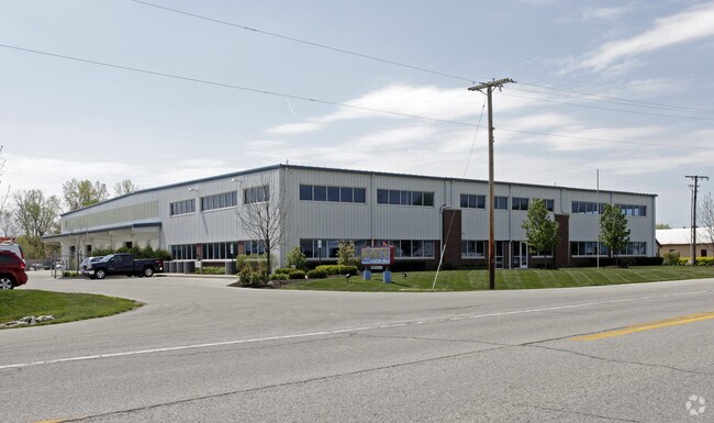
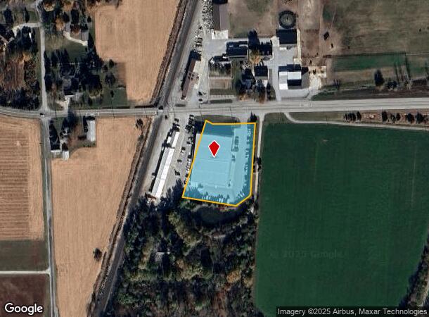
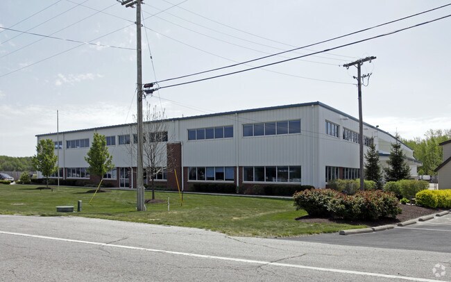
10920 Stellhorn Rd
02-09-30-100-004.001-097
2.00 A IRR TR 128.58 FT E OF E R/W LINE OF RR FRL NW 1/4 NW 1/4 SEC 30
Warehouse
Allen
X
Indiana
18003C0307G
2 AC
2023
Outlying Allen County
2024
Fort Wayne
010900
Fort Wayne, IN
30,725 SF
DEMOGRAPHICS near 10920 Stellhorn Rd
1 Mile
3 Mile
5 Mile
2024 Total Population
853
25,395
74,179
2029 Population
882
26,202
76,607
Pop Growth 2024-2029
+ 3.40%
+ 3.18%
+ 3.27%
Average Age
42
41
40
2024 Total Households
372
9,952
29,790
HH Growth 2024-2029
+ 3.76%
+ 3.26%
+ 3.33%
Median Household Inc
$74,999
$77,500
$67,518
Avg Household Size
2.30
2.50
2.40
2024 Avg HH Vehicles
2.00
2.00
2.00
Median Home Value
$181,007
$186,406
$165,210
Median Year Built
1993
1986
1976
Nearby Places
Map Layers
Map Styles
 Street
 Aerial
- Restaurants
- Banks
- Shops
- Fitness
- Groceries
PUBLIC TRANSPORTATION
AIRPORT
Fort Wayne International
DRIVE
WALK
Distance
Fort Wayne International
36 min
19.6 mi
Freight Ports
Port of Toledo
DRIVE
WALK
Distance
Port of Toledo
126 min
96.6 mi
SALE & LEASE HISTORY
LISTING DATE
SALE/LEASE

Sep 25, 2016
For Lease
Jan 04, 2017
For Lease
Nearby Properties
Address
Land Use
TOTAL SIZE
Lot Size
Zoning
Address
Land Use
TOTAL SIZE
Lot Size
Zoning
298,087 SF
24.54 AC
Address
Land Use
TOTAL SIZE
Lot Size
Zoning
144,297 SF
19.16 AC
Address
Land Use
TOTAL SIZE
Lot Size
Zoning
25,272 SF
2.58 AC
Address
Land Use
TOTAL SIZE
Lot Size
Zoning
206,618 SF
21.20 AC
Address
Land Use
TOTAL SIZE
Lot Size
Zoning
210,230 SF
35.30 AC
Address
Land Use
TOTAL SIZE
Lot Size
Zoning
169,740 SF
30.62 AC
Address
Land Use
TOTAL SIZE
Lot Size
Zoning
72,240 SF
9.41 AC
Address
Land Use
TOTAL SIZE
Lot Size
Zoning
126,495 SF
9.28 AC
Address
Land Use
TOTAL SIZE
Lot Size
Zoning
145,580 SF
8.15 AC
Address
Land Use
TOTAL SIZE
Lot Size
Zoning
94,015 SF
9.45 AC
Address
Land Use
TOTAL SIZE
Lot Size
Zoning
24,612 SF
5.83 AC
Address
Land Use
TOTAL SIZE
Lot Size
Zoning
79,707 SF
11.53 AC
Address
Land Use
TOTAL SIZE
Lot Size
Zoning
105,868 SF
13.42 AC
Address
Land Use
TOTAL SIZE
Lot Size
Zoning
106,164 SF
10.34 AC
Address
Land Use
TOTAL SIZE
Lot Size
Zoning
118,956 SF
36.27 AC
Address
Land Use
TOTAL SIZE
Lot Size
Zoning
96,315 SF
8.33 AC
Address
Land Use
TOTAL SIZE
Lot Size
Zoning
16,250 SF
2.02 AC
Address
Land Use
TOTAL SIZE
Lot Size
Zoning
123,852 SF
9.40 AC
Address
Land Use
TOTAL SIZE
Lot Size
Zoning
56,443 SF
10.41 AC
Address
Land Use
TOTAL SIZE
Lot Size
Zoning
96,347 SF
8.80 AC
Address
Land Use
TOTAL SIZE
Lot Size
Zoning
87,726 SF
7.63 AC
Address
Land Use
TOTAL SIZE
Lot Size
Zoning
67,800 SF
6.12 AC
Address
Land Use
TOTAL SIZE
Lot Size
Zoning
79,856 SF
8.63 AC
Address
Land Use
TOTAL SIZE
Lot Size
Zoning
15,546 SF
1.85 AC
Address
Land Use
TOTAL SIZE
Lot Size
Zoning
80,064 SF
10.24 AC
Address
Land Use
TOTAL SIZE
Lot Size
Zoning
35,159 SF
3.78 AC
Address
Land Use
TOTAL SIZE
Lot Size
Zoning
13,920 SF
1.55 AC
Address
Land Use
TOTAL SIZE
Lot Size
Zoning
16.04 AC
Address
Land Use
TOTAL SIZE
Lot Size
Zoning
61,240 SF
23.28 AC
Address
Land Use
TOTAL SIZE
Lot Size
Zoning
35,498 SF
11.47 AC
The World's #1 Commercial Real Estate Marketplace
Connect with us
© 2025 CoStar Group
The information above has been obtained from sources believed reliable. While we do not doubt its accuracy we have not verified it and make no guarantee, warranty or representation about it. It is your responsibility to independently confirm its accuracy and completeness. Any projections, opinions, assumptions, or estimates used are for example only and do not represent the current or future performance of the property. The value of this transaction to you depends on tax and other factors which should be evaluated by your tax, financial, and legal advisors. You and your advisors should conduct a careful, independent investigation of the property to determine to your satisfaction the suitability of the property for your needs.