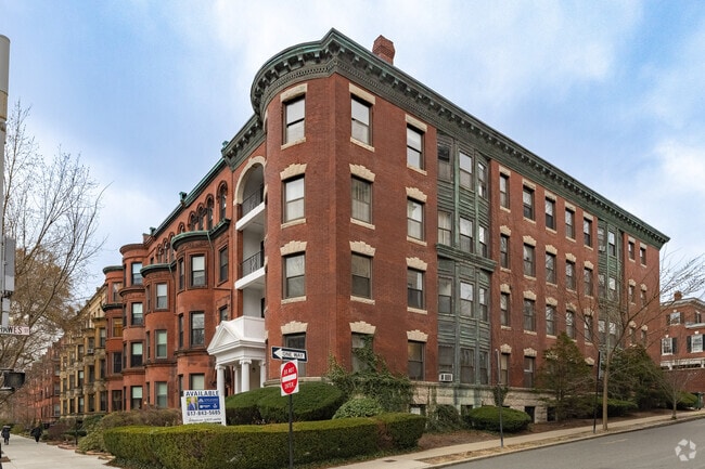
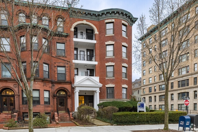
Property Record
1093 Beacon St, Brookline, MA 02446
NEARBY LISTINGS FOR SALE OR LEASE
Property Detail
1093 Beacon St
BROO-000116-000005
Brookline
Officebuilding
Norfolk
X
Massachusetts
25021C0051F
5
2025
0.12 AC
2025
Newton/Brookline
400100
Boston
11,320 SF
Boston-Cambridge-Newton, MA-NH
DEMOGRAPHICS near 1093 Beacon St
1 Mile
3 Mile
5 Mile
2024 Total Population
73,200
488,113
964,405
2029 Population
71,578
472,872
931,495
Pop Growth 2024-2029
(2.22%)
(3.12%)
(3.41%)
Average Age
33
36
37
2024 Total Households
29,165
208,151
403,179
HH Growth 2024-2029
(2.39%)
(3.34%)
(3.63%)
Median Household Inc
$72,012
$88,464
$97,028
Avg Household Size
2.00
2.00
2.20
2024 Avg HH Vehicles
1.00
1.00
1.00
Median Home Value
$1,008,318
$907,131
$829,886
Median Year Built
1957
1951
1949
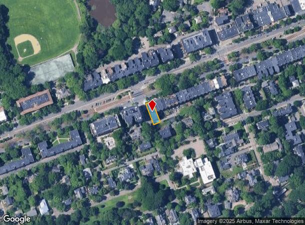
Nearby Places
Map Layers
Map Styles
 Street
 Aerial
- Restaurants
- Banks
- Shops
- Fitness
- Groceries
PUBLIC TRANSPORTATION
TRANSIT/SUBWAY
Hawes Street Station (Green Line - C - Massachusetts Bay Transportation Authority Subway (The T))
DRIVE
WALK
Distance
Hawes Street Station (Green Line - C - Massachusetts Bay Transportation Authority Subway (The T))
1 min
1 min
0.0 mi
St Mary's Street Station (Green Line - C - Massachusetts Bay Transportation Authority Subway (The T))
DRIVE
WALK
Distance
St Mary's Street Station (Green Line - C - Massachusetts Bay Transportation Authority Subway (The T))
0 min
5 min
0.2 mi
Kent Street Station (Green Line - C - Massachusetts Bay Transportation Authority Subway (The T))
DRIVE
WALK
Distance
Kent Street Station (Green Line - C - Massachusetts Bay Transportation Authority Subway (The T))
1 min
4 min
0.2 mi
Longwood Station (Green Line - D - Massachusetts Bay Transportation Authority Subway (The T))
DRIVE
WALK
Distance
Longwood Station (Green Line - D - Massachusetts Bay Transportation Authority Subway (The T))
1 min
5 min
0.3 mi
Fenway Station (Green Line - D - Massachusetts Bay Transportation Authority Subway (The T))
DRIVE
WALK
Distance
Fenway Station (Green Line - D - Massachusetts Bay Transportation Authority Subway (The T))
1 min
9 min
0.4 mi
COMMUTER RAIL
Yawkey (Framingham/Worcester Line - Massachusetts Bay Transportation Authority Commuter Rail (Purple Line))
DRIVE
WALK
Distance
Yawkey (Framingham/Worcester Line - Massachusetts Bay Transportation Authority Commuter Rail (Purple Line))
8 min
11 min
0.6 mi
Ruggles Station (Orange Line - Massachusetts Bay Transportation Authority Subway (The T))
DRIVE
WALK
Distance
Ruggles Station (Orange Line - Massachusetts Bay Transportation Authority Subway (The T))
4 min
1.7 mi
AIRPORT
General Edward Lawrence Logan International
DRIVE
WALK
Distance
General Edward Lawrence Logan International
16 min
6.7 mi
Freight Ports
Port of Boston
DRIVE
WALK
Distance
Port of Boston
13 min
5.9 mi
SALE & LEASE HISTORY
LISTING DATE
SALE/LEASE

Sep 25, 2016
For Lease
Oct 26, 2021
For Sale
Oct 24, 2019
For Lease
Oct 17, 2022
For Lease
Oct 03, 2022
For Sale
Feb 18, 2022
For Lease
Nearby Properties
Address
Land Use
TOTAL SIZE
Lot Size
Zoning
Address
Land Use
TOTAL SIZE
Lot Size
Zoning
909,764 SF
25.13 AC
E
Address
Land Use
TOTAL SIZE
Lot Size
Zoning
610,560 SF
4.01 AC
E
Address
Land Use
TOTAL SIZE
Lot Size
Zoning
439,500 SF
9.21 AC
E
Address
Land Use
TOTAL SIZE
Lot Size
Zoning
125,571 SF
3.25 AC
C-3
Address
Land Use
TOTAL SIZE
Lot Size
Zoning
150,192 SF
10.27 AC
E
Address
Land Use
TOTAL SIZE
Lot Size
Zoning
6.39 AC
C
Address
Land Use
TOTAL SIZE
Lot Size
Zoning
596,972 SF
7.32 AC
E
Address
Land Use
TOTAL SIZE
Lot Size
Zoning
530,200 SF
62.08 AC
E
Address
Land Use
TOTAL SIZE
Lot Size
Zoning
173,400 SF
1.14 AC
MXD
Address
Land Use
TOTAL SIZE
Lot Size
Zoning
142,458 SF
1.67 AC
C-3
Address
Land Use
TOTAL SIZE
Lot Size
Zoning
334,522 SF
1.26 AC
C
Address
Land Use
TOTAL SIZE
Lot Size
Zoning
312,269 SF
0.43 AC
C
Address
Land Use
TOTAL SIZE
Lot Size
Zoning
230,394 SF
0.60 AC
MXD
Address
Land Use
TOTAL SIZE
Lot Size
Zoning
46,259 SF
1.05 AC
E
Address
Land Use
TOTAL SIZE
Lot Size
Zoning
118,759 SF
0.92 AC
C
Address
Land Use
TOTAL SIZE
Lot Size
Zoning
304,349 SF
1.72 AC
Address
Land Use
TOTAL SIZE
Lot Size
Zoning
3.52 AC
C-3
Address
Land Use
TOTAL SIZE
Lot Size
Zoning
377,634 SF
4.86 AC
E
Address
Land Use
TOTAL SIZE
Lot Size
Zoning
1.13 AC
C
Address
Land Use
TOTAL SIZE
Lot Size
Zoning
239,377 SF
0.71 AC
MXD
Address
Land Use
TOTAL SIZE
Lot Size
Zoning
419,722 SF
2.03 AC
RC
Address
Land Use
TOTAL SIZE
Lot Size
Zoning
227,107 SF
7.70 AC
E
Address
Land Use
TOTAL SIZE
Lot Size
Zoning
2.81 AC
O-2
Address
Land Use
TOTAL SIZE
Lot Size
Zoning
448,796 SF
1.84 AC
C
Address
Land Use
TOTAL SIZE
Lot Size
Zoning
254,208 SF
3.83 AC
E
Address
Land Use
TOTAL SIZE
Lot Size
Zoning
4,355 SF
13.12 AC
E
Address
Land Use
TOTAL SIZE
Lot Size
Zoning
252,392 SF
0.52 AC
C
Address
Land Use
TOTAL SIZE
Lot Size
Zoning
262,120 SF
0.62 AC
C
Address
Land Use
TOTAL SIZE
Lot Size
Zoning
237,935 SF
1.27 AC
C-3
Address
Land Use
TOTAL SIZE
Lot Size
Zoning
619,050 SF
0.45 AC
C
The World's #1 Commercial Real Estate Marketplace
Connect with us
© 2025 CoStar Group
The information above has been obtained from sources believed reliable. While we do not doubt its accuracy we have not verified it and make no guarantee, warranty or representation about it. It is your responsibility to independently confirm its accuracy and completeness. Any projections, opinions, assumptions, or estimates used are for example only and do not represent the current or future performance of the property. The value of this transaction to you depends on tax and other factors which should be evaluated by your tax, financial, and legal advisors. You and your advisors should conduct a careful, independent investigation of the property to determine to your satisfaction the suitability of the property for your needs.