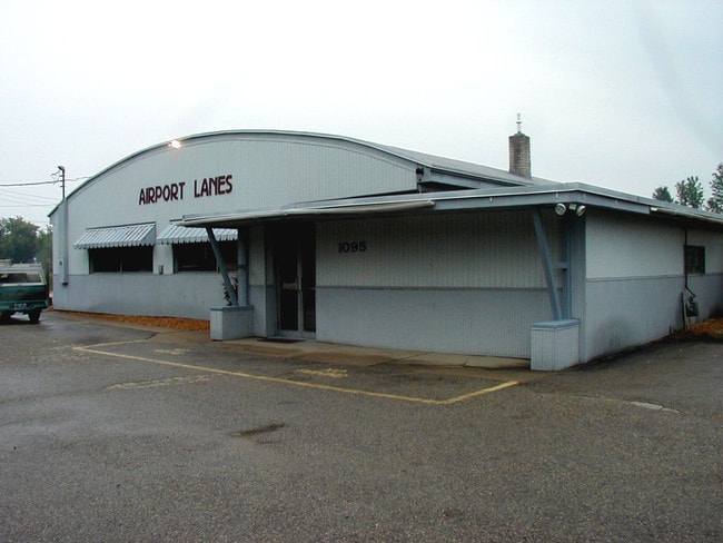
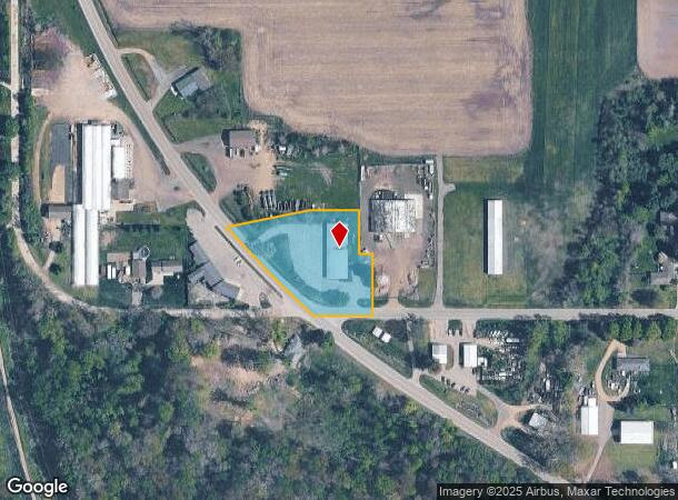
Property Record
1095 137Th Ave, Wayland, MI 49348
NEARBY LISTINGS FOR SALE OR LEASE
Property Detail
1095 137Th Ave
13-031-057-00
COM AT A PT 404' W OF SE COR SW 1/4 NE 1/4 TH N 160.5' TH W 35' TH N 115.5' TH W 130' TH S 77 DEG 50' W 213.51' TO C/L OF OLD US 131 TH SE'LY ON SD C/L TO INTERSEC WITH C/L 137TH AVE TH E TO POB SEC 31 T4N R11W SKETCH: 1.59 AC (91)
Bowlingalley
Allegan
X
Michigan
26005C0260G
1.62 AC
2024
Outlying Allegan County
2025
West Michigan
030402
Holland, MI
7,750 SF
DEMOGRAPHICS near 1095 137Th Ave
1 Mile
3 Mile
5 Mile
2024 Total Population
2,512
7,331
16,168
2029 Population
2,535
7,404
16,237
Pop Growth 2024-2029
+ 0.92%
+ 1.00%
+ 0.43%
Average Age
38
38
38
2024 Total Households
986
2,706
5,710
HH Growth 2024-2029
+ 0.91%
+ 0.96%
+ 0.39%
Median Household Inc
$63,024
$69,444
$76,558
Avg Household Size
2.50
2.60
2.80
2024 Avg HH Vehicles
2.00
2.00
2.00
Median Home Value
$147,607
$181,900
$220,425
Median Year Built
1984
1986
1986
Nearby Places
Map Layers
Map Styles
 Street
 Aerial
- Restaurants
- Banks
- Shops
- Fitness
- Groceries
PUBLIC TRANSPORTATION
AIRPORT
Gerald R Ford International
DRIVE
WALK
Distance
Gerald R Ford International
33 min
22.0 mi
Kalamazoo/Battle Creek International
DRIVE
WALK
Distance
Kalamazoo/Battle Creek International
51 min
38.7 mi
Nearby Properties
Address
Land Use
TOTAL SIZE
Lot Size
Zoning
Address
Land Use
TOTAL SIZE
Lot Size
Zoning
119.76 AC
Address
Land Use
TOTAL SIZE
Lot Size
Zoning
99,487 SF
14.18 AC
Address
Land Use
TOTAL SIZE
Lot Size
Zoning
64,863 SF
10.14 AC
Address
Land Use
TOTAL SIZE
Lot Size
Zoning
69,034 SF
22.50 AC
Address
Land Use
TOTAL SIZE
Lot Size
Zoning
62,500 SF
18.89 AC
Address
Land Use
TOTAL SIZE
Lot Size
Zoning
81,396 SF
12.32 AC
Address
Land Use
TOTAL SIZE
Lot Size
Zoning
60.53 AC
Address
Land Use
TOTAL SIZE
Lot Size
Zoning
70,748 SF
20.74 AC
Address
Land Use
TOTAL SIZE
Lot Size
Zoning
170,318 SF
7.11 AC
Address
Land Use
TOTAL SIZE
Lot Size
Zoning
121,440 SF
8.89 AC
Address
Land Use
TOTAL SIZE
Lot Size
Zoning
46,060 SF
11.88 AC
Address
Land Use
TOTAL SIZE
Lot Size
Zoning
37,449 SF
7.38 AC
Address
Land Use
TOTAL SIZE
Lot Size
Zoning
17,903 SF
2.05 AC
Address
Land Use
TOTAL SIZE
Lot Size
Zoning
197.92 AC
Address
Land Use
TOTAL SIZE
Lot Size
Zoning
12,000 SF
6.47 AC
Address
Land Use
TOTAL SIZE
Lot Size
Zoning
7,200 SF
77.64 AC
I INDUS
Address
Land Use
TOTAL SIZE
Lot Size
Zoning
7,104 SF
2.03 AC
Address
Land Use
TOTAL SIZE
Lot Size
Zoning
33,164 SF
6.88 AC
Address
Land Use
TOTAL SIZE
Lot Size
Zoning
12,320 SF
4.96 AC
Address
Land Use
TOTAL SIZE
Lot Size
Zoning
1,680 SF
240.77 AC
Address
Land Use
TOTAL SIZE
Lot Size
Zoning
7,948 SF
4.91 AC
Address
Land Use
TOTAL SIZE
Lot Size
Zoning
30,600 SF
Address
Land Use
TOTAL SIZE
Lot Size
Zoning
71,798 SF
11.11 AC
Address
Land Use
TOTAL SIZE
Lot Size
Zoning
60.34 AC
Address
Land Use
TOTAL SIZE
Lot Size
Zoning
9,584 SF
2.47 AC
Address
Land Use
TOTAL SIZE
Lot Size
Zoning
20,231 SF
4.27 AC
Address
Land Use
TOTAL SIZE
Lot Size
Zoning
120 AC
Address
Land Use
TOTAL SIZE
Lot Size
Zoning
48.34 AC
Address
Land Use
TOTAL SIZE
Lot Size
Zoning
19,800 SF
40.83 AC
Address
Land Use
TOTAL SIZE
Lot Size
Zoning
2,076 SF
157 AC
AG
The World's #1 Commercial Real Estate Marketplace
Connect with us
© 2026 CoStar Group
The information above has been obtained from sources believed reliable. While we do not doubt its accuracy we have not verified it and make no guarantee, warranty or representation about it. It is your responsibility to independently confirm its accuracy and completeness. Any projections, opinions, assumptions, or estimates used are for example only and do not represent the current or future performance of the property. The value of this transaction to you depends on tax and other factors which should be evaluated by your tax, financial, and legal advisors. You and your advisors should conduct a careful, independent investigation of the property to determine to your satisfaction the suitability of the property for your needs.