Property Record
1095 N Harrah Rd, Harrah, OK 73045


Save to a Folder
{{folder.Name}}
{{folder.ListingIds.length}} Properties
{{folder.ListingIds.length}} Property
Create a New Folder
Property Detail
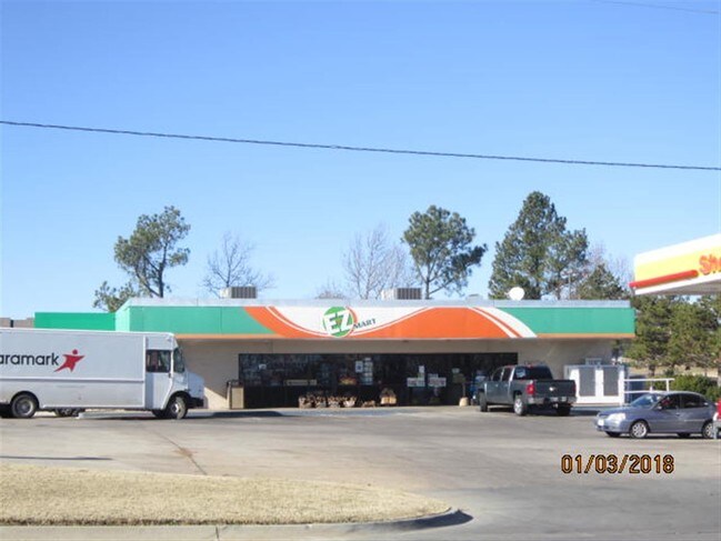
1095 N Harrah Rd
192592070
UNPLTD PT SEC 35 12N 1E 000 000 PT NE4 SEC 35 12N 1E BEG 100FT S & 69.81FT W OF NE/C NE4 TH SELY 21.50FT S149.55FT W166.53FT N170FT E150FT TO BEG CONT .63ACRS MORE OR LESS SUBJ TO EASEMENTS OF RECORD
Storebuilding
OKLAHOMA
B and X Area of moderate flood hazard, usually the area between the limits of the 100-year and 500-year floods.
Oklahoma
2024
0.63 AC
2025
East Oklahoma County
109003
Oklahoma City
2,680 SF
Oklahoma City, OK
NEARBY LISTINGS FOR SALE OR LEASE
DEMOGRAPHICS near 1095 N Harrah Rd
1 mile
3 mile
5 mile
2025 Total Population
2,195
7,567
20,253
2030 Population
2,274
7,822
20,778
Pop Growth 2025-2030
+ 3.60%
+ 3.37%
+ 2.59%
Average Age
40
40
41
2025 Total Households
878
2,835
7,207
HH Growth 2025-2030
+ 3.76%
+ 3.63%
+ 2.86%
Median Household Inc
$66,233
$78,575
$86,161
Avg Household Size
2.40
2.50
2.60
2025 Avg HH Vehicles
2.00
2.00
2.00
Median Home Value
$245,180
$260,410
$274,040
Median Year Built
1982
1990
1989
Nearby Places
Map Layers
Map Styles
 Street
 Aerial
Layers
 Traffic
 Biking
Places
Listings with unknown addresses are not visible on the map
- Restaurants
- Banks
- Shops
- Fitness
- Groceries
PUBLIC TRANSPORTATION
AIRPORT
Will Rogers World
Drive
Walk
Distance
Will Rogers World
48 min
36.2 mi
Nearby Properties
Address
Land Use
TOTAL SIZE
Lot Size
Zoning
Address
Land Use
TOTAL SIZE
Lot Size
Zoning
28,054 SF
2.01 AC
Address
Land Use
TOTAL SIZE
Lot Size
Zoning
52,620 SF
2.48 AC
Address
Land Use
TOTAL SIZE
Lot Size
Zoning
99,544 SF
7.91 AC
Address
Land Use
TOTAL SIZE
Lot Size
Zoning
37,136 SF
6.76 AC
Address
Land Use
TOTAL SIZE
Lot Size
Zoning
1,012 SF
5 AC
Address
Land Use
TOTAL SIZE
Lot Size
Zoning
42,340 SF
8.07 AC
Address
Land Use
TOTAL SIZE
Lot Size
Zoning
6,946 SF
42.63 AC
Address
Land Use
TOTAL SIZE
Lot Size
Zoning
15,180 SF
1.84 AC
Address
Land Use
TOTAL SIZE
Lot Size
Zoning
21,660 SF
2.70 AC
Address
Land Use
TOTAL SIZE
Lot Size
Zoning
77,668 SF
4.98 AC
Address
Land Use
TOTAL SIZE
Lot Size
Zoning
21,348 SF
1.34 AC
Address
Land Use
TOTAL SIZE
Lot Size
Zoning
31,640 SF
5.19 AC
Address
Land Use
TOTAL SIZE
Lot Size
Zoning
21,918 SF
3.19 AC
Address
Land Use
TOTAL SIZE
Lot Size
Zoning
9,000 SF
0.64 AC
Address
Land Use
TOTAL SIZE
Lot Size
Zoning
15,624 SF
1.59 AC
Address
Land Use
TOTAL SIZE
Lot Size
Zoning
1,344 SF
0.14 AC
Address
Land Use
TOTAL SIZE
Lot Size
Zoning
15,880 SF
31 AC
Address
Land Use
TOTAL SIZE
Lot Size
Zoning
19,083 SF
6.03 AC
Address
Land Use
TOTAL SIZE
Lot Size
Zoning
28,212 SF
7.61 AC
Address
Land Use
TOTAL SIZE
Lot Size
Zoning
1,794 SF
9.26 AC
Address
Land Use
TOTAL SIZE
Lot Size
Zoning
32,200 SF
13.45 AC
Address
Land Use
TOTAL SIZE
Lot Size
Zoning
19,286 SF
2.27 AC
Address
Land Use
TOTAL SIZE
Lot Size
Zoning
12,000 SF
10.02 AC
Address
Land Use
TOTAL SIZE
Lot Size
Zoning
14,080 SF
31.57 AC
Address
Land Use
TOTAL SIZE
Lot Size
Zoning
7,560 SF
0.65 AC
Address
Land Use
TOTAL SIZE
Lot Size
Zoning
1,898 SF
0.47 AC
Address
Land Use
TOTAL SIZE
Lot Size
Zoning
24,240 SF
3.36 AC
Address
Land Use
TOTAL SIZE
Lot Size
Zoning
9,220 SF
9.99 AC
Address
Land Use
TOTAL SIZE
Lot Size
Zoning
9,140 SF
0.96 AC
Address
Land Use
TOTAL SIZE
Lot Size
Zoning
5,870 SF
2.12 AC
The World's #1 Commercial Real Estate Marketplace
Connect with us
© 2026 CoStar Group
The information above has been obtained from sources believed reliable. While we do not doubt its accuracy we have not verified it and make no guarantee, warranty or representation about it. It is your responsibility to independently confirm its accuracy and completeness. Any projections, opinions, assumptions, or estimates used are for example only and do not represent the current or future performance of the property. The value of this transaction to you depends on tax and other factors which should be evaluated by your tax, financial, and legal advisors. You and your advisors should conduct a careful, independent investigation of the property to determine to your satisfaction the suitability of the property for your needs.