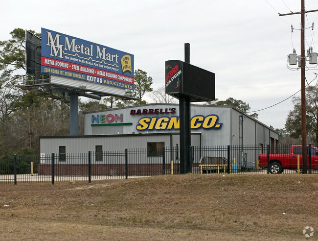
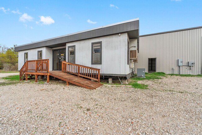
Property Record
10965 Highway 242, Conroe, TX 77385

Save to a Folder
{{folder.Name}}
{{folder.ListingIds.length}} Properties
{{folder.ListingIds.length}} Property
Create a New Folder
Property Detail
10965 Highway 242
0597-00-02126
A0597 - WILBURN MATILDA, TRACT 16 (2.486 AC), TRACT 21 LOT 5-A (0.751 AC), ACRES 3.237
Commercialnec
Montgomery
6
Texas
AE The base floodplain where base flood elevations are provided. AE Zones are now used on new format FIRMs instead of A1-A30 Zones.
5-a
2024
3.24 AC
2025
Montgomery County
692101
Houston
7,914 SF
Houston-Pasadena-The Woodlands, TX
NEARBY LISTINGS FOR SALE OR LEASE
DEMOGRAPHICS near 10965 Highway 242
1 mile
3 mile
5 mile
2025 Total Population
5,828
26,194
90,430
2030 Population
6,816
30,787
106,227
Pop Growth 2025-2030
+ 16.95%
+ 17.53%
+ 17.47%
Average Age
33
36
39
2025 Total Households
1,807
8,935
33,844
HH Growth 2025-2030
+ 17.65%
+ 18.23%
+ 18.06%
Median Household Inc
$114,370
$104,279
$104,004
Avg Household Size
3.20
2.90
2.60
2025 Avg HH Vehicles
2.00
2.00
2.00
Median Home Value
$316,696
$334,262
$365,474
Median Year Built
2010
2010
2008
Nearby Places
Map Layers
Map Styles
 Street
 Aerial
Layers
 Traffic
 Biking
Places
Listings with unknown addresses are not visible on the map
- Restaurants
- Banks
- Shops
- Fitness
- Groceries
PUBLIC TRANSPORTATION
AIRPORT
George Bush Intcntl/Houston
Drive
Walk
Distance
George Bush Intcntl/Houston
33 min
26.4 mi
Freight Ports
Port of Houston
Drive
Walk
Distance
Port of Houston
56 min
42.1 mi
SALE & LEASE HISTORY
LISTING DATE
SALE/LEASE

Dec 07, 2021
For Lease
Nearby Properties
Address
Land Use
TOTAL SIZE
Lot Size
Zoning
Address
Land Use
TOTAL SIZE
Lot Size
Zoning
743,246 SF
40.65 AC
Address
Land Use
TOTAL SIZE
Lot Size
Zoning
465,986 SF
21.55 AC
Address
Land Use
TOTAL SIZE
Lot Size
Zoning
813,318 SF
20.95 AC
Address
Land Use
TOTAL SIZE
Lot Size
Zoning
370,039 SF
40.66 AC
Address
Land Use
TOTAL SIZE
Lot Size
Zoning
579,596 SF
1.32 AC
Address
Land Use
TOTAL SIZE
Lot Size
Zoning
344,233 SF
15.24 AC
Address
Land Use
TOTAL SIZE
Lot Size
Zoning
221,955 SF
7.71 AC
Address
Land Use
TOTAL SIZE
Lot Size
Zoning
217,654 SF
9.81 AC
Address
Land Use
TOTAL SIZE
Lot Size
Zoning
158,093 SF
13.88 AC
Address
Land Use
TOTAL SIZE
Lot Size
Zoning
181,860 SF
22.85 AC
6
Address
Land Use
TOTAL SIZE
Lot Size
Zoning
311,767 SF
32 AC
Address
Land Use
TOTAL SIZE
Lot Size
Zoning
371,718 SF
3.43 AC
Address
Land Use
TOTAL SIZE
Lot Size
Zoning
54,470 SF
9.02 AC
Address
Land Use
TOTAL SIZE
Lot Size
Zoning
56,150 SF
8.92 AC
6
Address
Land Use
TOTAL SIZE
Lot Size
Zoning
350,349 SF
15.85 AC
6
Address
Land Use
TOTAL SIZE
Lot Size
Zoning
99,700 SF
1.30 AC
Address
Land Use
TOTAL SIZE
Lot Size
Zoning
111,588 SF
3.41 AC
Address
Land Use
TOTAL SIZE
Lot Size
Zoning
316,829 SF
25.90 AC
6
Address
Land Use
TOTAL SIZE
Lot Size
Zoning
78,874 SF
5.97 AC
Address
Land Use
TOTAL SIZE
Lot Size
Zoning
58,000 SF
60 AC
Address
Land Use
TOTAL SIZE
Lot Size
Zoning
152,036 SF
17.46 AC
Address
Land Use
TOTAL SIZE
Lot Size
Zoning
206,872 SF
21.25 AC
Address
Land Use
TOTAL SIZE
Lot Size
Zoning
110,832 SF
10.73 AC
Address
Land Use
TOTAL SIZE
Lot Size
Zoning
79,664 SF
2.65 AC
Address
Land Use
TOTAL SIZE
Lot Size
Zoning
51,387 SF
4.09 AC
Address
Land Use
TOTAL SIZE
Lot Size
Zoning
154,675 SF
17.12 AC
Address
Land Use
TOTAL SIZE
Lot Size
Zoning
70,400 SF
9.19 AC
Address
Land Use
TOTAL SIZE
Lot Size
Zoning
64,651 SF
4.38 AC
Address
Land Use
TOTAL SIZE
Lot Size
Zoning
77,930 SF
0.85 AC
Address
Land Use
TOTAL SIZE
Lot Size
Zoning
80,991 SF
3.67 AC
The World's #1 Commercial Real Estate Marketplace
Connect with us
© 2026 CoStar Group
The information above has been obtained from sources believed reliable. While we do not doubt its accuracy we have not verified it and make no guarantee, warranty or representation about it. It is your responsibility to independently confirm its accuracy and completeness. Any projections, opinions, assumptions, or estimates used are for example only and do not represent the current or future performance of the property. The value of this transaction to you depends on tax and other factors which should be evaluated by your tax, financial, and legal advisors. You and your advisors should conduct a careful, independent investigation of the property to determine to your satisfaction the suitability of the property for your needs.