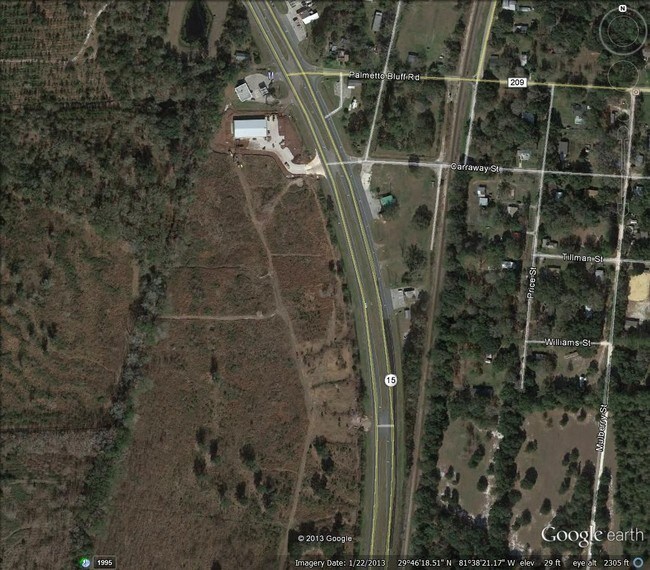
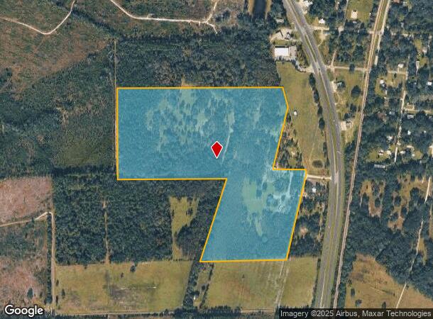
Property Record
1069 N Highway 17, Palatka, FL 32177
NEARBY LISTINGS FOR SALE OR LEASE
-
-
View all Palatka listings for sale on LoopNet.com
Property Detail
1069 N Highway 17
Other Market Areas
Town Of Bostwick
Palatka, FL
Putnam
30-08-27-0000-0150-0000
Florida
Sfr
43.64 AC
A
Florida Central North Area
12019C0425E
DEMOGRAPHICS near 1069 N Highway 17
1 Mile
3 Mile
5 Mile
2024 Total Population
383
827
3,494
2029 Population
406
878
3,716
Pop Growth 2024-2029
+ 6.01%
+ 6.17%
+ 6.35%
Average Age
45
45
46
2024 Total Households
155
335
1,450
HH Growth 2024-2029
+ 6.45%
+ 5.97%
+ 6.41%
Median Household Inc
$56,666
$56,666
$61,565
Avg Household Size
2.40
2.40
2.40
2024 Avg HH Vehicles
2.00
2.00
2.00
Median Home Value
$180,850
$175,229
$199,343
Median Year Built
1993
1992
1993
Nearby Places
Map Layers
Map Styles
 Street
 Aerial
- Restaurants
- Banks
- Shops
- Fitness
- Groceries
PUBLIC TRANSPORTATION
COMMUTER RAIL
Palatka Amtrak (Silver Meteor - Amtrak, Silver Star - Amtrak)
DRIVE
WALK
Distance
Palatka Amtrak (Silver Meteor - Amtrak, Silver Star - Amtrak)
14 min
9.6 mi
Freight Ports
Jacksonville Port
DRIVE
WALK
Distance
Jacksonville Port
73 min
47.6 mi
SALE & LEASE HISTORY
LISTING DATE
SALE/LEASE

Sep 24, 2016
For Sale
May 30, 2018
For Sale
Mar 27, 2017
For Sale
Nearby Properties
Address
Land Use
TOTAL SIZE
Lot Size
Zoning
Address
Land Use
TOTAL SIZE
Lot Size
Zoning
22,360 SF
103.82 AC
Address
Land Use
TOTAL SIZE
Lot Size
Zoning
21,608 SF
1,990.73 AC
Address
Land Use
TOTAL SIZE
Lot Size
Zoning
1,872 SF
5.50 AC
Address
Land Use
TOTAL SIZE
Lot Size
Zoning
9,070 SF
1.93 AC
Address
Land Use
TOTAL SIZE
Lot Size
Zoning
118.46 AC
Address
Land Use
TOTAL SIZE
Lot Size
Zoning
315.11 AC
Address
Land Use
TOTAL SIZE
Lot Size
Zoning
2,018 SF
0.87 AC
Address
Land Use
TOTAL SIZE
Lot Size
Zoning
4,616 SF
2.68 AC
Address
Land Use
TOTAL SIZE
Lot Size
Zoning
924 SF
348.26 AC
Address
Land Use
TOTAL SIZE
Lot Size
Zoning
9,000 SF
9.73 AC
Address
Land Use
TOTAL SIZE
Lot Size
Zoning
2,060 SF
4.44 AC
Address
Land Use
TOTAL SIZE
Lot Size
Zoning
42.44 AC
Address
Land Use
TOTAL SIZE
Lot Size
Zoning
1,344 SF
3.50 AC
Address
Land Use
TOTAL SIZE
Lot Size
Zoning
64.69 AC
Address
Land Use
TOTAL SIZE
Lot Size
Zoning
1,800 SF
1.19 AC
Address
Land Use
TOTAL SIZE
Lot Size
Zoning
3.95 AC
Address
Land Use
TOTAL SIZE
Lot Size
Zoning
2,112 SF
0.93 AC
Address
Land Use
TOTAL SIZE
Lot Size
Zoning
7,560 SF
2.07 AC
Address
Land Use
TOTAL SIZE
Lot Size
Zoning
1,446 SF
1.24 AC
Address
Land Use
TOTAL SIZE
Lot Size
Zoning
27.33 AC
Address
Land Use
TOTAL SIZE
Lot Size
Zoning
6.97 AC
Address
Land Use
TOTAL SIZE
Lot Size
Zoning
3,760 SF
6.39 AC
Address
Land Use
TOTAL SIZE
Lot Size
Zoning
4.95 AC
Address
Land Use
TOTAL SIZE
Lot Size
Zoning
837 SF
1.12 AC
Address
Land Use
TOTAL SIZE
Lot Size
Zoning
85.70 AC
Address
Land Use
TOTAL SIZE
Lot Size
Zoning
639.44 AC
Address
Land Use
TOTAL SIZE
Lot Size
Zoning
Address
Land Use
TOTAL SIZE
Lot Size
Zoning
159.02 AC
Address
Land Use
TOTAL SIZE
Lot Size
Zoning
9.19 AC
Address
Land Use
TOTAL SIZE
Lot Size
Zoning
1,120 SF
1.23 AC
The World's #1 Commercial Real Estate Marketplace
Connect with us
© 2025 CoStar Group
The information above has been obtained from sources believed reliable. While we do not doubt its accuracy we have not verified it and make no guarantee, warranty or representation about it. It is your responsibility to independently confirm its accuracy and completeness. Any projections, opinions, assumptions, or estimates used are for example only and do not represent the current or future performance of the property. The value of this transaction to you depends on tax and other factors which should be evaluated by your tax, financial, and legal advisors. You and your advisors should conduct a careful, independent investigation of the property to determine to your satisfaction the suitability of the property for your needs.