Property Record
10975 Tollhouse Rd, Clovis, CA 93619

Property Detail
10975 Tollhouse Rd
Fresno, CA
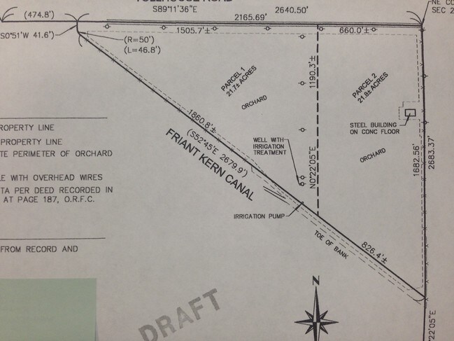
40.55 AC NELY OF CANAL IN NE1/4 SEC 29 T12R22
150-102-32
FRESNO
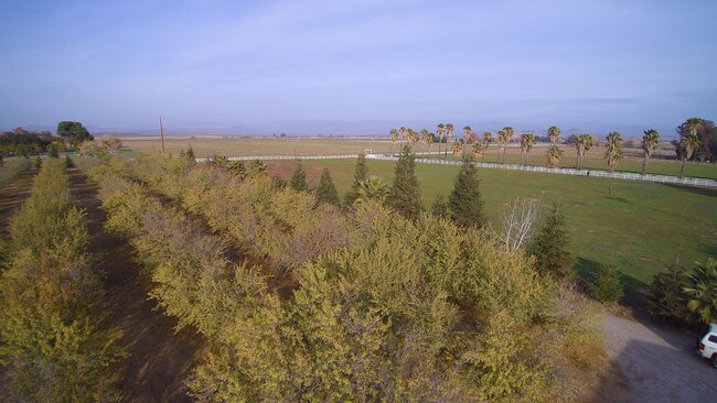
Orchard
California
AE40
39.10 AC
2025
E Outlying Fresno County
2025
Fresno
005518
NEARBY LISTINGS FOR SALE OR LEASE
-
-
View all Clovis listings for sale on LoopNet.com
DEMOGRAPHICS near 10975 Tollhouse Rd
1 mile
3 mile
5 mile
2025 Total Population
25
4,731
31,661
2030 Population
25
4,777
32,243
Pop Growth 2025-2030
0.00%
+ 0.97%
+ 1.84%
Average Age
44
40
38
2025 Total Households
9
1,642
10,361
HH Growth 2025-2030
0.00%
+ 0.97%
+ 1.85%
Median Household Inc
$149,999
$117,574
$135,189
Avg Household Size
2.50
2.80
3.00
2025 Avg HH Vehicles
3.00
2.00
2.00
Median Home Value
$687,500
$574,269
$643,491
Median Year Built
1989
2004
2007
Nearby Places
Map Layers
Map Styles
 Street
 Aerial
Transit
 Traffic
 Biking
Places
Listings with unknown addresses are not visible on the map
- Restaurants
- Banks
- Shops
- Fitness
- Groceries
PUBLIC TRANSPORTATION
AIRPORT
Fresno Yosemite International
Drive
Walk
Distance
Fresno Yosemite International
20 min
14.3 mi
Freight Ports
Port of Stockton
Drive
Walk
Distance
Port of Stockton
166 min
136.4 mi
Nearby Properties
Address
Land Use
TOTAL SIZE
Lot Size
Zoning
Address
Land Use
TOTAL SIZE
Lot Size
Zoning
155 AC
AL20
Address
Land Use
TOTAL SIZE
Lot Size
Zoning
3,489 SF
40.47 AC
AL40
Address
Land Use
TOTAL SIZE
Lot Size
Zoning
78.36 AC
Address
Land Use
TOTAL SIZE
Lot Size
Zoning
3,164 SF
36.73 AC
AE40
Address
Land Use
TOTAL SIZE
Lot Size
Zoning
2,010 SF
65.41 AC
AE40
Address
Land Use
TOTAL SIZE
Lot Size
Zoning
210.80 AC
Address
Land Use
TOTAL SIZE
Lot Size
Zoning
2,500 SF
18.87 AC
AL40
Address
Land Use
TOTAL SIZE
Lot Size
Zoning
5,801 SF
20 AC
AE20
Address
Land Use
TOTAL SIZE
Lot Size
Zoning
3,441 SF
19.90 AC
AL40
Address
Land Use
TOTAL SIZE
Lot Size
Zoning
200 AC
AE40
Address
Land Use
TOTAL SIZE
Lot Size
Zoning
2,626 SF
21.16 AC
AE20
Address
Land Use
TOTAL SIZE
Lot Size
Zoning
6,955 SF
18.40 AC
AL40
Address
Land Use
TOTAL SIZE
Lot Size
Zoning
2,652 SF
20 AC
AL40
Address
Land Use
TOTAL SIZE
Lot Size
Zoning
4,113 SF
20 AC
AE20
Address
Land Use
TOTAL SIZE
Lot Size
Zoning
4,268 SF
17.78 AC
AL40
Address
Land Use
TOTAL SIZE
Lot Size
Zoning
2,531 SF
43.94 AC
AE40
Address
Land Use
TOTAL SIZE
Lot Size
Zoning
1,844 SF
0.20 AC
AE20
Address
Land Use
TOTAL SIZE
Lot Size
Zoning
40.40 AC
AL40
Address
Land Use
TOTAL SIZE
Lot Size
Zoning
20.32 AC
AL40
Address
Land Use
TOTAL SIZE
Lot Size
Zoning
1,646 SF
485.82 AC
A1
Address
Land Use
TOTAL SIZE
Lot Size
Zoning
20.56 AC
AL40
Address
Land Use
TOTAL SIZE
Lot Size
Zoning
9.47 AC
AL20
Address
Land Use
TOTAL SIZE
Lot Size
Zoning
3,588 SF
120 AC
AE40
Address
Land Use
TOTAL SIZE
Lot Size
Zoning
4,038 SF
18.88 AC
AL40
Address
Land Use
TOTAL SIZE
Lot Size
Zoning
2,063 SF
20.24 AC
AL40
Address
Land Use
TOTAL SIZE
Lot Size
Zoning
3,190 SF
20.02 AC
AE20
The World's #1 Commercial Real Estate Marketplace
Connect with us
© 2026 CoStar Group
The information above has been obtained from sources believed reliable. While we do not doubt its accuracy we have not verified it and make no guarantee, warranty or representation about it. It is your responsibility to independently confirm its accuracy and completeness. Any projections, opinions, assumptions, or estimates used are for example only and do not represent the current or future performance of the property. The value of this transaction to you depends on tax and other factors which should be evaluated by your tax, financial, and legal advisors. You and your advisors should conduct a careful, independent investigation of the property to determine to your satisfaction the suitability of the property for your needs.