Property Record
10982 Clark Rd, Inver Grove Heights, MN 55077
NEARBY LISTINGS FOR SALE OR LEASE
-
-
View all Inver Grove Heights listings for sale on LoopNet.com
Property Detail
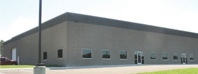
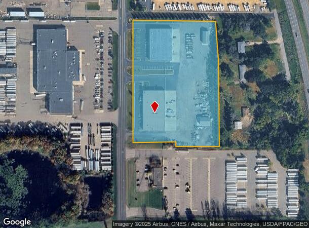
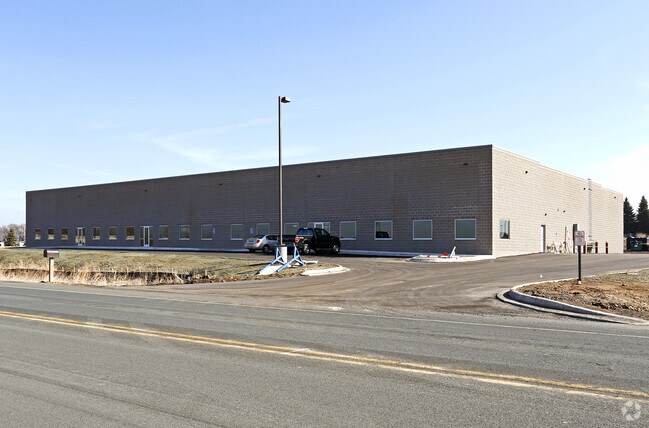
10982 Clark Rd
Minneapolis-St. Paul-Bloomington, MN-WI
Gainey Addition
20-28400-01-012
1 1 PT OF LOT 1 BLK 1 LYING N'LY OF LINE COM NW COR S ON W LINE 668.57 FT TO BEG OF LINE N 89D09M09S E 236.46 T S 0D50M51S E 27.11 FT TO W'LY EXT OF A N L INESAID LOT 1 N 89D09M 09S E ON SAID W'LY EXT OF SAID N LINE 239.50 FT TO ANGLE POINT IN E LINE
Industrialgeneral
Dakota
X
Minnesota
27037C0120E
1
2024
7.31 AC
2024
South Central
060508
Minneapolis/St Paul
47,976 SF
DEMOGRAPHICS near 10982 Clark Rd
1 Mile
3 Mile
5 Mile
2024 Total Population
140
7,787
63,602
2029 Population
142
7,922
66,025
Pop Growth 2024-2029
+ 1.43%
+ 1.73%
+ 3.81%
Average Age
43
43
40
2024 Total Households
46
3,134
22,981
HH Growth 2024-2029
+ 2.17%
+ 1.60%
+ 3.72%
Median Household Inc
$154,167
$117,036
$112,700
Avg Household Size
2.80
2.50
2.70
2024 Avg HH Vehicles
3.00
2.00
2.00
Median Home Value
$466,666
$408,333
$355,959
Median Year Built
1986
1995
1992
Nearby Places
Map Layers
Map Styles
 Street
 Aerial
- Restaurants
- Banks
- Shops
- Fitness
- Groceries
PUBLIC TRANSPORTATION
AIRPORT
Minneapolis-St Paul International/Wold-Chamberlain
DRIVE
WALK
Distance
Minneapolis-St Paul International/Wold-Chamberlain
24 min
16.0 mi
Freight Ports
Port Milwaukee
DRIVE
WALK
Distance
Port Milwaukee
374 min
338.3 mi
Nearby Properties
Address
Land Use
TOTAL SIZE
Lot Size
Zoning
Address
Land Use
TOTAL SIZE
Lot Size
Zoning
595.66 AC
Address
Land Use
TOTAL SIZE
Lot Size
Zoning
Address
Land Use
TOTAL SIZE
Lot Size
Zoning
6,566 SF
48.32 AC
Address
Land Use
TOTAL SIZE
Lot Size
Zoning
212,331 SF
9.27 AC
Address
Land Use
TOTAL SIZE
Lot Size
Zoning
600 SF
348.83 AC
Address
Land Use
TOTAL SIZE
Lot Size
Zoning
114,778 SF
27.86 AC
Address
Land Use
TOTAL SIZE
Lot Size
Zoning
97,792 SF
16.39 AC
Address
Land Use
TOTAL SIZE
Lot Size
Zoning
72,350 SF
1.86 AC
Address
Land Use
TOTAL SIZE
Lot Size
Zoning
76,452 SF
13.76 AC
Address
Land Use
TOTAL SIZE
Lot Size
Zoning
141,090 SF
16.79 AC
Address
Land Use
TOTAL SIZE
Lot Size
Zoning
71,296 SF
4.99 AC
Address
Land Use
TOTAL SIZE
Lot Size
Zoning
86,363 SF
22.51 AC
Address
Land Use
TOTAL SIZE
Lot Size
Zoning
479,206 SF
24.35 AC
Address
Land Use
TOTAL SIZE
Lot Size
Zoning
434.99 AC
Address
Land Use
TOTAL SIZE
Lot Size
Zoning
178,943 SF
15.45 AC
Address
Land Use
TOTAL SIZE
Lot Size
Zoning
Address
Land Use
TOTAL SIZE
Lot Size
Zoning
46,128 SF
25.93 AC
Address
Land Use
TOTAL SIZE
Lot Size
Zoning
25,618 SF
1.84 AC
Address
Land Use
TOTAL SIZE
Lot Size
Zoning
4,400 SF
33.14 AC
Address
Land Use
TOTAL SIZE
Lot Size
Zoning
470.06 AC
Address
Land Use
TOTAL SIZE
Lot Size
Zoning
253,896 SF
121.68 AC
Address
Land Use
TOTAL SIZE
Lot Size
Zoning
56,684 SF
5.77 AC
Address
Land Use
TOTAL SIZE
Lot Size
Zoning
1,056 SF
189.82 AC
Address
Land Use
TOTAL SIZE
Lot Size
Zoning
159,414 SF
25.25 AC
Address
Land Use
TOTAL SIZE
Lot Size
Zoning
40,160 SF
6.45 AC
Address
Land Use
TOTAL SIZE
Lot Size
Zoning
33,002 SF
1.89 AC
Address
Land Use
TOTAL SIZE
Lot Size
Zoning
46,186 SF
7.34 AC
Address
Land Use
TOTAL SIZE
Lot Size
Zoning
56,594 SF
34.09 AC
The World's #1 Commercial Real Estate Marketplace
Connect with us
© 2026 CoStar Group
The information above has been obtained from sources believed reliable. While we do not doubt its accuracy we have not verified it and make no guarantee, warranty or representation about it. It is your responsibility to independently confirm its accuracy and completeness. Any projections, opinions, assumptions, or estimates used are for example only and do not represent the current or future performance of the property. The value of this transaction to you depends on tax and other factors which should be evaluated by your tax, financial, and legal advisors. You and your advisors should conduct a careful, independent investigation of the property to determine to your satisfaction the suitability of the property for your needs.