Property Record
10982 Cumberland Dr, Papillion, NE 68046

NEARBY LISTINGS FOR SALE OR LEASE
-
-
View all Papillion listings for sale on LoopNet.com
Property Detail
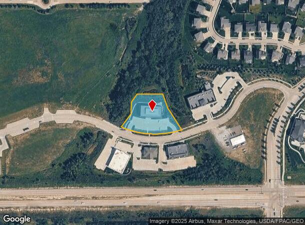
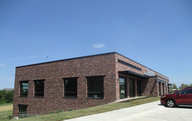
10982 Cumberland Dr
Omaha, NE-IA
Granite Falls Commercial
011598143
LOT 15 GRANITE FALLS COMMERCIAL (1.303 AC)
Commercialnec
Sarpy
X
Nebraska
31153C0064H
15
2024
1.30 AC
2025
South Central
010623
Omaha/Council Bluffs
7,936 SF
DEMOGRAPHICS near 10982 Cumberland Dr
1 Mile
3 Mile
5 Mile
2024 Total Population
3,013
39,455
123,812
2029 Population
3,267
42,485
130,525
Pop Growth 2024-2029
+ 8.43%
+ 7.68%
+ 5.42%
Average Age
35
38
38
2024 Total Households
1,086
14,802
48,926
HH Growth 2024-2029
+ 8.75%
+ 7.94%
+ 5.38%
Median Household Inc
$102,323
$93,040
$77,835
Avg Household Size
2.80
2.60
2.50
2024 Avg HH Vehicles
2.00
2.00
2.00
Median Home Value
$358,372
$288,631
$243,267
Median Year Built
2010
1998
1987
Nearby Places
Map Layers
Map Styles
 Street
 Aerial
- Restaurants
- Banks
- Shops
- Fitness
- Groceries
PUBLIC TRANSPORTATION
AIRPORT
Eppley Airfield
DRIVE
WALK
Distance
Eppley Airfield
33 min
20.3 mi
Freight Ports
Tulsa Port Of Catoosa
DRIVE
WALK
Distance
Tulsa Port Of Catoosa
464 min
417.7 mi
Nearby Properties
Address
Land Use
TOTAL SIZE
Lot Size
Zoning
Address
Land Use
TOTAL SIZE
Lot Size
Zoning
94.11 AC
Address
Land Use
TOTAL SIZE
Lot Size
Zoning
51.65 AC
Address
Land Use
TOTAL SIZE
Lot Size
Zoning
28,401 SF
27.31 AC
Address
Land Use
TOTAL SIZE
Lot Size
Zoning
3,654 SF
39.62 AC
Address
Land Use
TOTAL SIZE
Lot Size
Zoning
543,301 SF
2.30 AC
IL
Address
Land Use
TOTAL SIZE
Lot Size
Zoning
28,820 SF
16.81 AC
Address
Land Use
TOTAL SIZE
Lot Size
Zoning
599,779 SF
46.87 AC
I1
Address
Land Use
TOTAL SIZE
Lot Size
Zoning
252,985 SF
6.53 AC
Address
Land Use
TOTAL SIZE
Lot Size
Zoning
317,277 SF
20.12 AC
Address
Land Use
TOTAL SIZE
Lot Size
Zoning
8.10 AC
Address
Land Use
TOTAL SIZE
Lot Size
Zoning
46,886 SF
19.29 AC
Address
Land Use
TOTAL SIZE
Lot Size
Zoning
23.99 AC
Address
Land Use
TOTAL SIZE
Lot Size
Zoning
22.05 AC
Address
Land Use
TOTAL SIZE
Lot Size
Zoning
85,632 SF
5.69 AC
Address
Land Use
TOTAL SIZE
Lot Size
Zoning
23,890 SF
14.34 AC
I2
Address
Land Use
TOTAL SIZE
Lot Size
Zoning
56,150 SF
28.48 AC
Address
Land Use
TOTAL SIZE
Lot Size
Zoning
240,122 SF
10.16 AC
Address
Land Use
TOTAL SIZE
Lot Size
Zoning
210,585 SF
142.28 AC
I2
Address
Land Use
TOTAL SIZE
Lot Size
Zoning
250,999 SF
17.10 AC
Address
Land Use
TOTAL SIZE
Lot Size
Zoning
258,637 SF
24.30 AC
Address
Land Use
TOTAL SIZE
Lot Size
Zoning
6,210 SF
8.28 AC
Address
Land Use
TOTAL SIZE
Lot Size
Zoning
2,610 SF
9.96 AC
Address
Land Use
TOTAL SIZE
Lot Size
Zoning
1,356 SF
415.31 AC
Address
Land Use
TOTAL SIZE
Lot Size
Zoning
120,500 SF
12.05 AC
IL
Address
Land Use
TOTAL SIZE
Lot Size
Zoning
128,497 SF
13.49 AC
Address
Land Use
TOTAL SIZE
Lot Size
Zoning
12,998 SF
15.63 AC
Address
Land Use
TOTAL SIZE
Lot Size
Zoning
20.66 AC
Address
Land Use
TOTAL SIZE
Lot Size
Zoning
8,649 SF
17.76 AC
Address
Land Use
TOTAL SIZE
Lot Size
Zoning
8,700 SF
12.68 AC
I2
Address
Land Use
TOTAL SIZE
Lot Size
Zoning
115,294 SF
15.26 AC
The World's #1 Commercial Real Estate Marketplace
Connect with us
© 2026 CoStar Group
The information above has been obtained from sources believed reliable. While we do not doubt its accuracy we have not verified it and make no guarantee, warranty or representation about it. It is your responsibility to independently confirm its accuracy and completeness. Any projections, opinions, assumptions, or estimates used are for example only and do not represent the current or future performance of the property. The value of this transaction to you depends on tax and other factors which should be evaluated by your tax, financial, and legal advisors. You and your advisors should conduct a careful, independent investigation of the property to determine to your satisfaction the suitability of the property for your needs.