Property Record
1131 New Ashford Rd, Williamstown, MA 01267
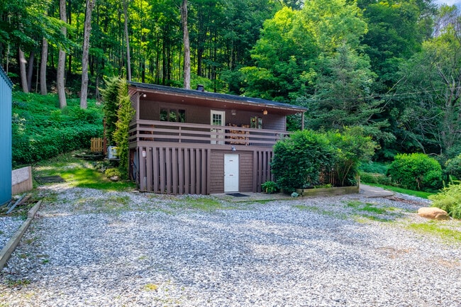
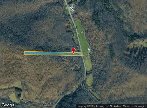
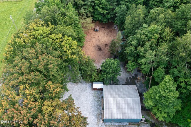
This Property Is For Sale
NEARBY LISTINGS FOR SALE OR LEASE
-
-
View all Williamstown listings for sale on LoopNet.com
Property Detail
1131 New Ashford Rd
Other Market Areas
Berkshire
Pittsfield, MA
Massachusetts
WILL-000215-000000-000017
9.19 AC
Sfr
Massachusetts North/West Area
2,403 SF
DEMOGRAPHICS near 1131 New Ashford Rd
1 Mile
3 Mile
5 Mile
2024 Total Population
72
622
2,852
2029 Population
71
620
2,851
Pop Growth 2024-2029
(1.39%)
(0.32%)
(0.04%)
Average Age
50
50
46
2024 Total Households
31
263
1,110
HH Growth 2024-2029
(3.23%)
(0.38%)
+ 0.09%
Median Household Inc
$87,500
$107,407
$85,227
Avg Household Size
2.20
2.20
2.20
2024 Avg HH Vehicles
2.00
2.00
2.00
Median Home Value
$399,999
$472,727
$409,740
Median Year Built
1965
1965
1964
Nearby Places
Map Layers
Map Styles
 Street
 Aerial
- Restaurants
- Banks
- Shops
- Fitness
- Groceries
PUBLIC TRANSPORTATION
AIRPORT
Albany International
DRIVE
WALK
Distance
Albany International
66 min
40.7 mi
Freight Ports
Albany, NY Port
DRIVE
WALK
Distance
Albany, NY Port
64 min
38.3 mi
Nearby Properties
Address
Land Use
TOTAL SIZE
Lot Size
Zoning
Address
Land Use
TOTAL SIZE
Lot Size
Zoning
205,058 SF
114 AC
RR2
Address
Land Use
TOTAL SIZE
Lot Size
Zoning
23,252 SF
12.90 AC
RR2
Address
Land Use
TOTAL SIZE
Lot Size
Zoning
1,889 AC
Address
Land Use
TOTAL SIZE
Lot Size
Zoning
11,246 SF
68 AC
RR2
Address
Land Use
TOTAL SIZE
Lot Size
Zoning
419 AC
Address
Land Use
TOTAL SIZE
Lot Size
Zoning
Address
Land Use
TOTAL SIZE
Lot Size
Zoning
21,150 SF
382.99 AC
Address
Land Use
TOTAL SIZE
Lot Size
Zoning
141 AC
RR2
Address
Land Use
TOTAL SIZE
Lot Size
Zoning
12,384 SF
512.09 AC
Address
Land Use
TOTAL SIZE
Lot Size
Zoning
134 AC
RR2
Address
Land Use
TOTAL SIZE
Lot Size
Zoning
41,072 SF
4.30 AC
Address
Land Use
TOTAL SIZE
Lot Size
Zoning
Address
Land Use
TOTAL SIZE
Lot Size
Zoning
16.95 AC
RR2
Address
Land Use
TOTAL SIZE
Lot Size
Zoning
13,920 SF
6.33 AC
Address
Land Use
TOTAL SIZE
Lot Size
Zoning
8,298 SF
2.02 AC
Address
Land Use
TOTAL SIZE
Lot Size
Zoning
0.67 AC
RR2
Address
Land Use
TOTAL SIZE
Lot Size
Zoning
4.20 AC
Address
Land Use
TOTAL SIZE
Lot Size
Zoning
3,096 SF
6.80 AC
RR2
Address
Land Use
TOTAL SIZE
Lot Size
Zoning
2,261 SF
2.01 AC
Address
Land Use
TOTAL SIZE
Lot Size
Zoning
4,930 SF
1.20 AC
Address
Land Use
TOTAL SIZE
Lot Size
Zoning
314 AC
AR
Address
Land Use
TOTAL SIZE
Lot Size
Zoning
55 AC
RR2
Address
Land Use
TOTAL SIZE
Lot Size
Zoning
276.83 AC
1
Address
Land Use
TOTAL SIZE
Lot Size
Zoning
1,134 SF
113 AC
RR2
Address
Land Use
TOTAL SIZE
Lot Size
Zoning
16,657 SF
278.26 AC
RR2
Address
Land Use
TOTAL SIZE
Lot Size
Zoning
4,161 SF
5.74 AC
RR2
Address
Land Use
TOTAL SIZE
Lot Size
Zoning
5,104 SF
1.09 AC
RR2
Address
Land Use
TOTAL SIZE
Lot Size
Zoning
15.39 AC
RR2
Address
Land Use
TOTAL SIZE
Lot Size
Zoning
137.20 AC
RR2
Address
Land Use
TOTAL SIZE
Lot Size
Zoning
18.53 AC
RR2
The World's #1 Commercial Real Estate Marketplace
Connect with us
© 2025 CoStar Group
The information above has been obtained from sources believed reliable. While we do not doubt its accuracy we have not verified it and make no guarantee, warranty or representation about it. It is your responsibility to independently confirm its accuracy and completeness. Any projections, opinions, assumptions, or estimates used are for example only and do not represent the current or future performance of the property. The value of this transaction to you depends on tax and other factors which should be evaluated by your tax, financial, and legal advisors. You and your advisors should conduct a careful, independent investigation of the property to determine to your satisfaction the suitability of the property for your needs.