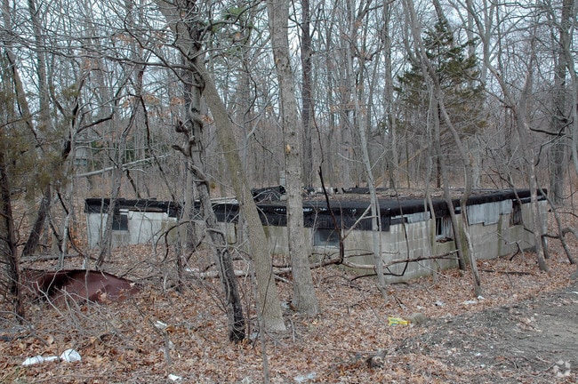
Property Record
1099 Us Highway 9, Howell, NJ 07731

NEARBY LISTINGS FOR SALE OR LEASE
Property Detail
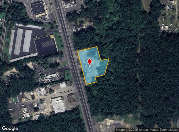
1099 Us Highway 9
21-00144-0000-00117
Monmouth
Commercialnec
New Jersey
X
116.1
34025C0284F
1.62 AC
2024
Western Monmouth
2025
Northern New Jersey
811200
New York-Jersey City-White Plains, NY-NJ
496 SF
DEMOGRAPHICS near 1099 Us Highway 9
1 Mile
3 Mile
5 Mile
2024 Total Population
6,029
28,458
94,870
2029 Population
5,960
28,154
94,680
Pop Growth 2024-2029
(1.14%)
(1.07%)
(0.20%)
Average Age
44
43
41
2024 Total Households
2,544
10,624
33,324
HH Growth 2024-2029
(1.30%)
(1.30%)
(0.59%)
Median Household Inc
$96,102
$104,097
$110,667
Avg Household Size
2.30
2.60
2.70
2024 Avg HH Vehicles
2.00
2.00
2.00
Median Home Value
$410,265
$450,355
$425,957
Median Year Built
1984
1984
1982
Nearby Places
Map Layers
Map Styles
 Street
 Aerial
- Restaurants
- Banks
- Shops
- Fitness
- Groceries
PUBLIC TRANSPORTATION
AIRPORT
Trenton Mercer
DRIVE
WALK
Distance
Trenton Mercer
54 min
39.9 mi
Newark Liberty International
DRIVE
WALK
Distance
Newark Liberty International
55 min
44.7 mi
Freight Ports
New York Container Terminal
DRIVE
WALK
Distance
New York Container Terminal
49 min
36.9 mi
Nearby Properties
Address
Land Use
TOTAL SIZE
Lot Size
Zoning
Address
Land Use
TOTAL SIZE
Lot Size
Zoning
36.48 AC
HD-2
Address
Land Use
TOTAL SIZE
Lot Size
Zoning
15.69 AC
HMUD
Address
Land Use
TOTAL SIZE
Lot Size
Zoning
25.63 AC
HD-1
Address
Land Use
TOTAL SIZE
Lot Size
Zoning
114,738 SF
19.02 AC
M-1
Address
Land Use
TOTAL SIZE
Lot Size
Zoning
182.80 AC
R-E
Address
Land Use
TOTAL SIZE
Lot Size
Zoning
241,399 SF
69.89 AC
R-40
Address
Land Use
TOTAL SIZE
Lot Size
Zoning
144.23 AC
R-E
Address
Land Use
TOTAL SIZE
Lot Size
Zoning
136,800 SF
14.08 AC
ARE1
Address
Land Use
TOTAL SIZE
Lot Size
Zoning
7,112 SF
10.01 AC
CM3A
Address
Land Use
TOTAL SIZE
Lot Size
Zoning
126,388 SF
11.56 AC
CM10
Address
Land Use
TOTAL SIZE
Lot Size
Zoning
2,674 SF
80 AC
R-E
Address
Land Use
TOTAL SIZE
Lot Size
Zoning
81,657 SF
12.62 AC
B-10
Address
Land Use
TOTAL SIZE
Lot Size
Zoning
126,300 SF
10.12 AC
M-1
Address
Land Use
TOTAL SIZE
Lot Size
Zoning
120,000 SF
77 AC
ARE2
Address
Land Use
TOTAL SIZE
Lot Size
Zoning
77.72 AC
R-E
Address
Land Use
TOTAL SIZE
Lot Size
Zoning
8,694 SF
73.93 AC
R-40
Address
Land Use
TOTAL SIZE
Lot Size
Zoning
76.77 AC
R-E
Address
Land Use
TOTAL SIZE
Lot Size
Zoning
73.44 AC
R-E
Address
Land Use
TOTAL SIZE
Lot Size
Zoning
43.22 AC
ARE2
Address
Land Use
TOTAL SIZE
Lot Size
Zoning
106,345 SF
10.53 AC
LI-3
Address
Land Use
TOTAL SIZE
Lot Size
Zoning
70.60 AC
RE
Address
Land Use
TOTAL SIZE
Lot Size
Zoning
155,980 SF
23.83 AC
M-1
Address
Land Use
TOTAL SIZE
Lot Size
Zoning
62,290 SF
11.22 AC
OB01
Address
Land Use
TOTAL SIZE
Lot Size
Zoning
54,552 SF
8.04 AC
OB01
Address
Land Use
TOTAL SIZE
Lot Size
Zoning
117,975 SF
21.20 AC
HD-1
Address
Land Use
TOTAL SIZE
Lot Size
Zoning
14.63 AC
HMUD
Address
Land Use
TOTAL SIZE
Lot Size
Zoning
58.80 AC
R-E
Address
Land Use
TOTAL SIZE
Lot Size
Zoning
7,966 SF
44.17 AC
MH
Address
Land Use
TOTAL SIZE
Lot Size
Zoning
70.12 AC
R-E
Address
Land Use
TOTAL SIZE
Lot Size
Zoning
54.50 AC
R-E
The World's #1 Commercial Real Estate Marketplace
Connect with us
© 2025 CoStar Group
The information above has been obtained from sources believed reliable. While we do not doubt its accuracy we have not verified it and make no guarantee, warranty or representation about it. It is your responsibility to independently confirm its accuracy and completeness. Any projections, opinions, assumptions, or estimates used are for example only and do not represent the current or future performance of the property. The value of this transaction to you depends on tax and other factors which should be evaluated by your tax, financial, and legal advisors. You and your advisors should conduct a careful, independent investigation of the property to determine to your satisfaction the suitability of the property for your needs.