Property Record
10S330 Clarendon Hills Rd, Willowbrook, IL 60527
NEARBY LISTINGS FOR SALE OR LEASE
-
-
View all Willowbrook listings for sale on LoopNet.com
Property Detail
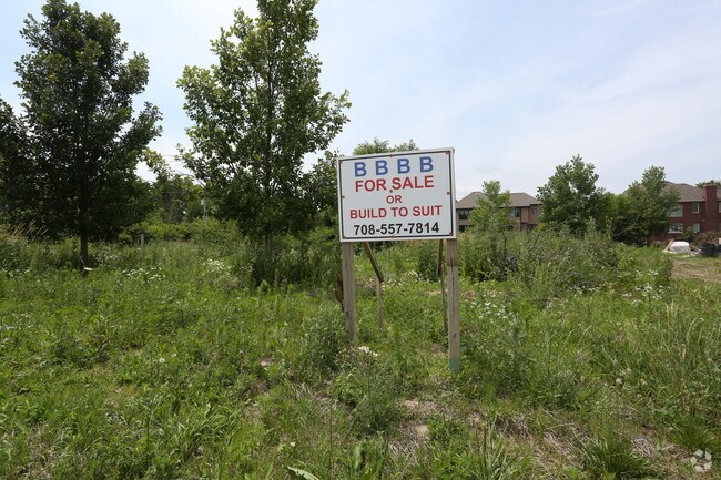
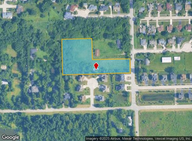
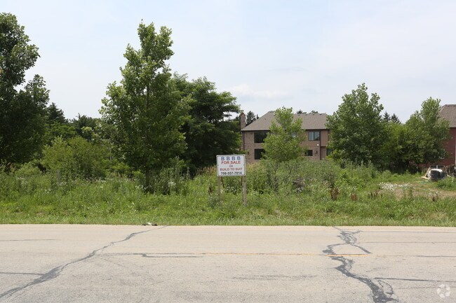
10S330 Clarendon Hills Rd
Chicago-Naperville-Elgin, IL-IN-WI
Downers Grove Twp Supv Assnt Plat
10-03-208-027
DOWNERS GROVE TWP SUPV ASSNT PLAT #5 /EX N 200 FT E 350 FT/
Farms
DuPage
X
Illinois
17043C0277J
2
2024
3.19 AC
2024
Joliet/Central Will
845805
Chicago
DEMOGRAPHICS near 10S330 Clarendon Hills Rd
1 Mile
3 Mile
5 Mile
2024 Total Population
6,639
40,835
154,886
2029 Population
6,517
40,080
152,605
Pop Growth 2024-2029
(1.84%)
(1.85%)
(1.47%)
Average Age
39
44
43
2024 Total Households
2,603
16,466
61,290
HH Growth 2024-2029
(1.81%)
(1.93%)
(1.60%)
Median Household Inc
$77,074
$98,638
$99,098
Avg Household Size
2.50
2.40
2.50
2024 Avg HH Vehicles
2.00
2.00
2.00
Median Home Value
$342,857
$390,293
$385,288
Median Year Built
1977
1977
1978
Nearby Places
Map Layers
Map Styles
 Street
 Aerial
- Restaurants
- Banks
- Shops
- Fitness
- Groceries
PUBLIC TRANSPORTATION
COMMUTER RAIL
Willow Springs Station (Heritage Corridor Line - Northeast Illinois Regional Commuter Railroad (Metra))
DRIVE
WALK
Distance
Willow Springs Station (Heritage Corridor Line - Northeast Illinois Regional Commuter Railroad (Metra))
10 min
6.6 mi
Lemont Station (Heritage Corridor Line - Northeast Illinois Regional Commuter Railroad (Metra))
DRIVE
WALK
Distance
Lemont Station (Heritage Corridor Line - Northeast Illinois Regional Commuter Railroad (Metra))
12 min
7.2 mi
AIRPORT
Chicago Midway International
DRIVE
WALK
Distance
Chicago Midway International
19 min
13.2 mi
Chicago O'Hare International
DRIVE
WALK
Distance
Chicago O'Hare International
36 min
24.6 mi
Freight Ports
Port Milwaukee
DRIVE
WALK
Distance
Port Milwaukee
117 min
96.4 mi
Nearby Properties
Address
Land Use
TOTAL SIZE
Lot Size
Zoning
Address
Land Use
TOTAL SIZE
Lot Size
Zoning
183,080 SF
20.86 AC
C
Address
Land Use
TOTAL SIZE
Lot Size
Zoning
204,824 SF
15.05 AC
Address
Land Use
TOTAL SIZE
Lot Size
Zoning
173,098 SF
16.32 AC
R-6
Address
Land Use
TOTAL SIZE
Lot Size
Zoning
173,459 SF
14.58 AC
C
Address
Land Use
TOTAL SIZE
Lot Size
Zoning
94,064 SF
8.55 AC
Address
Land Use
TOTAL SIZE
Lot Size
Zoning
203,532 SF
6.85 AC
M
Address
Land Use
TOTAL SIZE
Lot Size
Zoning
146,856 SF
7.18 AC
A
Address
Land Use
TOTAL SIZE
Lot Size
Zoning
215,631 SF
23.94 AC
I
Address
Land Use
TOTAL SIZE
Lot Size
Zoning
84,944 SF
6.82 AC
C
Address
Land Use
TOTAL SIZE
Lot Size
Zoning
128,283 SF
6.89 AC
C
Address
Land Use
TOTAL SIZE
Lot Size
Zoning
52,887 SF
4.64 AC
C
Address
Land Use
TOTAL SIZE
Lot Size
Zoning
144,840 SF
3.42 AC
Address
Land Use
TOTAL SIZE
Lot Size
Zoning
188,319 SF
10.09 AC
M
Address
Land Use
TOTAL SIZE
Lot Size
Zoning
129,195 SF
10.71 AC
Address
Land Use
TOTAL SIZE
Lot Size
Zoning
153,000 SF
10.26 AC
Address
Land Use
TOTAL SIZE
Lot Size
Zoning
114,174 SF
15 AC
C
Address
Land Use
TOTAL SIZE
Lot Size
Zoning
105,562 SF
9.64 AC
Address
Land Use
TOTAL SIZE
Lot Size
Zoning
199,392 SF
4.59 AC
M
Address
Land Use
TOTAL SIZE
Lot Size
Zoning
76,745 SF
9.54 AC
C
Address
Land Use
TOTAL SIZE
Lot Size
Zoning
96,758 SF
6.89 AC
Address
Land Use
TOTAL SIZE
Lot Size
Zoning
92,256 SF
7.98 AC
C
Address
Land Use
TOTAL SIZE
Lot Size
Zoning
61,481 SF
3.99 AC
Address
Land Use
TOTAL SIZE
Lot Size
Zoning
76,701 SF
5.02 AC
C
Address
Land Use
TOTAL SIZE
Lot Size
Zoning
136,618 SF
19.66 AC
I
Address
Land Use
TOTAL SIZE
Lot Size
Zoning
47,192 SF
3.38 AC
Address
Land Use
TOTAL SIZE
Lot Size
Zoning
41,600 SF
3.66 AC
C
Address
Land Use
TOTAL SIZE
Lot Size
Zoning
91,439 SF
8.73 AC
C
Address
Land Use
TOTAL SIZE
Lot Size
Zoning
78,860 SF
6.63 AC
C
Address
Land Use
TOTAL SIZE
Lot Size
Zoning
54,000 SF
5.22 AC
I
Address
Land Use
TOTAL SIZE
Lot Size
Zoning
47,976 SF
0.37 AC
C
The World's #1 Commercial Real Estate Marketplace
Connect with us
© 2025 CoStar Group
The information above has been obtained from sources believed reliable. While we do not doubt its accuracy we have not verified it and make no guarantee, warranty or representation about it. It is your responsibility to independently confirm its accuracy and completeness. Any projections, opinions, assumptions, or estimates used are for example only and do not represent the current or future performance of the property. The value of this transaction to you depends on tax and other factors which should be evaluated by your tax, financial, and legal advisors. You and your advisors should conduct a careful, independent investigation of the property to determine to your satisfaction the suitability of the property for your needs.