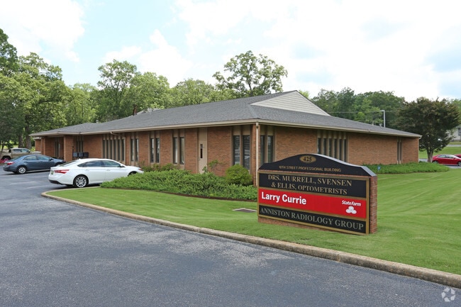
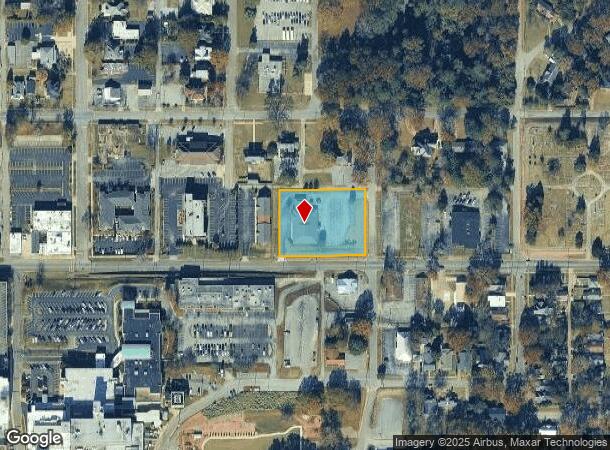
Property Record
10Th East St, Anniston, AL 36201

NEARBY LISTINGS FOR SALE OR LEASE
Property Detail
10Th East St
Anniston-Oxford-Jacksonville, AL
W L Mccaas Subdivision Of Block 55 Accor
21-03-08-1-001-027.000
SEC 08 TSP 16S RNG 08E SATE FARM MUTUAL'S RE-SUB OF LOT'S 8 -13 & P/O LOT 5 OF W W MCCAA'S RE- SUB OF P/O BLK 55 OF ANNI STON
Officebuilding
Calhoun
X
Alabama
01015C0312E
5
2025
1.48 AC
2025
Gadsden/Anniston Area
000400
Other Market Areas
8,416 SF
DEMOGRAPHICS near 10Th East St
1 Mile
3 Mile
5 Mile
2024 Total Population
5,651
24,106
46,268
2029 Population
5,661
24,213
45,977
Pop Growth 2024-2029
+ 0.18%
+ 0.44%
(0.63%)
Average Age
42
42
42
2024 Total Households
2,362
10,211
19,333
HH Growth 2024-2029
+ 0.17%
+ 0.41%
(0.67%)
Median Household Inc
$36,785
$33,387
$40,066
Avg Household Size
2.10
2.10
2.20
2024 Avg HH Vehicles
2.00
2.00
2.00
Median Home Value
$94,486
$91,087
$113,838
Median Year Built
1962
1967
1972
Nearby Places
Map Layers
Map Styles
 Street
 Aerial
- Restaurants
- Banks
- Shops
- Fitness
- Groceries
PUBLIC TRANSPORTATION
COMMUTER RAIL
Anniston Amtrak Station (Crescent - Amtrak)
DRIVE
WALK
Distance
Anniston Amtrak Station (Crescent - Amtrak)
3 min
1.2 mi
Freight Ports
Port of Panama City
DRIVE
WALK
Distance
Port of Panama City
365 min
293.0 mi
Nearby Properties
Address
Land Use
TOTAL SIZE
Lot Size
Zoning
Address
Land Use
TOTAL SIZE
Lot Size
Zoning
319,650 SF
10.69 AC
Address
Land Use
TOTAL SIZE
Lot Size
Zoning
12,496 SF
7.39 AC
Address
Land Use
TOTAL SIZE
Lot Size
Zoning
4,520 SF
8.20 AC
Address
Land Use
TOTAL SIZE
Lot Size
Zoning
73,027 SF
1.60 AC
Address
Land Use
TOTAL SIZE
Lot Size
Zoning
21,766 SF
3.06 AC
Address
Land Use
TOTAL SIZE
Lot Size
Zoning
5.32 AC
Address
Land Use
TOTAL SIZE
Lot Size
Zoning
18.90 AC
Address
Land Use
TOTAL SIZE
Lot Size
Zoning
17,254 SF
22 AC
Address
Land Use
TOTAL SIZE
Lot Size
Zoning
341,374 SF
15.88 AC
Address
Land Use
TOTAL SIZE
Lot Size
Zoning
346,532 SF
41 AC
Address
Land Use
TOTAL SIZE
Lot Size
Zoning
31,832 SF
16 AC
Address
Land Use
TOTAL SIZE
Lot Size
Zoning
14,082 SF
3.85 AC
Address
Land Use
TOTAL SIZE
Lot Size
Zoning
5,581 SF
1.01 AC
Address
Land Use
TOTAL SIZE
Lot Size
Zoning
42,158 SF
5.20 AC
Address
Land Use
TOTAL SIZE
Lot Size
Zoning
3.67 AC
Address
Land Use
TOTAL SIZE
Lot Size
Zoning
71,060 SF
2.20 AC
Address
Land Use
TOTAL SIZE
Lot Size
Zoning
86,508 SF
20 AC
Address
Land Use
TOTAL SIZE
Lot Size
Zoning
103,550 SF
9.15 AC
Address
Land Use
TOTAL SIZE
Lot Size
Zoning
6.94 AC
Address
Land Use
TOTAL SIZE
Lot Size
Zoning
Address
Land Use
TOTAL SIZE
Lot Size
Zoning
227,530 SF
24 AC
Address
Land Use
TOTAL SIZE
Lot Size
Zoning
6,400 SF
12.24 AC
Address
Land Use
TOTAL SIZE
Lot Size
Zoning
30,901 SF
4.30 AC
Address
Land Use
TOTAL SIZE
Lot Size
Zoning
6,912 SF
12.68 AC
Address
Land Use
TOTAL SIZE
Lot Size
Zoning
194,310 SF
9.11 AC
Address
Land Use
TOTAL SIZE
Lot Size
Zoning
Address
Land Use
TOTAL SIZE
Lot Size
Zoning
34,564 SF
1.60 AC
Address
Land Use
TOTAL SIZE
Lot Size
Zoning
10,479 SF
9.56 AC
Address
Land Use
TOTAL SIZE
Lot Size
Zoning
85,305 SF
1.11 AC
Address
Land Use
TOTAL SIZE
Lot Size
Zoning
24,132 SF
5.02 AC
The World's #1 Commercial Real Estate Marketplace
Connect with us
© 2025 CoStar Group
The information above has been obtained from sources believed reliable. While we do not doubt its accuracy we have not verified it and make no guarantee, warranty or representation about it. It is your responsibility to independently confirm its accuracy and completeness. Any projections, opinions, assumptions, or estimates used are for example only and do not represent the current or future performance of the property. The value of this transaction to you depends on tax and other factors which should be evaluated by your tax, financial, and legal advisors. You and your advisors should conduct a careful, independent investigation of the property to determine to your satisfaction the suitability of the property for your needs.