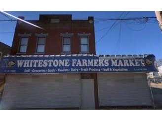
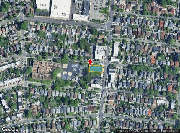
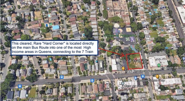
Property Record
11 154Th St, Whitestone, NY 11357

NEARBY LISTINGS FOR SALE OR LEASE
Property Detail
11 154Th St
04538-0070
Beechhurst/Whitestone Lndg
Commercialnec
Queens
X
New York
3604970116F
70
2024
0.18 AC
2025
Northeast Queens
098700
Long Island (New York)
900 SF
New York-Jersey City-White Plains, NY-NJ
DEMOGRAPHICS near 11 154Th St
1 Mile
3 Mile
5 Mile
2024 Total Population
28,066
313,206
1,065,717
2029 Population
26,055
292,276
988,984
Pop Growth 2024-2029
(7.17%)
(6.68%)
(7.20%)
Average Age
46
44
41
2024 Total Households
10,620
112,594
365,951
HH Growth 2024-2029
(7.59%)
(7.05%)
(7.56%)
Median Household Inc
$85,075
$64,247
$63,736
Avg Household Size
2.60
2.70
2.80
2024 Avg HH Vehicles
2.00
1.00
1.00
Median Home Value
$777,574
$709,647
$694,287
Median Year Built
1956
1958
1955
Nearby Places
Map Layers
Map Styles
 Street
 Aerial
- Restaurants
- Banks
- Shops
- Fitness
- Groceries
PUBLIC TRANSPORTATION
COMMUTER RAIL
Broadway Station (Port Washington Branch - Long Island Rail Road)
DRIVE
WALK
Distance
Broadway Station (Port Washington Branch - Long Island Rail Road)
11 min
2.8 mi
Auburndale Station (Port Washington Branch - Long Island Rail Road)
DRIVE
WALK
Distance
Auburndale Station (Port Washington Branch - Long Island Rail Road)
12 min
4.9 mi
AIRPORT
LaGuardia
DRIVE
WALK
Distance
LaGuardia
13 min
6.5 mi
John F Kennedy International
DRIVE
WALK
Distance
John F Kennedy International
16 min
12.6 mi
Westchester County
DRIVE
WALK
Distance
Westchester County
32 min
25.9 mi
Freight Ports
NY - Red Hook Container Terminal
DRIVE
WALK
Distance
NY - Red Hook Container Terminal
1 min
12.7 mi
SALE & LEASE HISTORY
LISTING DATE
SALE/LEASE

Sep 25, 2016
For Lease
Mar 15, 2023
For Sale
Nearby Properties
Address
Land Use
TOTAL SIZE
Lot Size
Zoning
Address
Land Use
TOTAL SIZE
Lot Size
Zoning
703,265 SF
83.45 AC
R4
Address
Land Use
TOTAL SIZE
Lot Size
Zoning
421,996 SF
136.05 AC
R3-1
Address
Land Use
TOTAL SIZE
Lot Size
Zoning
4,050 SF
113.40 AC
PARK
Address
Land Use
TOTAL SIZE
Lot Size
Zoning
332,266 SF
12.57 AC
M2-1
Address
Land Use
TOTAL SIZE
Lot Size
Zoning
14,681 SF
97 AC
PARK
Address
Land Use
TOTAL SIZE
Lot Size
Zoning
510 SF
68.73 AC
PARK
Address
Land Use
TOTAL SIZE
Lot Size
Zoning
250,577 SF
23.17 AC
M2-1
Address
Land Use
TOTAL SIZE
Lot Size
Zoning
198,298 SF
13.93 AC
C4-1
Address
Land Use
TOTAL SIZE
Lot Size
Zoning
186,843 SF
5.37 AC
R2A
Address
Land Use
TOTAL SIZE
Lot Size
Zoning
281,416 SF
2.57 AC
C4-2
Address
Land Use
TOTAL SIZE
Lot Size
Zoning
382,302 SF
6.23 AC
R2A
Address
Land Use
TOTAL SIZE
Lot Size
Zoning
454,631 SF
24.61 AC
M1-1
Address
Land Use
TOTAL SIZE
Lot Size
Zoning
443,492 SF
27.75 AC
M1-1
Address
Land Use
TOTAL SIZE
Lot Size
Zoning
15.83 AC
M2-1
Address
Land Use
TOTAL SIZE
Lot Size
Zoning
202,063 SF
2.79 AC
C4-2
Address
Land Use
TOTAL SIZE
Lot Size
Zoning
1,172,800 SF
19.66 AC
R4
Address
Land Use
TOTAL SIZE
Lot Size
Zoning
164,110 SF
8.07 AC
M1-2
Address
Land Use
TOTAL SIZE
Lot Size
Zoning
109,805 SF
1.96 AC
C4-2
Address
Land Use
TOTAL SIZE
Lot Size
Zoning
303,039 SF
C4-2
Address
Land Use
TOTAL SIZE
Lot Size
Zoning
426,224 SF
4.70 AC
R6
Address
Land Use
TOTAL SIZE
Lot Size
Zoning
170,000 SF
3.03 AC
R7-1
Address
Land Use
TOTAL SIZE
Lot Size
Zoning
222,656 SF
6.03 AC
R5B
Address
Land Use
TOTAL SIZE
Lot Size
Zoning
30,000 SF
0.62 AC
R7-1
Address
Land Use
TOTAL SIZE
Lot Size
Zoning
131,000 SF
3.54 AC
R4
Address
Land Use
TOTAL SIZE
Lot Size
Zoning
127,291 SF
8.07 AC
M1-2
Address
Land Use
TOTAL SIZE
Lot Size
Zoning
146,042 SF
0.50 AC
R6
Address
Land Use
TOTAL SIZE
Lot Size
Zoning
271,294 SF
Address
Land Use
TOTAL SIZE
Lot Size
Zoning
158,282 SF
2.38 AC
R4A
Address
Land Use
TOTAL SIZE
Lot Size
Zoning
136,026 SF
1.49 AC
R3A
Address
Land Use
TOTAL SIZE
Lot Size
Zoning
75,000 SF
0.41 AC
R6
The World's #1 Commercial Real Estate Marketplace
Connect with us
© 2026 CoStar Group
The information above has been obtained from sources believed reliable. While we do not doubt its accuracy we have not verified it and make no guarantee, warranty or representation about it. It is your responsibility to independently confirm its accuracy and completeness. Any projections, opinions, assumptions, or estimates used are for example only and do not represent the current or future performance of the property. The value of this transaction to you depends on tax and other factors which should be evaluated by your tax, financial, and legal advisors. You and your advisors should conduct a careful, independent investigation of the property to determine to your satisfaction the suitability of the property for your needs.