Property Record
11 1St St N, Jacksonville Beach, FL 32250


NEARBY LISTINGS FOR SALE OR LEASE
-
-
View all Jacksonville Beach listings for lease on LoopNet.com
Property Detail
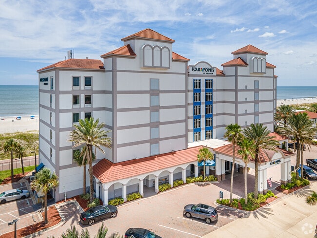
11 1St St N
173993-9350
Pablo Beach North
Hotel
3-28 33-2S-29E 1.28 PABLO BEACH NORTH PT UNDIVIDED BLK 1,PT CLOSED PABLO AVE N LYING N THEREOF RECD O/R 20879-977 BEING PARCEL C-1-A
VE
Duval
12031C0417J
Florida
2025
1.36 AC
2026
Jacksonville Beaches
014104
Jacksonville (Florida)
26,510 SF
Jacksonville, FL
DEMOGRAPHICS near 11 1St St N
1 Mile
3 Mile
5 Mile
2024 Total Population
9,342
41,744
101,659
2029 Population
9,918
44,682
110,165
Pop Growth 2024-2029
+ 6.17%
+ 7.04%
+ 8.37%
Average Age
42
43
42
2024 Total Households
4,825
19,645
45,282
HH Growth 2024-2029
+ 6.47%
+ 7.40%
+ 8.36%
Median Household Inc
$91,707
$95,996
$92,002
Avg Household Size
1.90
2.10
2.20
2024 Avg HH Vehicles
2.00
2.00
2.00
Median Home Value
$440,705
$456,638
$424,064
Median Year Built
1982
1983
1989
Nearby Places
Map Layers
Map Styles
 Street
 Aerial
- Restaurants
- Banks
- Shops
- Fitness
- Groceries
PUBLIC TRANSPORTATION
AIRPORT
Jacksonville International
DRIVE
WALK
Distance
Jacksonville International
43 min
28.4 mi
Freight Ports
Jacksonville Port
DRIVE
WALK
Distance
Jacksonville Port
34 min
18.9 mi
SALE & LEASE HISTORY
LISTING DATE
SALE/LEASE

Sep 25, 2016
For Lease
Nearby Properties
Address
Land Use
TOTAL SIZE
Lot Size
Zoning
Address
Land Use
TOTAL SIZE
Lot Size
Zoning
231,215 SF
22.79 AC
JPUD
Address
Land Use
TOTAL SIZE
Lot Size
Zoning
235,939 SF
11.25 AC
JRM-1
Address
Land Use
TOTAL SIZE
Lot Size
Zoning
312,261 SF
28.54 AC
RG1
Address
Land Use
TOTAL SIZE
Lot Size
Zoning
50,124 SF
2.53 AC
JRM-2
Address
Land Use
TOTAL SIZE
Lot Size
Zoning
298,551 SF
29.03 AC
JPUD
Address
Land Use
TOTAL SIZE
Lot Size
Zoning
214,856 SF
15.07 AC
JPUD
Address
Land Use
TOTAL SIZE
Lot Size
Zoning
115,119 SF
1.14 AC
JRD
Address
Land Use
TOTAL SIZE
Lot Size
Zoning
90,729 SF
0.99 AC
JRD
Address
Land Use
TOTAL SIZE
Lot Size
Zoning
65,384 SF
2.33 AC
ACG
Address
Land Use
TOTAL SIZE
Lot Size
Zoning
244,454 SF
14.76 AC
NR-5
Address
Land Use
TOTAL SIZE
Lot Size
Zoning
265,048 SF
16.20 AC
RMD-D
Address
Land Use
TOTAL SIZE
Lot Size
Zoning
256,228 SF
19.47 AC
PUD
Address
Land Use
TOTAL SIZE
Lot Size
Zoning
215,372 SF
19.20 AC
RG1
Address
Land Use
TOTAL SIZE
Lot Size
Zoning
44,526 SF
1.98 AC
JRM-2
Address
Land Use
TOTAL SIZE
Lot Size
Zoning
166,277 SF
12.41 AC
JC-1
Address
Land Use
TOTAL SIZE
Lot Size
Zoning
203,317 SF
11.96 AC
RMD-D
Address
Land Use
TOTAL SIZE
Lot Size
Zoning
219,659 SF
21.37 AC
NR-1
Address
Land Use
TOTAL SIZE
Lot Size
Zoning
206,190 SF
12.10 AC
RMD-D
Address
Land Use
TOTAL SIZE
Lot Size
Zoning
120,233 SF
14.08 AC
ACG
Address
Land Use
TOTAL SIZE
Lot Size
Zoning
183,674 SF
22.19 AC
PUD
Address
Land Use
TOTAL SIZE
Lot Size
Zoning
122,836 SF
26.31 AC
JPUD
Address
Land Use
TOTAL SIZE
Lot Size
Zoning
74,004 SF
26.19 AC
JI-1
Address
Land Use
TOTAL SIZE
Lot Size
Zoning
136,558 SF
1.89 AC
JC-2
Address
Land Use
TOTAL SIZE
Lot Size
Zoning
68,760 SF
5.73 AC
JPUD
Address
Land Use
TOTAL SIZE
Lot Size
Zoning
106,594 SF
12.06 AC
JPUD
Address
Land Use
TOTAL SIZE
Lot Size
Zoning
104,220 SF
7.80 AC
JI-1
Address
Land Use
TOTAL SIZE
Lot Size
Zoning
17.79 AC
JRS-1
Address
Land Use
TOTAL SIZE
Lot Size
Zoning
128,543 SF
131 AC
PUD
Address
Land Use
TOTAL SIZE
Lot Size
Zoning
80,746 SF
11.68 AC
NC-3
The World's #1 Commercial Real Estate Marketplace
Connect with us
© 2025 CoStar Group
The information above has been obtained from sources believed reliable. While we do not doubt its accuracy we have not verified it and make no guarantee, warranty or representation about it. It is your responsibility to independently confirm its accuracy and completeness. Any projections, opinions, assumptions, or estimates used are for example only and do not represent the current or future performance of the property. The value of this transaction to you depends on tax and other factors which should be evaluated by your tax, financial, and legal advisors. You and your advisors should conduct a careful, independent investigation of the property to determine to your satisfaction the suitability of the property for your needs.