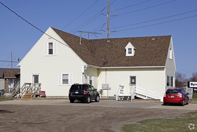
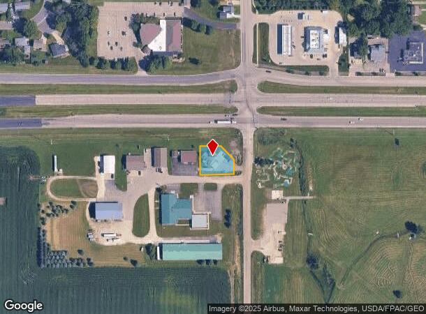
Property Record
11 2Nd Ave Sw, Byron, MN 55920

NEARBY LISTINGS FOR SALE OR LEASE
-
-
View all Byron listings for lease on LoopNet.com
Property Detail
11 2Nd Ave Sw
Rochester, MN
Southwest Industrial Park 1St
75.32.31.059173
SECT-32 TWP-107 RANGE-015 SOUTHWEST INDUSTRIAL PARK 1ST LOT-001 BLOCK-001 .35 AC SOUTHWEST INDUSTRIAL PARK 1ST LOT 1 BLK 1
Wholesaleoutletdiscountstore
Olmsted
X
Minnesota
27039C0200C
1
2025
0.36 AC
2024
Rochester
001800
Other Market Areas
3,344 SF
DEMOGRAPHICS near 11 2Nd Ave Sw
1 Mile
3 Mile
5 Mile
2024 Total Population
4,150
7,118
12,439
2029 Population
4,183
7,233
12,646
Pop Growth 2024-2029
+ 0.80%
+ 1.62%
+ 1.66%
Average Age
37
38
38
2024 Total Households
1,512
2,556
4,484
HH Growth 2024-2029
+ 0.73%
+ 1.49%
+ 1.54%
Median Household Inc
$101,645
$111,086
$106,238
Avg Household Size
2.70
2.80
2.70
2024 Avg HH Vehicles
2.00
2.00
2.00
Median Home Value
$284,492
$322,869
$305,631
Median Year Built
1993
1994
1993
Nearby Places
Map Layers
Map Styles
 Street
 Aerial
- Restaurants
- Banks
- Shops
- Fitness
- Groceries
PUBLIC TRANSPORTATION
AIRPORT
Rochester International
DRIVE
WALK
Distance
Rochester International
24 min
17.9 mi
SALE & LEASE HISTORY
LISTING DATE
SALE/LEASE

Aug 02, 2018
For Lease
Nearby Properties
Address
Land Use
TOTAL SIZE
Lot Size
Zoning
Address
Land Use
TOTAL SIZE
Lot Size
Zoning
576 SF
152.91 AC
Address
Land Use
TOTAL SIZE
Lot Size
Zoning
80,975 SF
43.45 AC
Address
Land Use
TOTAL SIZE
Lot Size
Zoning
2,352 SF
3.97 AC
Address
Land Use
TOTAL SIZE
Lot Size
Zoning
143,657 SF
76.01 AC
Address
Land Use
TOTAL SIZE
Lot Size
Zoning
4,116 SF
2.24 AC
Address
Land Use
TOTAL SIZE
Lot Size
Zoning
53,740 SF
5 AC
Address
Land Use
TOTAL SIZE
Lot Size
Zoning
24,230 SF
4.22 AC
Address
Land Use
TOTAL SIZE
Lot Size
Zoning
64,347 SF
3.73 AC
Address
Land Use
TOTAL SIZE
Lot Size
Zoning
121,600 SF
7.65 AC
Address
Land Use
TOTAL SIZE
Lot Size
Zoning
209.70 AC
Address
Land Use
TOTAL SIZE
Lot Size
Zoning
15,751 SF
8.92 AC
Address
Land Use
TOTAL SIZE
Lot Size
Zoning
1,768 SF
2.34 AC
Address
Land Use
TOTAL SIZE
Lot Size
Zoning
21,386 SF
1.37 AC
Address
Land Use
TOTAL SIZE
Lot Size
Zoning
150.34 AC
Address
Land Use
TOTAL SIZE
Lot Size
Zoning
20,007 SF
4.34 AC
Address
Land Use
TOTAL SIZE
Lot Size
Zoning
53,162 SF
15.69 AC
Address
Land Use
TOTAL SIZE
Lot Size
Zoning
145.31 AC
Address
Land Use
TOTAL SIZE
Lot Size
Zoning
12,396 SF
4.06 AC
Address
Land Use
TOTAL SIZE
Lot Size
Zoning
1,216 SF
150.47 AC
Address
Land Use
TOTAL SIZE
Lot Size
Zoning
120 AC
Address
Land Use
TOTAL SIZE
Lot Size
Zoning
26,040 SF
4.12 AC
Address
Land Use
TOTAL SIZE
Lot Size
Zoning
14,276 SF
4.35 AC
Address
Land Use
TOTAL SIZE
Lot Size
Zoning
140 AC
Address
Land Use
TOTAL SIZE
Lot Size
Zoning
134.45 AC
Address
Land Use
TOTAL SIZE
Lot Size
Zoning
150 AC
Address
Land Use
TOTAL SIZE
Lot Size
Zoning
3,408 SF
160 AC
Address
Land Use
TOTAL SIZE
Lot Size
Zoning
12,126 SF
3.60 AC
Address
Land Use
TOTAL SIZE
Lot Size
Zoning
15,927 SF
0.70 AC
Address
Land Use
TOTAL SIZE
Lot Size
Zoning
23,026 SF
5.84 AC
Address
Land Use
TOTAL SIZE
Lot Size
Zoning
12,000 SF
1.27 AC
The World's #1 Commercial Real Estate Marketplace
Connect with us
© 2025 CoStar Group
The information above has been obtained from sources believed reliable. While we do not doubt its accuracy we have not verified it and make no guarantee, warranty or representation about it. It is your responsibility to independently confirm its accuracy and completeness. Any projections, opinions, assumptions, or estimates used are for example only and do not represent the current or future performance of the property. The value of this transaction to you depends on tax and other factors which should be evaluated by your tax, financial, and legal advisors. You and your advisors should conduct a careful, independent investigation of the property to determine to your satisfaction the suitability of the property for your needs.