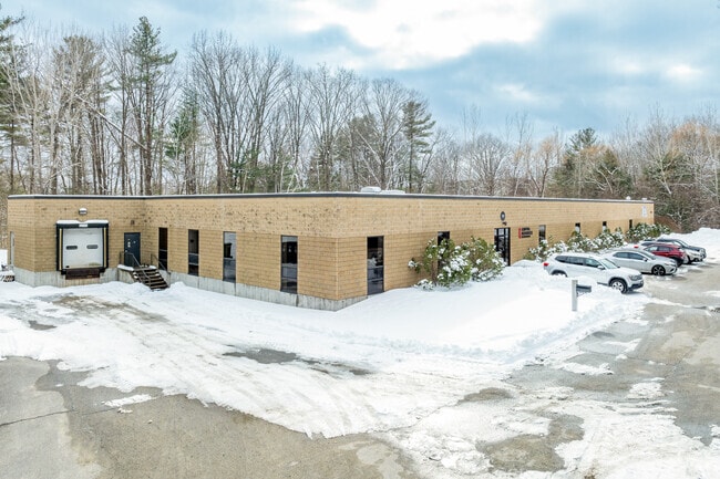
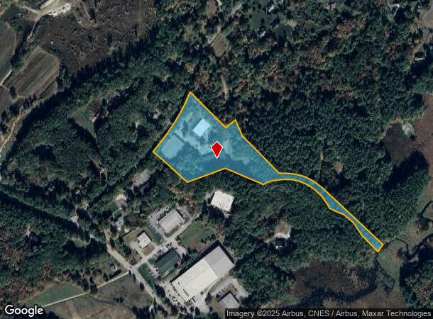
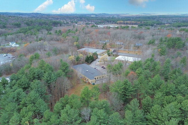
Property Record
9 Beaver Brook Rd, Littleton, MA 01460
Current Lease Availabilities
NEARBY LISTINGS FOR SALE OR LEASE
Property Detail
9 Beaver Brook Rd
LITT-000018R-000014-000011
Middlesex
Taxexempt
Massachusetts
AE
11
25017C0236G
9.86 AC
2025
Groton/Townsend
2025
Boston
324102
Boston-Cambridge-Newton, MA-NH
DEMOGRAPHICS near 9 Beaver Brook Rd
1 Mile
3 Mile
5 Mile
2024 Total Population
1,635
20,317
53,303
2029 Population
1,619
20,165
53,186
Pop Growth 2024-2029
(0.98%)
(0.75%)
(0.22%)
Average Age
42
42
42
2024 Total Households
562
7,475
19,703
HH Growth 2024-2029
(1.07%)
(0.79%)
(0.29%)
Median Household Inc
$194,196
$157,451
$147,837
Avg Household Size
2.90
2.70
2.70
2024 Avg HH Vehicles
2.00
2.00
2.00
Median Home Value
$702,586
$634,777
$646,054
Median Year Built
1986
1981
1983
Nearby Places
- Restaurants
- Banks
- Shops
- Fitness
- Groceries
PUBLIC TRANSPORTATION
COMMUTER RAIL
Littleton/Route 495 (Fitchburg/South Acton Line - Massachusetts Bay Transportation Authority Commuter Rail (Purple Line))
DRIVE
WALK
Distance
Littleton/Route 495 (Fitchburg/South Acton Line - Massachusetts Bay Transportation Authority Commuter Rail (Purple Line))
9 min
3.9 mi
Ayer (Fitchburg/South Acton Line - Massachusetts Bay Transportation Authority Commuter Rail (Purple Line))
DRIVE
WALK
Distance
Ayer (Fitchburg/South Acton Line - Massachusetts Bay Transportation Authority Commuter Rail (Purple Line))
14 min
7.5 mi
AIRPORT
General Edward Lawrence Logan International
DRIVE
WALK
Distance
General Edward Lawrence Logan International
54 min
32.6 mi
Worcester Regional
DRIVE
WALK
Distance
Worcester Regional
48 min
34.7 mi
Manchester Boston Regional
DRIVE
WALK
Distance
Manchester Boston Regional
55 min
34.7 mi
Freight Ports
Port of Boston
DRIVE
WALK
Distance
Port of Boston
54 min
32.7 mi
Nearby Properties
Address
Land Use
TOTAL SIZE
Lot Size
Zoning
Address
Land Use
TOTAL SIZE
Lot Size
Zoning
310,328 SF
22.24 AC
IH
Address
Land Use
TOTAL SIZE
Lot Size
Zoning
236,297 SF
17.62 AC
CH
Address
Land Use
TOTAL SIZE
Lot Size
Zoning
448,759 SF
51.82 AC
IA
Address
Land Use
TOTAL SIZE
Lot Size
Zoning
481,300 SF
69.04 AC
IA
Address
Land Use
TOTAL SIZE
Lot Size
Zoning
279,042 SF
37.90 AC
RA
Address
Land Use
TOTAL SIZE
Lot Size
Zoning
54.50 AC
R
Address
Land Use
TOTAL SIZE
Lot Size
Zoning
171,661 SF
5.46 AC
IB
Address
Land Use
TOTAL SIZE
Lot Size
Zoning
51,888 SF
57.38 AC
LI
Address
Land Use
TOTAL SIZE
Lot Size
Zoning
220,257 SF
24.17 AC
CH
Address
Land Use
TOTAL SIZE
Lot Size
Zoning
39.84 AC
B
Address
Land Use
TOTAL SIZE
Lot Size
Zoning
374,270 SF
62.74 AC
IA
Address
Land Use
TOTAL SIZE
Lot Size
Zoning
137,558 SF
68.80 AC
RA
Address
Land Use
TOTAL SIZE
Lot Size
Zoning
125,160 SF
29.36 AC
R
Address
Land Use
TOTAL SIZE
Lot Size
Zoning
109,556 SF
85.62 AC
RA
Address
Land Use
TOTAL SIZE
Lot Size
Zoning
125,642 SF
5.77 AC
IB
Address
Land Use
TOTAL SIZE
Lot Size
Zoning
291,926 SF
31.78 AC
IH
Address
Land Use
TOTAL SIZE
Lot Size
Zoning
213,950 SF
22.71 AC
I
Address
Land Use
TOTAL SIZE
Lot Size
Zoning
16.44 AC
IA
Address
Land Use
TOTAL SIZE
Lot Size
Zoning
8.21 AC
R
Address
Land Use
TOTAL SIZE
Lot Size
Zoning
155,922 SF
14.61 AC
CH
Address
Land Use
TOTAL SIZE
Lot Size
Zoning
63,420 SF
40.10 AC
RA
Address
Land Use
TOTAL SIZE
Lot Size
Zoning
171,494 SF
15.68 AC
CH
Address
Land Use
TOTAL SIZE
Lot Size
Zoning
130,524 SF
19.74 AC
IH
Address
Land Use
TOTAL SIZE
Lot Size
Zoning
66,447 SF
11.59 AC
B
Address
Land Use
TOTAL SIZE
Lot Size
Zoning
175,718 SF
20.12 AC
IH
Address
Land Use
TOTAL SIZE
Lot Size
Zoning
65,680 SF
7.59 AC
IA
Address
Land Use
TOTAL SIZE
Lot Size
Zoning
672 SF
183.18 AC
IA
Address
Land Use
TOTAL SIZE
Lot Size
Zoning
44,417 SF
2.29 AC
RA
Address
Land Use
TOTAL SIZE
Lot Size
Zoning
94,159 SF
13.31 AC
I
Address
Land Use
TOTAL SIZE
Lot Size
Zoning
98,125 SF
8.97 AC
IA
The World's #1 Commercial Real Estate Marketplace
Connect with us
© 2025 CoStar Group
The information above has been obtained from sources believed reliable. While we do not doubt its accuracy we have not verified it and make no guarantee, warranty or representation about it. It is your responsibility to independently confirm its accuracy and completeness. Any projections, opinions, assumptions, or estimates used are for example only and do not represent the current or future performance of the property. The value of this transaction to you depends on tax and other factors which should be evaluated by your tax, financial, and legal advisors. You and your advisors should conduct a careful, independent investigation of the property to determine to your satisfaction the suitability of the property for your needs.