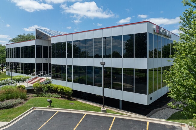
Property Record
11 E Hawthorn Pky, Vernon Hills, IL 60061

NEARBY LISTINGS FOR SALE OR LEASE
Property Detail
11 E Hawthorn Pky
Chicago-Naperville-Elgin, IL-IN
New Century Town Unit One
11-33-303-001
RESUB OF LOT 3 IN NEW CENTURY TOWN UNIT ONE; SUB LOT 1
Commercialbuilding
Lake
X
Illinois
17097C0252K
3,1
2023
4.39 AC
2024
Central North
863902
Chicago
DEMOGRAPHICS near 11 E Hawthorn Pky
1 Mile
3 Mile
5 Mile
2024 Total Population
12,612
66,207
128,988
2029 Population
12,675
66,024
128,318
Pop Growth 2024-2029
+ 0.50%
(0.28%)
(0.52%)
Average Age
41
40
41
2024 Total Households
5,237
24,272
46,953
HH Growth 2024-2029
+ 0.48%
(0.26%)
(0.50%)
Median Household Inc
$96,016
$110,358
$125,363
Avg Household Size
2.40
2.70
2.70
2024 Avg HH Vehicles
2.00
2.00
2.00
Median Home Value
$303,904
$362,660
$415,156
Median Year Built
1986
1983
1984
Nearby Places
Map Layers
Map Styles
 Street
 Aerial
- Restaurants
- Banks
- Shops
- Fitness
- Groceries
PUBLIC TRANSPORTATION
COMMUTER RAIL
Vernon Hills Station (North Central Service - Northeast Illinois Regional Commuter Railroad (Metra))
DRIVE
WALK
Distance
Vernon Hills Station (North Central Service - Northeast Illinois Regional Commuter Railroad (Metra))
6 min
3.0 mi
Mundelein Station (North Central Service - Northeast Illinois Regional Commuter Railroad (Metra))
DRIVE
WALK
Distance
Mundelein Station (North Central Service - Northeast Illinois Regional Commuter Railroad (Metra))
8 min
4.1 mi
AIRPORT
Chicago O'Hare International
DRIVE
WALK
Distance
Chicago O'Hare International
34 min
24.0 mi
Freight Ports
Port Milwaukee
DRIVE
WALK
Distance
Port Milwaukee
71 min
56.4 mi
Nearby Properties
Address
Land Use
TOTAL SIZE
Lot Size
Zoning
Address
Land Use
TOTAL SIZE
Lot Size
Zoning
145.94 AC
Address
Land Use
TOTAL SIZE
Lot Size
Zoning
Address
Land Use
TOTAL SIZE
Lot Size
Zoning
12.96 AC
Address
Land Use
TOTAL SIZE
Lot Size
Zoning
23.12 AC
Address
Land Use
TOTAL SIZE
Lot Size
Zoning
Address
Land Use
TOTAL SIZE
Lot Size
Zoning
Address
Land Use
TOTAL SIZE
Lot Size
Zoning
28.14 AC
Address
Land Use
TOTAL SIZE
Lot Size
Zoning
Address
Land Use
TOTAL SIZE
Lot Size
Zoning
Address
Land Use
TOTAL SIZE
Lot Size
Zoning
Address
Land Use
TOTAL SIZE
Lot Size
Zoning
10.24 AC
Address
Land Use
TOTAL SIZE
Lot Size
Zoning
Address
Land Use
TOTAL SIZE
Lot Size
Zoning
16.20 AC
Address
Land Use
TOTAL SIZE
Lot Size
Zoning
43.14 AC
Address
Land Use
TOTAL SIZE
Lot Size
Zoning
Address
Land Use
TOTAL SIZE
Lot Size
Zoning
43.14 AC
Address
Land Use
TOTAL SIZE
Lot Size
Zoning
10.80 AC
Address
Land Use
TOTAL SIZE
Lot Size
Zoning
22.58 AC
Address
Land Use
TOTAL SIZE
Lot Size
Zoning
12.65 AC
Address
Land Use
TOTAL SIZE
Lot Size
Zoning
13.39 AC
Address
Land Use
TOTAL SIZE
Lot Size
Zoning
840 SF
2.37 AC
Address
Land Use
TOTAL SIZE
Lot Size
Zoning
2.60 AC
Address
Land Use
TOTAL SIZE
Lot Size
Zoning
Address
Land Use
TOTAL SIZE
Lot Size
Zoning
Address
Land Use
TOTAL SIZE
Lot Size
Zoning
Address
Land Use
TOTAL SIZE
Lot Size
Zoning
Address
Land Use
TOTAL SIZE
Lot Size
Zoning
Address
Land Use
TOTAL SIZE
Lot Size
Zoning
Address
Land Use
TOTAL SIZE
Lot Size
Zoning
11.35 AC
Address
Land Use
TOTAL SIZE
Lot Size
Zoning
9.25 AC
The World's #1 Commercial Real Estate Marketplace
Connect with us
© 2026 CoStar Group
The information above has been obtained from sources believed reliable. While we do not doubt its accuracy we have not verified it and make no guarantee, warranty or representation about it. It is your responsibility to independently confirm its accuracy and completeness. Any projections, opinions, assumptions, or estimates used are for example only and do not represent the current or future performance of the property. The value of this transaction to you depends on tax and other factors which should be evaluated by your tax, financial, and legal advisors. You and your advisors should conduct a careful, independent investigation of the property to determine to your satisfaction the suitability of the property for your needs.