Property Record
9 E Main St, Kutztown, PA 19530
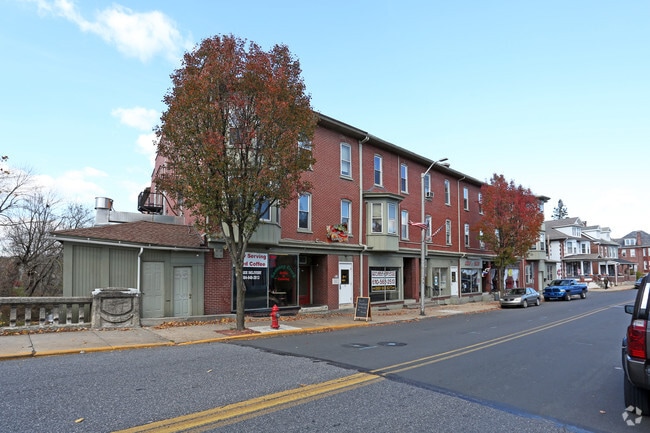

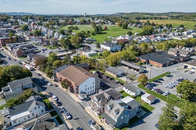
Property Detail
9 E Main St
55-5443-08-88-6366
Berks
Retailwithmorethanonenonretailuse
Pennsylvania
AE The base floodplain where base flood elevations are provided. AE Zones are now used on new format FIRMs instead of A1-A30 Zones.
0.57 AC
2025
Outlying Berks County
2025
Philadelphia
014000
Reading, PA
31,613 SF
NEARBY LISTINGS FOR SALE OR LEASE
-
-
View all Kutztown listings for sale on LoopNet.com
DEMOGRAPHICS near 9 E Main St
1 mile
3 mile
5 mile
2025 Total Population
9,704
13,911
26,831
2030 Population
10,540
14,929
28,318
Pop Growth 2025-2030
+ 8.62%
+ 7.32%
+ 5.54%
Average Age
40
39
41
2025 Total Households
4,091
5,452
10,487
HH Growth 2025-2030
+ 8.92%
+ 8.02%
+ 6.00%
Median Household Inc
$55,508
$57,858
$75,873
Avg Household Size
2.20
2.30
2.30
2025 Avg HH Vehicles
2.00
2.00
2.00
Median Home Value
$258,041
$268,379
$273,929
Median Year Built
1973
1975
1975
Nearby Places
Map Layers
Map Styles
 Street
 Aerial
Transit
 Traffic
 Biking
Places
Listings with unknown addresses are not visible on the map
- Restaurants
- Banks
- Shops
- Fitness
- Groceries
PUBLIC TRANSPORTATION
AIRPORT
Lehigh Valley International
Drive
Walk
Distance
Lehigh Valley International
35 min
22.2 mi
Freight Ports
Port of Philadelphia
Drive
Walk
Distance
Port of Philadelphia
93 min
70.5 mi
SALE & LEASE HISTORY
LISTING DATE
SALE/LEASE

Jun 11, 2020
For Sale
Jan 31, 2019
For Sale
Jan 14, 2019
For Sale
Apr 04, 2019
For Sale
Nearby Properties
Address
Land Use
TOTAL SIZE
Lot Size
Zoning
Address
Land Use
TOTAL SIZE
Lot Size
Zoning
31,697 SF
22.56 AC
Address
Land Use
TOTAL SIZE
Lot Size
Zoning
159,366 SF
0.74 AC
Address
Land Use
TOTAL SIZE
Lot Size
Zoning
1,296,835 SF
265.85 AC
Address
Land Use
TOTAL SIZE
Lot Size
Zoning
69,966 SF
30.10 AC
Address
Land Use
TOTAL SIZE
Lot Size
Zoning
53,353 SF
3.81 AC
Address
Land Use
TOTAL SIZE
Lot Size
Zoning
33,632 SF
2.90 AC
Address
Land Use
TOTAL SIZE
Lot Size
Zoning
21,840 SF
16.68 AC
Address
Land Use
TOTAL SIZE
Lot Size
Zoning
40,772 SF
11.19 AC
Address
Land Use
TOTAL SIZE
Lot Size
Zoning
120,641 SF
12.95 AC
Address
Land Use
TOTAL SIZE
Lot Size
Zoning
38,956 SF
4.90 AC
Address
Land Use
TOTAL SIZE
Lot Size
Zoning
10,770 SF
13.06 AC
Address
Land Use
TOTAL SIZE
Lot Size
Zoning
39,104 SF
4.06 AC
Address
Land Use
TOTAL SIZE
Lot Size
Zoning
245,468 SF
9.93 AC
Address
Land Use
TOTAL SIZE
Lot Size
Zoning
13,440 SF
8.23 AC
Address
Land Use
TOTAL SIZE
Lot Size
Zoning
45,423 SF
17.25 AC
Address
Land Use
TOTAL SIZE
Lot Size
Zoning
266,451 SF
59.37 AC
Address
Land Use
TOTAL SIZE
Lot Size
Zoning
7,806 SF
0.50 AC
Address
Land Use
TOTAL SIZE
Lot Size
Zoning
27,880 SF
16.60 AC
Address
Land Use
TOTAL SIZE
Lot Size
Zoning
12,692 SF
3.68 AC
Address
Land Use
TOTAL SIZE
Lot Size
Zoning
14,797 SF
1.45 AC
Address
Land Use
TOTAL SIZE
Lot Size
Zoning
33,100 SF
5.58 AC
Address
Land Use
TOTAL SIZE
Lot Size
Zoning
221,411 SF
23.93 AC
Address
Land Use
TOTAL SIZE
Lot Size
Zoning
68,606 SF
10.15 AC
Address
Land Use
TOTAL SIZE
Lot Size
Zoning
9,253 SF
226.13 AC
Address
Land Use
TOTAL SIZE
Lot Size
Zoning
15,458 SF
1.45 AC
Address
Land Use
TOTAL SIZE
Lot Size
Zoning
17,072 SF
1.41 AC
Address
Land Use
TOTAL SIZE
Lot Size
Zoning
10,431 SF
75.73 AC
Address
Land Use
TOTAL SIZE
Lot Size
Zoning
38,357 SF
4.95 AC
Address
Land Use
TOTAL SIZE
Lot Size
Zoning
13.88 AC
Address
Land Use
TOTAL SIZE
Lot Size
Zoning
17,379 SF
9.59 AC
The World's #1 Commercial Real Estate Marketplace
Connect with us
© 2026 CoStar Group
The information above has been obtained from sources believed reliable. While we do not doubt its accuracy we have not verified it and make no guarantee, warranty or representation about it. It is your responsibility to independently confirm its accuracy and completeness. Any projections, opinions, assumptions, or estimates used are for example only and do not represent the current or future performance of the property. The value of this transaction to you depends on tax and other factors which should be evaluated by your tax, financial, and legal advisors. You and your advisors should conduct a careful, independent investigation of the property to determine to your satisfaction the suitability of the property for your needs.