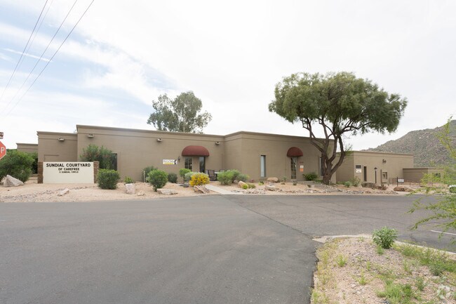
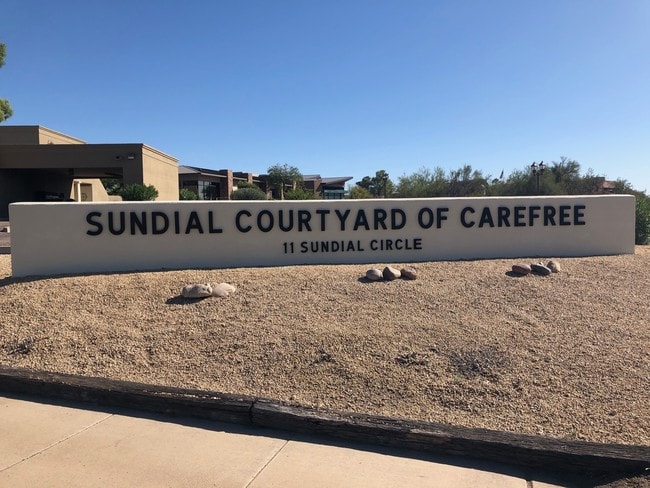
Property Record
11 E Sundial Cir, Carefree, AZ 85377
NEARBY LISTINGS FOR SALE OR LEASE
Property Detail
11 E Sundial Cir
Phoenix-Mesa-Chandler, AZ
Carefree Arizona
216-83-049
CAREFREE ARIZONA MCR 80/27
Officebuilding
Maricopa
X
Arizona
04013C0883L
b
2025
1 AC
2025
N Scottsdale/Carefree
030401
Phoenix
18,423 SF
DEMOGRAPHICS near 11 E Sundial Cir
1 Mile
3 Mile
5 Mile
2024 Total Population
2,107
16,257
38,250
2029 Population
2,330
18,126
42,407
Pop Growth 2024-2029
+ 10.58%
+ 11.50%
+ 10.87%
Average Age
60
59
55
2024 Total Households
1,045
7,690
16,983
HH Growth 2024-2029
+ 10.62%
+ 11.60%
+ 11.13%
Median Household Inc
$122,834
$131,657
$142,591
Avg Household Size
2.00
2.10
2.20
2024 Avg HH Vehicles
2.00
2.00
2.00
Median Home Value
$870,370
$844,520
$833,836
Median Year Built
1988
1997
2000
Nearby Places
Map Layers
Map Styles
 Street
 Aerial
- Restaurants
- Banks
- Shops
- Fitness
- Groceries
PUBLIC TRANSPORTATION
AIRPORT
Phoenix Sky Harbor International
DRIVE
WALK
Distance
Phoenix Sky Harbor International
52 min
34.2 mi
Freight Ports
Port of San Diego
DRIVE
WALK
Distance
Port of San Diego
436 min
383.6 mi
SALE & LEASE HISTORY
LISTING DATE
SALE/LEASE

Oct 12, 2019
For Lease
Mar 27, 2017
For Lease
Feb 22, 2021
For Lease
Nearby Properties
Address
Land Use
TOTAL SIZE
Lot Size
Zoning
Address
Land Use
TOTAL SIZE
Lot Size
Zoning
170,385 SF
23.82 AC
C-C
Address
Land Use
TOTAL SIZE
Lot Size
Zoning
140,303 SF
29.18 AC
R-4R
Address
Land Use
TOTAL SIZE
Lot Size
Zoning
123,518 SF
14.92 AC
C-C
Address
Land Use
TOTAL SIZE
Lot Size
Zoning
223,188 SF
13.68 AC
RT
Address
Land Use
TOTAL SIZE
Lot Size
Zoning
82,175 SF
8.65 AC
C-C
Address
Land Use
TOTAL SIZE
Lot Size
Zoning
47,830 SF
5.22 AC
R-43
Address
Land Use
TOTAL SIZE
Lot Size
Zoning
84,248 SF
6.68 AC
C-C
Address
Land Use
TOTAL SIZE
Lot Size
Zoning
35,734 SF
10.13 AC
R-43
Address
Land Use
TOTAL SIZE
Lot Size
Zoning
32,944 SF
6.89 AC
R-70
Address
Land Use
TOTAL SIZE
Lot Size
Zoning
65,744 SF
2.05 AC
Address
Land Use
TOTAL SIZE
Lot Size
Zoning
21,828 SF
58.46 AC
R-43
Address
Land Use
TOTAL SIZE
Lot Size
Zoning
15,261 SF
13.02 AC
R135
Address
Land Use
TOTAL SIZE
Lot Size
Zoning
31,318 SF
5.37 AC
C-C
Address
Land Use
TOTAL SIZE
Lot Size
Zoning
27,058 SF
8.21 AC
O-S
Address
Land Use
TOTAL SIZE
Lot Size
Zoning
2.88 AC
R-43
Address
Land Use
TOTAL SIZE
Lot Size
Zoning
12.46 AC
C-C
Address
Land Use
TOTAL SIZE
Lot Size
Zoning
90,526 SF
32.62 AC
R-190
Address
Land Use
TOTAL SIZE
Lot Size
Zoning
12,832 SF
5.44 AC
RURAL43
Address
Land Use
TOTAL SIZE
Lot Size
Zoning
35,680 SF
5.91 AC
RT
Address
Land Use
TOTAL SIZE
Lot Size
Zoning
9.27 AC
RT
Address
Land Use
TOTAL SIZE
Lot Size
Zoning
29,792 SF
3.42 AC
C-T
Address
Land Use
TOTAL SIZE
Lot Size
Zoning
1.10 AC
R35
Address
Land Use
TOTAL SIZE
Lot Size
Zoning
7.65 AC
RT
Address
Land Use
TOTAL SIZE
Lot Size
Zoning
29,535 SF
2.07 AC
C-C
Address
Land Use
TOTAL SIZE
Lot Size
Zoning
8,277 SF
4.26 AC
R-35
Address
Land Use
TOTAL SIZE
Lot Size
Zoning
31,283 SF
3 AC
C-T
Address
Land Use
TOTAL SIZE
Lot Size
Zoning
11,524 SF
60.04 AC
OS
Address
Land Use
TOTAL SIZE
Lot Size
Zoning
3,043 SF
9.09 AC
R-89
Address
Land Use
TOTAL SIZE
Lot Size
Zoning
44,849 SF
1.70 AC
M-L
The World's #1 Commercial Real Estate Marketplace
Connect with us
© 2026 CoStar Group
The information above has been obtained from sources believed reliable. While we do not doubt its accuracy we have not verified it and make no guarantee, warranty or representation about it. It is your responsibility to independently confirm its accuracy and completeness. Any projections, opinions, assumptions, or estimates used are for example only and do not represent the current or future performance of the property. The value of this transaction to you depends on tax and other factors which should be evaluated by your tax, financial, and legal advisors. You and your advisors should conduct a careful, independent investigation of the property to determine to your satisfaction the suitability of the property for your needs.