Property Record
150 Spruce St, Patchogue, NY 11772
NEARBY LISTINGS FOR SALE OR LEASE
-
-
View all Patchogue listings for sale on LoopNet.com
Property Detail
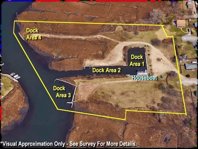
150 Spruce St
Nassau County-Suffolk County, NY
Patchogue (A To L)
0200-979-40-05-00-018-004
N BUTTNER E EVERLAND RLY S EVERLAND
Residentialacreage
Suffolk
AE
New York
36103C0713H
18
0
3 AC
2024
Central Suffolk
159109
Long Island (New York)
DEMOGRAPHICS near 150 Spruce St
1 Mile
3 Mile
5 Mile
2024 Total Population
8,563
60,755
129,477
2029 Population
8,412
60,165
128,251
Pop Growth 2024-2029
(1.76%)
(0.97%)
(0.95%)
Average Age
42
42
42
2024 Total Households
3,314
22,873
46,369
HH Growth 2024-2029
(2.11%)
(1.21%)
(1.16%)
Median Household Inc
$93,404
$100,321
$108,817
Avg Household Size
2.50
2.50
2.70
2024 Avg HH Vehicles
2.00
2.00
2.00
Median Home Value
$417,771
$436,287
$455,756
Median Year Built
1958
1971
1973
Nearby Places
Map Layers
Map Styles
 Street
 Aerial
- Restaurants
- Banks
- Shops
- Fitness
- Groceries
PUBLIC TRANSPORTATION
COMMUTER RAIL
Patchogue Station (Montauk Branch - Long Island Rail Road)
DRIVE
WALK
Distance
Patchogue Station (Montauk Branch - Long Island Rail Road)
5 min
2.0 mi
Bellport Station (Montauk Branch - Long Island Rail Road)
DRIVE
WALK
Distance
Bellport Station (Montauk Branch - Long Island Rail Road)
7 min
3.5 mi
AIRPORT
Long Island MacArthur
DRIVE
WALK
Distance
Long Island MacArthur
17 min
8.2 mi
Freight Ports
Port of New Haven
DRIVE
WALK
Distance
Port of New Haven
137 min
52.9 mi
SALE & LEASE HISTORY
LISTING DATE
SALE/LEASE

Oct 18, 2018
For Sale
Nearby Properties
Address
Land Use
TOTAL SIZE
Lot Size
Zoning
Address
Land Use
TOTAL SIZE
Lot Size
Zoning
30.25 AC
CA
Address
Land Use
TOTAL SIZE
Lot Size
Zoning
33.47 AC
AA
Address
Land Use
TOTAL SIZE
Lot Size
Zoning
7,290 SF
15.71 AC
CA
Address
Land Use
TOTAL SIZE
Lot Size
Zoning
14.70 AC
BUS3
Address
Land Use
TOTAL SIZE
Lot Size
Zoning
9,148 SF
10.30 AC
CA
Address
Land Use
TOTAL SIZE
Lot Size
Zoning
3,278 SF
0.51 AC
VILLA
Address
Land Use
TOTAL SIZE
Lot Size
Zoning
3,942 SF
0.45 AC
VILLA
Address
Land Use
TOTAL SIZE
Lot Size
Zoning
13.39 AC
C
Address
Land Use
TOTAL SIZE
Lot Size
Zoning
2,432 SF
21.76 AC
IND1
Address
Land Use
TOTAL SIZE
Lot Size
Zoning
4.23 AC
IND1
Address
Land Use
TOTAL SIZE
Lot Size
Zoning
11.14 AC
IND1
Address
Land Use
TOTAL SIZE
Lot Size
Zoning
8.10 AC
GSC
Address
Land Use
TOTAL SIZE
Lot Size
Zoning
3,960 SF
0.72 AC
R40
Address
Land Use
TOTAL SIZE
Lot Size
Zoning
2,946 SF
1.04 AC
R20
Address
Land Use
TOTAL SIZE
Lot Size
Zoning
5.31 AC
C
Address
Land Use
TOTAL SIZE
Lot Size
Zoning
5.23 AC
C
Address
Land Use
TOTAL SIZE
Lot Size
Zoning
28.97 AC
Address
Land Use
TOTAL SIZE
Lot Size
Zoning
49.98 AC
BUS1
Address
Land Use
TOTAL SIZE
Lot Size
Zoning
1 AC
R40
Address
Land Use
TOTAL SIZE
Lot Size
Zoning
26.20 AC
Address
Land Use
TOTAL SIZE
Lot Size
Zoning
2,880 SF
0.40 AC
VB
Address
Land Use
TOTAL SIZE
Lot Size
Zoning
Address
Land Use
TOTAL SIZE
Lot Size
Zoning
8.30 AC
Address
Land Use
TOTAL SIZE
Lot Size
Zoning
5.08 AC
IND1
Address
Land Use
TOTAL SIZE
Lot Size
Zoning
4.13 AC
BUS1
Address
Land Use
TOTAL SIZE
Lot Size
Zoning
2,444 SF
0.17 AC
VILLA
Address
Land Use
TOTAL SIZE
Lot Size
Zoning
8.80 AC
IND1
Address
Land Use
TOTAL SIZE
Lot Size
Zoning
32.52 AC
Address
Land Use
TOTAL SIZE
Lot Size
Zoning
3.48 AC
BUS3
Address
Land Use
TOTAL SIZE
Lot Size
Zoning
0.02 AC
R40
The World's #1 Commercial Real Estate Marketplace
Connect with us
© 2025 CoStar Group
The information above has been obtained from sources believed reliable. While we do not doubt its accuracy we have not verified it and make no guarantee, warranty or representation about it. It is your responsibility to independently confirm its accuracy and completeness. Any projections, opinions, assumptions, or estimates used are for example only and do not represent the current or future performance of the property. The value of this transaction to you depends on tax and other factors which should be evaluated by your tax, financial, and legal advisors. You and your advisors should conduct a careful, independent investigation of the property to determine to your satisfaction the suitability of the property for your needs.