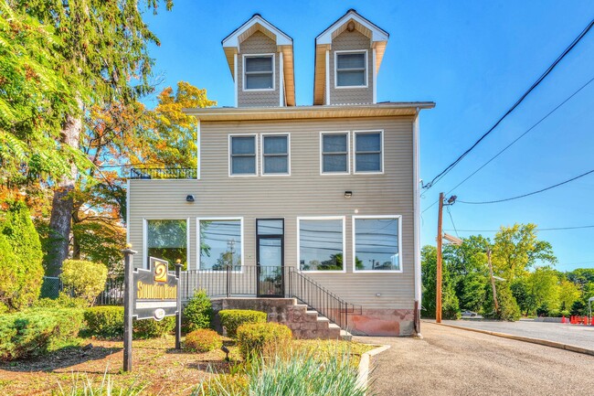
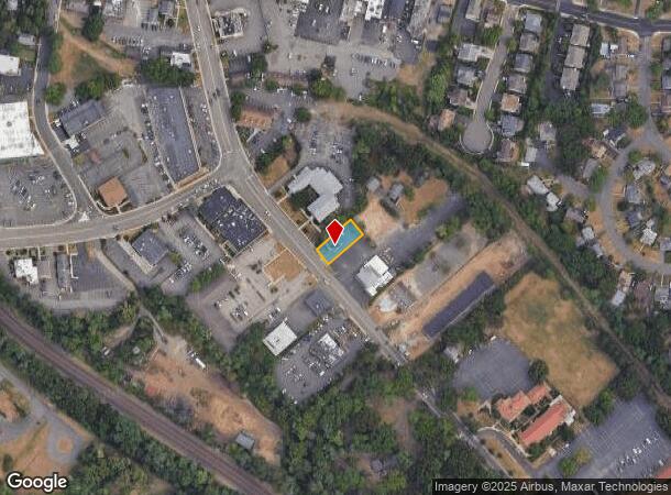
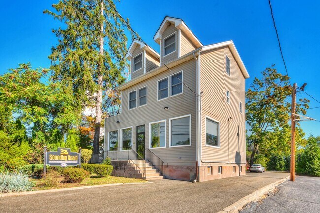
Property Record
11 Franklin Tpke, Waldwick, NJ 07463
NEARBY LISTINGS FOR SALE OR LEASE
Property Detail
11 Franklin Tpke
64-00018-01-00012
50X125 2.5LT
Commercialnec
Bergen
X
New Jersey
34003C0088J
12
2024
0.14 AC
2025
Northwest Bergen
056100
Northern New Jersey
2,182 SF
New York-Jersey City-White Plains, NY-NJ
DEMOGRAPHICS near 11 Franklin Tpke
1 Mile
3 Mile
5 Mile
2024 Total Population
13,410
81,288
225,895
2029 Population
13,360
81,179
224,989
Pop Growth 2024-2029
(0.37%)
(0.13%)
(0.40%)
Average Age
40
42
43
2024 Total Households
4,538
27,924
79,753
HH Growth 2024-2029
(0.42%)
(0.21%)
(0.52%)
Median Household Inc
$154,677
$163,975
$147,394
Avg Household Size
2.90
2.90
2.80
2024 Avg HH Vehicles
2.00
2.00
2.00
Median Home Value
$672,391
$764,602
$719,334
Median Year Built
1953
1957
1960
Nearby Places
Map Layers
Map Styles
 Street
 Aerial
- Restaurants
- Banks
- Shops
- Fitness
- Groceries
PUBLIC TRANSPORTATION
COMMUTER RAIL
Waldwick (Bergen County/Port Jervis Line - NJ Transit Commuter Rail (NJ Transit), Main/Port Jervis Line - NJ Transit Commuter Rail (NJ Transit))
DRIVE
WALK
Distance
Waldwick (Bergen County/Port Jervis Line - NJ Transit Commuter Rail (NJ Transit), Main/Port Jervis Line - NJ Transit Commuter Rail (NJ Transit))
1 min
8 min
0.5 mi
Ho-Ho-Kus (Bergen County/Port Jervis Line - NJ Transit Commuter Rail (NJ Transit), Main/Port Jervis Line - NJ Transit Commuter Rail (NJ Transit))
DRIVE
WALK
Distance
Ho-Ho-Kus (Bergen County/Port Jervis Line - NJ Transit Commuter Rail (NJ Transit), Main/Port Jervis Line - NJ Transit Commuter Rail (NJ Transit))
2 min
18 min
0.9 mi
AIRPORT
LaGuardia
DRIVE
WALK
Distance
LaGuardia
41 min
26.2 mi
Newark Liberty International
DRIVE
WALK
Distance
Newark Liberty International
34 min
26.5 mi
Westchester County
DRIVE
WALK
Distance
Westchester County
52 min
34.2 mi
Freight Ports
Port Newark Container Terminal
DRIVE
WALK
Distance
Port Newark Container Terminal
41 min
28.1 mi
SALE & LEASE HISTORY
LISTING DATE
SALE/LEASE

Oct 21, 2022
For Lease
May 26, 2021
For Lease
Nearby Properties
Address
Land Use
TOTAL SIZE
Lot Size
Zoning
Address
Land Use
TOTAL SIZE
Lot Size
Zoning
15.57 AC
H
Address
Land Use
TOTAL SIZE
Lot Size
Zoning
131,384 SF
65 AC
EO
Address
Land Use
TOTAL SIZE
Lot Size
Zoning
2,252 SF
19.04 AC
Address
Land Use
TOTAL SIZE
Lot Size
Zoning
205,580 SF
21.18 AC
EO
Address
Land Use
TOTAL SIZE
Lot Size
Zoning
40.40 AC
PU
Address
Land Use
TOTAL SIZE
Lot Size
Zoning
80.80 AC
Address
Land Use
TOTAL SIZE
Lot Size
Zoning
23.19 AC
R1
Address
Land Use
TOTAL SIZE
Lot Size
Zoning
20.30 AC
Address
Land Use
TOTAL SIZE
Lot Size
Zoning
3,165 SF
2.07 AC
VC2
Address
Land Use
TOTAL SIZE
Lot Size
Zoning
9.58 AC
R125
Address
Land Use
TOTAL SIZE
Lot Size
Zoning
10.64 AC
AAA
Address
Land Use
TOTAL SIZE
Lot Size
Zoning
Address
Land Use
TOTAL SIZE
Lot Size
Zoning
2.67 AC
AH2
Address
Land Use
TOTAL SIZE
Lot Size
Zoning
124,528 SF
8.87 AC
EM
Address
Land Use
TOTAL SIZE
Lot Size
Zoning
3.63 AC
Address
Land Use
TOTAL SIZE
Lot Size
Zoning
52,908 SF
13.37 AC
BG
Address
Land Use
TOTAL SIZE
Lot Size
Zoning
6.11 AC
OB1
Address
Land Use
TOTAL SIZE
Lot Size
Zoning
99,832 SF
10.39 AC
E
Address
Land Use
TOTAL SIZE
Lot Size
Zoning
74,278 SF
6.91 AC
C2
Address
Land Use
TOTAL SIZE
Lot Size
Zoning
107,584 SF
9.19 AC
EM
Address
Land Use
TOTAL SIZE
Lot Size
Zoning
10.94 AC
AA
Address
Land Use
TOTAL SIZE
Lot Size
Zoning
2 AC
R110
Address
Land Use
TOTAL SIZE
Lot Size
Zoning
13.39 AC
R2
Address
Land Use
TOTAL SIZE
Lot Size
Zoning
129,119 SF
8.23 AC
B3
Address
Land Use
TOTAL SIZE
Lot Size
Zoning
32.37 AC
R1
Address
Land Use
TOTAL SIZE
Lot Size
Zoning
Address
Land Use
TOTAL SIZE
Lot Size
Zoning
26.70 AC
Address
Land Use
TOTAL SIZE
Lot Size
Zoning
1.49 AC
GB
Address
Land Use
TOTAL SIZE
Lot Size
Zoning
2.04 AC
B3R
Address
Land Use
TOTAL SIZE
Lot Size
Zoning
3.85 AC
The World's #1 Commercial Real Estate Marketplace
Connect with us
© 2025 CoStar Group
The information above has been obtained from sources believed reliable. While we do not doubt its accuracy we have not verified it and make no guarantee, warranty or representation about it. It is your responsibility to independently confirm its accuracy and completeness. Any projections, opinions, assumptions, or estimates used are for example only and do not represent the current or future performance of the property. The value of this transaction to you depends on tax and other factors which should be evaluated by your tax, financial, and legal advisors. You and your advisors should conduct a careful, independent investigation of the property to determine to your satisfaction the suitability of the property for your needs.