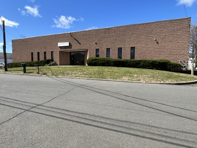
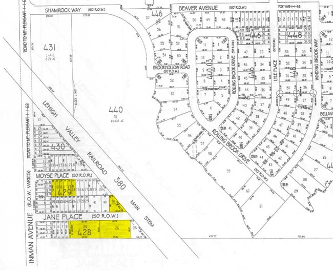
Property Record
11 Jane Pl, Edison, NJ 08820


Current Lease Availabilities
Property Detail
11 Jane Pl
Lakewood-New Brunswick, NJ
188X105
05-00428-0000-00025
Middlesex
Warehouse
New Jersey
LB
25
B and X Area of moderate flood hazard, usually the area between the limits of the 100-year and 500-year floods.
0.45 AC
2024
Exit 10
2025
Northern New Jersey
001412
NEARBY LISTINGS FOR SALE OR LEASE
DEMOGRAPHICS near 11 Jane Pl
1 mile
3 mile
5 mile
2025 Total Population
11,768
118,789
397,337
2030 Population
12,253
124,560
415,514
Pop Growth 2025-2030
+ 4.12%
+ 4.86%
+ 4.57%
Average Age
41
41
40
2025 Total Households
3,889
39,219
135,847
HH Growth 2025-2030
+ 4.24%
+ 5.01%
+ 4.71%
Median Household Inc
$164,338
$139,968
$121,709
Avg Household Size
3.00
2.90
2.80
2025 Avg HH Vehicles
2.00
2.00
2.00
Median Home Value
$634,784
$595,065
$542,522
Median Year Built
1984
1965
1961
Nearby Places
Map Layers
Map Styles
 Street
 Aerial
Layers
 Traffic
 Biking
Places
Listings with unknown addresses are not visible on the map
- Restaurants
- Banks
- Shops
- Fitness
- Groceries
PUBLIC TRANSPORTATION
COMMUTER RAIL
Netherwood (Raritan Valley Line - NJ Transit Commuter Rail (NJ Transit))
Drive
Walk
Distance
Netherwood (Raritan Valley Line - NJ Transit Commuter Rail (NJ Transit))
9 min
3.9 mi
Metropark (Northeast Corridor Line - NJ Transit Commuter Rail (NJ Transit))
Drive
Walk
Distance
Metropark (Northeast Corridor Line - NJ Transit Commuter Rail (NJ Transit))
9 min
4.1 mi
AIRPORT
Newark Liberty International
Drive
Walk
Distance
Newark Liberty International
27 min
18.1 mi
LaGuardia
Drive
Walk
Distance
LaGuardia
61 min
37.3 mi
Freight Ports
New York Container Terminal
Drive
Walk
Distance
New York Container Terminal
24 min
13.7 mi
Nearby Properties
Address
Land Use
TOTAL SIZE
Lot Size
Zoning
Address
Land Use
TOTAL SIZE
Lot Size
Zoning
37.46 AC
EI
Address
Land Use
TOTAL SIZE
Lot Size
Zoning
80,000 SF
23.37 AC
R50
Address
Land Use
TOTAL SIZE
Lot Size
Zoning
96.22 AC
RA
Address
Land Use
TOTAL SIZE
Lot Size
Zoning
5,645 SF
91.16 AC
O
Address
Land Use
TOTAL SIZE
Lot Size
Zoning
9.98 AC
RA
Address
Land Use
TOTAL SIZE
Lot Size
Zoning
30.80 AC
R10
Address
Land Use
TOTAL SIZE
Lot Size
Zoning
102,200 SF
6.68 AC
RA
Address
Land Use
TOTAL SIZE
Lot Size
Zoning
4.74 AC
NC
Address
Land Use
TOTAL SIZE
Lot Size
Zoning
19.50 AC
LR
Address
Land Use
TOTAL SIZE
Lot Size
Zoning
19.19 AC
R-3
Address
Land Use
TOTAL SIZE
Lot Size
Zoning
66,900 SF
12.75 AC
Address
Land Use
TOTAL SIZE
Lot Size
Zoning
21.60 AC
M3
Address
Land Use
TOTAL SIZE
Lot Size
Zoning
20.27 AC
PB
Address
Land Use
TOTAL SIZE
Lot Size
Zoning
43.03 AC
R-1
Address
Land Use
TOTAL SIZE
Lot Size
Zoning
1.46 AC
GB
Address
Land Use
TOTAL SIZE
Lot Size
Zoning
18.03 AC
LR
Address
Land Use
TOTAL SIZE
Lot Size
Zoning
16.69 AC
LR
Address
Land Use
TOTAL SIZE
Lot Size
Zoning
5.46 AC
RA
Address
Land Use
TOTAL SIZE
Lot Size
Zoning
1,092 SF
85.80 AC
Address
Land Use
TOTAL SIZE
Lot Size
Zoning
5.48 AC
RO
Address
Land Use
TOTAL SIZE
Lot Size
Zoning
50.50 AC
O
Address
Land Use
TOTAL SIZE
Lot Size
Zoning
11.50 AC
UR
Address
Land Use
TOTAL SIZE
Lot Size
Zoning
12.31 AC
P
Address
Land Use
TOTAL SIZE
Lot Size
Zoning
18.02 AC
OBC3
Address
Land Use
TOTAL SIZE
Lot Size
Zoning
316.14 AC
Address
Land Use
TOTAL SIZE
Lot Size
Zoning
12.01 AC
Address
Land Use
TOTAL SIZE
Lot Size
Zoning
139,939 SF
16.22 AC
OBC4
Address
Land Use
TOTAL SIZE
Lot Size
Zoning
4.41 AC
CG
Address
Land Use
TOTAL SIZE
Lot Size
Zoning
34.57 AC
M3
Address
Land Use
TOTAL SIZE
Lot Size
Zoning
The World's #1 Commercial Real Estate Marketplace
Connect with us
© 2026 CoStar Group
The information above has been obtained from sources believed reliable. While we do not doubt its accuracy we have not verified it and make no guarantee, warranty or representation about it. It is your responsibility to independently confirm its accuracy and completeness. Any projections, opinions, assumptions, or estimates used are for example only and do not represent the current or future performance of the property. The value of this transaction to you depends on tax and other factors which should be evaluated by your tax, financial, and legal advisors. You and your advisors should conduct a careful, independent investigation of the property to determine to your satisfaction the suitability of the property for your needs.