Property Record
11 Maple Ave, Warwick, NY 10990
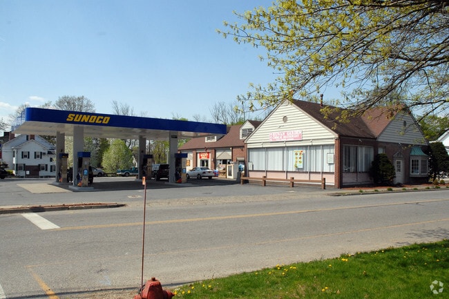

Property Detail
11 Maple Ave
335405-207-000-0002-010.120-0000
LTS 2 3 LAWRENCE SUB 6568
Supermarket
Orange
00401
New York
B and X Area of moderate flood hazard, usually the area between the limits of the 100-year and 500-year floods.
10.12
2024
0.64 AC
2024
Monroe
014602
Northern New Jersey
6,240 SF
Kiryas Joel-Poughkeepsie-Newburgh, NY
NEARBY LISTINGS FOR SALE OR LEASE
-
-
View all Warwick listings for sale on LoopNet.com
DEMOGRAPHICS near 11 Maple Ave
1 mile
3 mile
5 mile
2024 Total Population
5,241
12,703
28,822
2029 Population
5,284
12,867
29,277
Pop Growth 2024-2029
+ 0.82%
+ 1.29%
+ 1.58%
Average Age
45
45
44
2024 Total Households
2,312
5,128
11,206
HH Growth 2024-2029
+ 0.99%
+ 1.38%
+ 1.66%
Median Household Inc
$84,443
$107,806
$113,510
Avg Household Size
2.20
2.40
2.50
2024 Avg HH Vehicles
2.00
2.00
2.00
Median Home Value
$438,544
$488,586
$462,336
Median Year Built
1970
1978
1973
Nearby Places
Map Layers
Map Styles
 Street
 Aerial
Transit
 Traffic
 Biking
Places
Listings with unknown addresses are not visible on the map
- Restaurants
- Banks
- Shops
- Fitness
- Groceries
PUBLIC TRANSPORTATION
AIRPORT
New York Stewart International
Drive
Walk
Distance
New York Stewart International
39 min
21.1 mi
Freight Ports
Port Newark Container Terminal
Drive
Walk
Distance
Port Newark Container Terminal
89 min
64.9 mi
Nearby Properties
Address
Land Use
TOTAL SIZE
Lot Size
Zoning
Address
Land Use
TOTAL SIZE
Lot Size
Zoning
219,579 SF
34 AC
00220
Address
Land Use
TOTAL SIZE
Lot Size
Zoning
12.80 AC
AR3
Address
Land Use
TOTAL SIZE
Lot Size
Zoning
103,055 SF
145.60 AC
AR3*
Address
Land Use
TOTAL SIZE
Lot Size
Zoning
18.30 AC
AR3*
Address
Land Use
TOTAL SIZE
Lot Size
Zoning
7 AC
IP
Address
Land Use
TOTAL SIZE
Lot Size
Zoning
65,130 SF
5 AC
IP
Address
Land Use
TOTAL SIZE
Lot Size
Zoning
62,940 SF
60.40 AC
00230
Address
Land Use
TOTAL SIZE
Lot Size
Zoning
64,183 SF
38.90 AC
00750
Address
Land Use
TOTAL SIZE
Lot Size
Zoning
55,200 SF
31.40 AC
IP
Address
Land Use
TOTAL SIZE
Lot Size
Zoning
47,553 SF
99.10 AC
AR3
Address
Land Use
TOTAL SIZE
Lot Size
Zoning
7,288 SF
54.40 AC
LBSL
Address
Land Use
TOTAL SIZE
Lot Size
Zoning
17,400 SF
4 AC
IP
Address
Land Use
TOTAL SIZE
Lot Size
Zoning
194.40 AC
AR3*
Address
Land Use
TOTAL SIZE
Lot Size
Zoning
5,592 SF
110.60 AC
AR3
Address
Land Use
TOTAL SIZE
Lot Size
Zoning
7,210 SF
1.90 AC
LBSL
Address
Land Use
TOTAL SIZE
Lot Size
Zoning
6,366 SF
123.20 AC
AR3*
Address
Land Use
TOTAL SIZE
Lot Size
Zoning
7,166 SF
39.90 AC
AR3
Address
Land Use
TOTAL SIZE
Lot Size
Zoning
16,540 SF
2 AC
IP
Address
Land Use
TOTAL SIZE
Lot Size
Zoning
695.30 AC
00240
Address
Land Use
TOTAL SIZE
Lot Size
Zoning
101.80 AC
Address
Land Use
TOTAL SIZE
Lot Size
Zoning
18,381 SF
8.80 AC
LBSL
Address
Land Use
TOTAL SIZE
Lot Size
Zoning
8,476 SF
3.70 AC
LBSL
Address
Land Use
TOTAL SIZE
Lot Size
Zoning
12,000 SF
4.80 AC
LBSL
Address
Land Use
TOTAL SIZE
Lot Size
Zoning
7,230 SF
27.20 AC
AR3*
Address
Land Use
TOTAL SIZE
Lot Size
Zoning
219.80 AC
AR3*
Address
Land Use
TOTAL SIZE
Lot Size
Zoning
35,938 SF
6.40 AC
00220
Address
Land Use
TOTAL SIZE
Lot Size
Zoning
8,872 SF
0.46 AC
LBSL
Address
Land Use
TOTAL SIZE
Lot Size
Zoning
79.10 AC
AR3*
Address
Land Use
TOTAL SIZE
Lot Size
Zoning
8,000 SF
2.07 AC
IP
Address
Land Use
TOTAL SIZE
Lot Size
Zoning
1.03 AC
00720
The World's #1 Commercial Real Estate Marketplace
Connect with us
© 2026 CoStar Group
The information above has been obtained from sources believed reliable. While we do not doubt its accuracy we have not verified it and make no guarantee, warranty or representation about it. It is your responsibility to independently confirm its accuracy and completeness. Any projections, opinions, assumptions, or estimates used are for example only and do not represent the current or future performance of the property. The value of this transaction to you depends on tax and other factors which should be evaluated by your tax, financial, and legal advisors. You and your advisors should conduct a careful, independent investigation of the property to determine to your satisfaction the suitability of the property for your needs.