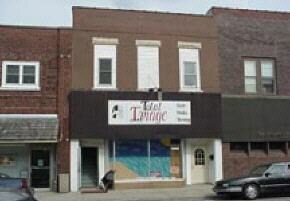
Property Record
11 N Main St, Villa Grove, IL 61956
NEARBY LISTINGS FOR SALE OR LEASE
-
-
View all Villa Grove listings for sale on LoopNet.com
Property Detail
11 N Main St
04-03-10-215-004
Johnstons Addn
Storebuilding
JOHNSTONS ADDN LOT 18 BLK 16
AE
Douglas
17041C0181D
Illinois
2024
18
2024
0.07 AC
952100
Effingham/Central Illinois Area
4,566 SF
Other Market Areas
DEMOGRAPHICS near 11 N Main St
1 Mile
3 Mile
5 Mile
2024 Total Population
2,448
2,676
3,707
2029 Population
2,457
2,685
3,729
Pop Growth 2024-2029
+ 0.37%
+ 0.34%
+ 0.59%
Average Age
40
40
41
2024 Total Households
1,013
1,107
1,543
HH Growth 2024-2029
+ 0.20%
+ 0.18%
+ 0.45%
Median Household Inc
$59,867
$60,413
$64,186
Avg Household Size
2.40
2.40
2.40
2024 Avg HH Vehicles
2.00
2.00
2.00
Median Home Value
$101,534
$103,511
$127,215
Median Year Built
1961
1961
1967
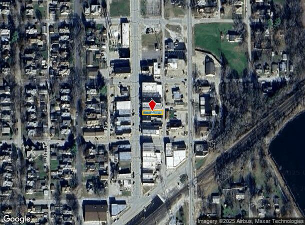
Nearby Places
Map Layers
Map Styles
 Street
 Aerial
- Restaurants
- Banks
- Shops
- Fitness
- Groceries
PUBLIC TRANSPORTATION
AIRPORT
University of Illinois/Willard
DRIVE
WALK
Distance
University of Illinois/Willard
40 min
20.3 mi
Nearby Properties
Address
Land Use
TOTAL SIZE
Lot Size
Zoning
Address
Land Use
TOTAL SIZE
Lot Size
Zoning
Address
Land Use
TOTAL SIZE
Lot Size
Zoning
14,513 SF
4.29 AC
Address
Land Use
TOTAL SIZE
Lot Size
Zoning
2,496 SF
2.50 AC
Address
Land Use
TOTAL SIZE
Lot Size
Zoning
2,206 SF
26.44 AC
Address
Land Use
TOTAL SIZE
Lot Size
Zoning
2,760 SF
0.65 AC
Address
Land Use
TOTAL SIZE
Lot Size
Zoning
154.70 AC
Address
Land Use
TOTAL SIZE
Lot Size
Zoning
6,300 SF
0.19 AC
Address
Land Use
TOTAL SIZE
Lot Size
Zoning
25,146 SF
0.41 AC
Address
Land Use
TOTAL SIZE
Lot Size
Zoning
12,832 SF
0.23 AC
Address
Land Use
TOTAL SIZE
Lot Size
Zoning
Address
Land Use
TOTAL SIZE
Lot Size
Zoning
2,697 SF
0.40 AC
Address
Land Use
TOTAL SIZE
Lot Size
Zoning
Address
Land Use
TOTAL SIZE
Lot Size
Zoning
8,500 SF
0.21 AC
Address
Land Use
TOTAL SIZE
Lot Size
Zoning
8,496 SF
0.11 AC
Address
Land Use
TOTAL SIZE
Lot Size
Zoning
5,200 SF
1.58 AC
Address
Land Use
TOTAL SIZE
Lot Size
Zoning
7,848 SF
2.73 AC
Address
Land Use
TOTAL SIZE
Lot Size
Zoning
1,980 SF
2.17 AC
Address
Land Use
TOTAL SIZE
Lot Size
Zoning
8,500 SF
1.50 AC
Address
Land Use
TOTAL SIZE
Lot Size
Zoning
3,432 SF
0.22 AC
Address
Land Use
TOTAL SIZE
Lot Size
Zoning
1,804 SF
0.28 AC
Address
Land Use
TOTAL SIZE
Lot Size
Zoning
5,812 SF
0.14 AC
Address
Land Use
TOTAL SIZE
Lot Size
Zoning
5,254 SF
0.49 AC
Address
Land Use
TOTAL SIZE
Lot Size
Zoning
3,085 SF
0.16 AC
Address
Land Use
TOTAL SIZE
Lot Size
Zoning
6,970 SF
0.14 AC
Address
Land Use
TOTAL SIZE
Lot Size
Zoning
3,262 SF
0.28 AC
Address
Land Use
TOTAL SIZE
Lot Size
Zoning
7,798 SF
0.12 AC
Address
Land Use
TOTAL SIZE
Lot Size
Zoning
5,088 SF
3.70 AC
Address
Land Use
TOTAL SIZE
Lot Size
Zoning
4,270 SF
0.07 AC
Address
Land Use
TOTAL SIZE
Lot Size
Zoning
6,300 SF
0.10 AC
The World's #1 Commercial Real Estate Marketplace
Connect with us
© 2026 CoStar Group
The information above has been obtained from sources believed reliable. While we do not doubt its accuracy we have not verified it and make no guarantee, warranty or representation about it. It is your responsibility to independently confirm its accuracy and completeness. Any projections, opinions, assumptions, or estimates used are for example only and do not represent the current or future performance of the property. The value of this transaction to you depends on tax and other factors which should be evaluated by your tax, financial, and legal advisors. You and your advisors should conduct a careful, independent investigation of the property to determine to your satisfaction the suitability of the property for your needs.