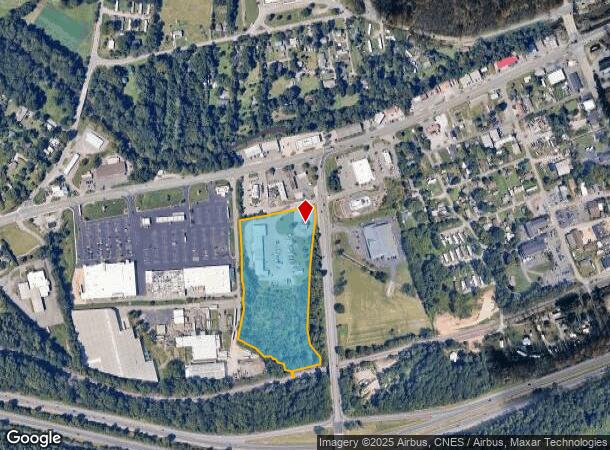
Property Record
11 Patton Cove Rd, Swannanoa, NC 28778
NEARBY LISTINGS FOR SALE OR LEASE
-
-
View all Swannanoa listings for sale on LoopNet.com
Property Detail
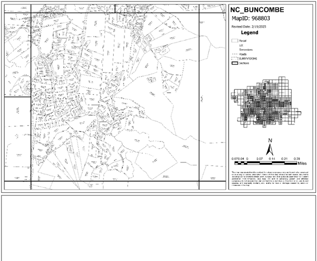
11 Patton Cove Rd
9688-89-2800-00000
The Meadows
Storebuilding
SUBDIV: BLOCK: LOT: SECTION: PLAT: 0146-0002
X
Buncombe
3700968800J
North Carolina
2024
8.94 AC
2025
Buncombe County
003002
Asheville
20,615 SF
Asheville, NC
DEMOGRAPHICS near 11 Patton Cove Rd
1 Mile
3 Mile
5 Mile
2024 Total Population
3,448
12,417
34,168
2029 Population
3,766
13,512
37,071
Pop Growth 2024-2029
+ 9.22%
+ 8.82%
+ 8.50%
Average Age
43
44
46
2024 Total Households
1,421
5,048
14,602
HH Growth 2024-2029
+ 8.59%
+ 8.28%
+ 7.84%
Median Household Inc
$71,387
$71,481
$71,692
Avg Household Size
2.30
2.30
2.20
2024 Avg HH Vehicles
2.00
2.00
2.00
Median Home Value
$316,414
$355,833
$399,062
Median Year Built
1985
1986
1990
Nearby Places
Map Layers
Map Styles
 Street
 Aerial
- Restaurants
- Banks
- Shops
- Fitness
- Groceries
PUBLIC TRANSPORTATION
AIRPORT
Asheville Regional
DRIVE
WALK
Distance
Asheville Regional
27 min
17.2 mi
Nearby Properties
Address
Land Use
TOTAL SIZE
Lot Size
Zoning
Address
Land Use
TOTAL SIZE
Lot Size
Zoning
300,000 SF
51.82 AC
PS
Address
Land Use
TOTAL SIZE
Lot Size
Zoning
192,232 SF
119.64 AC
OI-6
Address
Land Use
TOTAL SIZE
Lot Size
Zoning
323,429 SF
1,005.50 AC
PS
Address
Land Use
TOTAL SIZE
Lot Size
Zoning
208,084 SF
156.33 AC
PS
Address
Land Use
TOTAL SIZE
Lot Size
Zoning
93,360 SF
12.51 AC
PS
Address
Land Use
TOTAL SIZE
Lot Size
Zoning
44,450 SF
8.97 AC
PS
Address
Land Use
TOTAL SIZE
Lot Size
Zoning
1,262 SF
3,958.36 AC
OU
Address
Land Use
TOTAL SIZE
Lot Size
Zoning
771,179 SF
73.04 AC
LI-8
Address
Land Use
TOTAL SIZE
Lot Size
Zoning
492,052 SF
22.50 AC
EMP
Address
Land Use
TOTAL SIZE
Lot Size
Zoning
56,352 SF
48.90 AC
PS
Address
Land Use
TOTAL SIZE
Lot Size
Zoning
37,471 SF
7.56 AC
OI-6
Address
Land Use
TOTAL SIZE
Lot Size
Zoning
38.41 AC
EMP
Address
Land Use
TOTAL SIZE
Lot Size
Zoning
68,648 SF
7.87 AC
CS
Address
Land Use
TOTAL SIZE
Lot Size
Zoning
165,852 SF
14.02 AC
HI-0
Address
Land Use
TOTAL SIZE
Lot Size
Zoning
35,199 SF
3 AC
CS
Address
Land Use
TOTAL SIZE
Lot Size
Zoning
27,840 SF
4.29 AC
NS
Address
Land Use
TOTAL SIZE
Lot Size
Zoning
213,584 SF
37.91 AC
EMP
Address
Land Use
TOTAL SIZE
Lot Size
Zoning
28,893 SF
3.61 AC
R-1
Address
Land Use
TOTAL SIZE
Lot Size
Zoning
152,109 SF
6.02 AC
CS
Address
Land Use
TOTAL SIZE
Lot Size
Zoning
33,722 SF
8.80 AC
CS
Address
Land Use
TOTAL SIZE
Lot Size
Zoning
47,890 SF
7.10 AC
HI-0
Address
Land Use
TOTAL SIZE
Lot Size
Zoning
17,507 SF
1.81 AC
R-3
Address
Land Use
TOTAL SIZE
Lot Size
Zoning
30,374 SF
3.31 AC
CS
Address
Land Use
TOTAL SIZE
Lot Size
Zoning
38,043 SF
2.33 AC
NS
Address
Land Use
TOTAL SIZE
Lot Size
Zoning
147,361 SF
22.77 AC
HI-0
Address
Land Use
TOTAL SIZE
Lot Size
Zoning
13,260 SF
1.87 AC
CS
Address
Land Use
TOTAL SIZE
Lot Size
Zoning
7,941 SF
3.24 AC
NS
Address
Land Use
TOTAL SIZE
Lot Size
Zoning
31,830 SF
3.99 AC
CS
Address
Land Use
TOTAL SIZE
Lot Size
Zoning
13,651 SF
2.76 AC
R-3
Address
Land Use
TOTAL SIZE
Lot Size
Zoning
29,441 SF
5.93 AC
CS
The World's #1 Commercial Real Estate Marketplace
Connect with us
© 2025 CoStar Group
The information above has been obtained from sources believed reliable. While we do not doubt its accuracy we have not verified it and make no guarantee, warranty or representation about it. It is your responsibility to independently confirm its accuracy and completeness. Any projections, opinions, assumptions, or estimates used are for example only and do not represent the current or future performance of the property. The value of this transaction to you depends on tax and other factors which should be evaluated by your tax, financial, and legal advisors. You and your advisors should conduct a careful, independent investigation of the property to determine to your satisfaction the suitability of the property for your needs.