Property Record
11 Peekskill Rd, Cold Spring, NY 10516
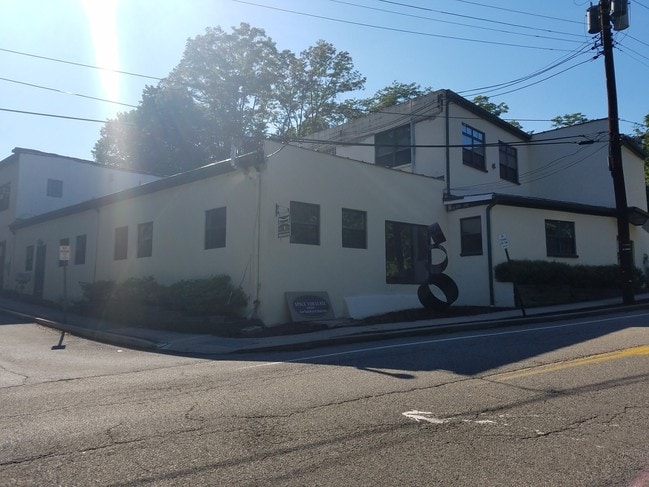

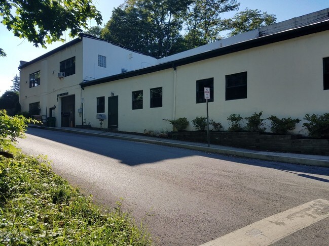
Property Detail
11 Peekskill Rd
372603-038-017-0002-006-000-0000
LAND & COMMERCIAL BLDG
Industrialgeneral
Putnam
R10
New York
B and X Area of moderate flood hazard, usually the area between the limits of the 100-year and 500-year floods.
6.000
2024
0.51 AC
2024
Carmel
010700
Westchester/So Connecticut
14,154 SF
New York-Jersey City-White Plains, NY-NJ
NEARBY LISTINGS FOR SALE OR LEASE
-
-
View all Cold Spring listings for lease on LoopNet.com
DEMOGRAPHICS near 11 Peekskill Rd
1 mile
3 mile
5 mile
2025 Total Population
2,943
10,353
27,789
2030 Population
2,978
10,584
28,376
Pop Growth 2025-2030
+ 1.19%
+ 2.23%
+ 2.11%
Average Age
46
35
39
2025 Total Households
1,290
2,698
9,204
HH Growth 2025-2030
+ 1.32%
+ 2.45%
+ 2.27%
Median Household Inc
$117,069
$133,601
$118,664
Avg Household Size
2.30
2.70
2.50
2025 Avg HH Vehicles
1.00
2.00
2.00
Median Home Value
$651,304
$697,534
$510,893
Median Year Built
1950
1969
1961
Nearby Places
Map Layers
Map Styles
 Street
 Aerial
Transit
 Traffic
 Biking
Places
Listings with unknown addresses are not visible on the map
- Restaurants
- Banks
- Shops
- Fitness
- Groceries
PUBLIC TRANSPORTATION
COMMUTER RAIL
Cold Spring Station (Hudson Line - Metro-North Commuter Railroad Company (Metro-North))
Drive
Walk
Distance
Cold Spring Station (Hudson Line - Metro-North Commuter Railroad Company (Metro-North))
4 min
1.3 mi
Breakneck Ridge Station (Hudson Line - Metro-North Commuter Railroad Company (Metro-North))
Drive
Walk
Distance
Breakneck Ridge Station (Hudson Line - Metro-North Commuter Railroad Company (Metro-North))
5 min
3.3 mi
AIRPORT
New York Stewart International
Drive
Walk
Distance
New York Stewart International
34 min
18.9 mi
Westchester County
Drive
Walk
Distance
Westchester County
57 min
41.9 mi
Freight Ports
NY - Red Hook Container Terminal
Drive
Walk
Distance
NY - Red Hook Container Terminal
93 min
65.0 mi
SALE & LEASE HISTORY
LISTING DATE
SALE/LEASE

Sep 25, 2016
For Lease
Nearby Properties
Address
Land Use
TOTAL SIZE
Lot Size
Zoning
Address
Land Use
TOTAL SIZE
Lot Size
Zoning
119,474 SF
214.27 AC
R80
Address
Land Use
TOTAL SIZE
Lot Size
Zoning
100,369 SF
11.96 AC
R10
Address
Land Use
TOTAL SIZE
Lot Size
Zoning
73,224 SF
464.99 AC
R80
Address
Land Use
TOTAL SIZE
Lot Size
Zoning
42,411 SF
5.17 AC
R10
Address
Land Use
TOTAL SIZE
Lot Size
Zoning
Address
Land Use
TOTAL SIZE
Lot Size
Zoning
2.07 AC
R120
Address
Land Use
TOTAL SIZE
Lot Size
Zoning
40,796 SF
125.03 AC
R80
Address
Land Use
TOTAL SIZE
Lot Size
Zoning
44,052 SF
23.97 AC
R80
Address
Land Use
TOTAL SIZE
Lot Size
Zoning
12,747 SF
35.73 AC
R80
Address
Land Use
TOTAL SIZE
Lot Size
Zoning
76.06 AC
PI
Address
Land Use
TOTAL SIZE
Lot Size
Zoning
Address
Land Use
TOTAL SIZE
Lot Size
Zoning
477.17 AC
R4A
Address
Land Use
TOTAL SIZE
Lot Size
Zoning
324 AC
R80
Address
Land Use
TOTAL SIZE
Lot Size
Zoning
21,120 SF
43.91 AC
R80
Address
Land Use
TOTAL SIZE
Lot Size
Zoning
44.70 AC
02
Address
Land Use
TOTAL SIZE
Lot Size
Zoning
39,971 SF
10.39 AC
R10
Address
Land Use
TOTAL SIZE
Lot Size
Zoning
19,474 SF
9.39 AC
R40
Address
Land Use
TOTAL SIZE
Lot Size
Zoning
Address
Land Use
TOTAL SIZE
Lot Size
Zoning
11,480 SF
10.84 AC
R40
Address
Land Use
TOTAL SIZE
Lot Size
Zoning
29,176 SF
66.77 AC
R80
Address
Land Use
TOTAL SIZE
Lot Size
Zoning
Address
Land Use
TOTAL SIZE
Lot Size
Zoning
21,729 SF
7.32 AC
B1
Address
Land Use
TOTAL SIZE
Lot Size
Zoning
48,758 SF
3.51 AC
R10
Address
Land Use
TOTAL SIZE
Lot Size
Zoning
19,232 SF
0.52 AC
R10
Address
Land Use
TOTAL SIZE
Lot Size
Zoning
13,814 SF
2.94 AC
R10
Address
Land Use
TOTAL SIZE
Lot Size
Zoning
16,586 SF
1.88 AC
R10
Address
Land Use
TOTAL SIZE
Lot Size
Zoning
85.75 AC
I
Address
Land Use
TOTAL SIZE
Lot Size
Zoning
14,904 SF
1.01 AC
R10
Address
Land Use
TOTAL SIZE
Lot Size
Zoning
293.80 AC
The World's #1 Commercial Real Estate Marketplace
Connect with us
© 2026 CoStar Group
The information above has been obtained from sources believed reliable. While we do not doubt its accuracy we have not verified it and make no guarantee, warranty or representation about it. It is your responsibility to independently confirm its accuracy and completeness. Any projections, opinions, assumptions, or estimates used are for example only and do not represent the current or future performance of the property. The value of this transaction to you depends on tax and other factors which should be evaluated by your tax, financial, and legal advisors. You and your advisors should conduct a careful, independent investigation of the property to determine to your satisfaction the suitability of the property for your needs.