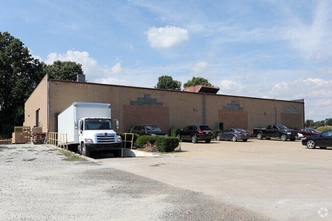
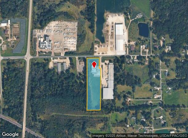
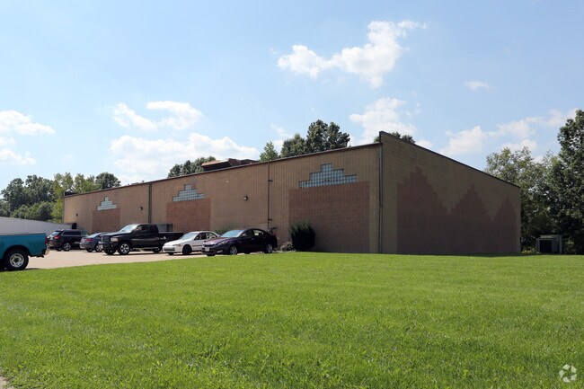
Property Record
11 Pipestone Rd, Rittman, OH 44270
NEARBY LISTINGS FOR SALE OR LEASE
Property Detail
11 Pipestone Rd
Wooster, OH
Simpson
60-00021-000
LOT 2847 SIMPSON ALT 1 5.893A MP 50 ST VA CD 3030
Manufacturinglight
Wayne
X
Ohio
39169C0107E
2847
2024
5.89 AC
2024
Ohio North Area
002902
Other Market Areas
12,417 SF
DEMOGRAPHICS near 11 Pipestone Rd
1 Mile
3 Mile
5 Mile
2024 Total Population
467
12,223
38,731
2029 Population
467
12,383
39,220
Pop Growth 2024-2029
0.00%
+ 1.31%
+ 1.26%
Average Age
43
42
41
2024 Total Households
181
4,868
15,307
HH Growth 2024-2029
(0.55%)
+ 1.19%
+ 1.18%
Median Household Inc
$77,232
$61,611
$69,527
Avg Household Size
2.50
2.40
2.50
2024 Avg HH Vehicles
3.00
2.00
2.00
Median Home Value
$330,328
$184,626
$188,012
Median Year Built
1982
1971
1971
Nearby Places
Map Layers
Map Styles
 Street
 Aerial
- Restaurants
- Banks
- Shops
- Fitness
- Groceries
PUBLIC TRANSPORTATION
AIRPORT
Akron-Canton Regional
DRIVE
WALK
Distance
Akron-Canton Regional
36 min
28.5 mi
Freight Ports
Port of Toledo
DRIVE
WALK
Distance
Port of Toledo
166 min
132.8 mi
Nearby Properties
Address
Land Use
TOTAL SIZE
Lot Size
Zoning
Address
Land Use
TOTAL SIZE
Lot Size
Zoning
3,450 SF
43.53 AC
PSM
Address
Land Use
TOTAL SIZE
Lot Size
Zoning
2,584 SF
12.89 AC
Address
Land Use
TOTAL SIZE
Lot Size
Zoning
38,794 SF
40 AC
Address
Land Use
TOTAL SIZE
Lot Size
Zoning
51,416 SF
15.13 AC
Address
Land Use
TOTAL SIZE
Lot Size
Zoning
6,573 SF
22.01 AC
Address
Land Use
TOTAL SIZE
Lot Size
Zoning
90,267 SF
10.91 AC
Address
Land Use
TOTAL SIZE
Lot Size
Zoning
47,784 SF
28.30 AC
Address
Land Use
TOTAL SIZE
Lot Size
Zoning
125,060 SF
12.27 AC
Address
Land Use
TOTAL SIZE
Lot Size
Zoning
106,929 SF
13.79 AC
Address
Land Use
TOTAL SIZE
Lot Size
Zoning
184,237 SF
22.64 AC
Address
Land Use
TOTAL SIZE
Lot Size
Zoning
17,879 SF
7.01 AC
Address
Land Use
TOTAL SIZE
Lot Size
Zoning
31,075 SF
3.17 AC
PSM
Address
Land Use
TOTAL SIZE
Lot Size
Zoning
14.21 AC
Address
Land Use
TOTAL SIZE
Lot Size
Zoning
16,722 SF
18.17 AC
Address
Land Use
TOTAL SIZE
Lot Size
Zoning
20,767 SF
9.35 AC
Address
Land Use
TOTAL SIZE
Lot Size
Zoning
50,868 SF
7.71 AC
Address
Land Use
TOTAL SIZE
Lot Size
Zoning
13,980 SF
2.91 AC
PSM
Address
Land Use
TOTAL SIZE
Lot Size
Zoning
20,000 SF
3.60 AC
M3
Address
Land Use
TOTAL SIZE
Lot Size
Zoning
31,800 SF
6.42 AC
M3
Address
Land Use
TOTAL SIZE
Lot Size
Zoning
5,880 SF
4.84 AC
Address
Land Use
TOTAL SIZE
Lot Size
Zoning
27.84 AC
M2
Address
Land Use
TOTAL SIZE
Lot Size
Zoning
15,240 SF
2.96 AC
Address
Land Use
TOTAL SIZE
Lot Size
Zoning
35,340 SF
14.32 AC
Address
Land Use
TOTAL SIZE
Lot Size
Zoning
31,202 SF
11.08 AC
Address
Land Use
TOTAL SIZE
Lot Size
Zoning
34,848 SF
3.76 AC
Address
Land Use
TOTAL SIZE
Lot Size
Zoning
15,582 SF
7.70 AC
Address
Land Use
TOTAL SIZE
Lot Size
Zoning
4,000 SF
7.24 AC
Address
Land Use
TOTAL SIZE
Lot Size
Zoning
45,216 SF
0.77 AC
R3
Address
Land Use
TOTAL SIZE
Lot Size
Zoning
37,766 SF
6.33 AC
C2
Address
Land Use
TOTAL SIZE
Lot Size
Zoning
19,092 SF
3.68 AC
C1
The World's #1 Commercial Real Estate Marketplace
Connect with us
© 2025 CoStar Group
The information above has been obtained from sources believed reliable. While we do not doubt its accuracy we have not verified it and make no guarantee, warranty or representation about it. It is your responsibility to independently confirm its accuracy and completeness. Any projections, opinions, assumptions, or estimates used are for example only and do not represent the current or future performance of the property. The value of this transaction to you depends on tax and other factors which should be evaluated by your tax, financial, and legal advisors. You and your advisors should conduct a careful, independent investigation of the property to determine to your satisfaction the suitability of the property for your needs.