Property Record
11 Randolph St, Enfield, CT 06082
NEARBY LISTINGS FOR SALE OR LEASE
-
-
View all Enfield listings for sale on LoopNet.com
Property Detail
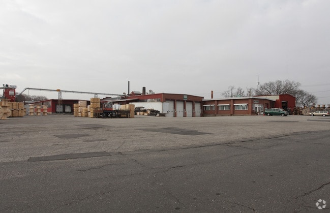
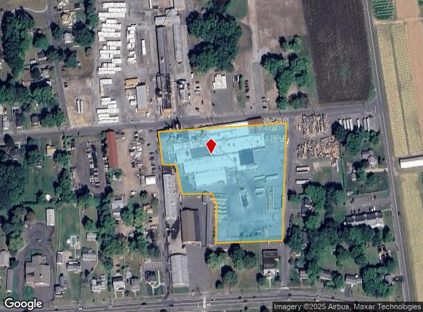
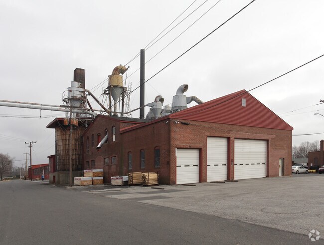
11 Randolph St
ENFI-000092-000000-000047
Hartford
Industrialgeneral
Connecticut
X
47
09003C0232F
4.51 AC
2025
Enfield
2025
Hartford
480800
Hartford-West Hartford-East Hartford, CT
79,075 SF
DEMOGRAPHICS near 11 Randolph St
1 Mile
3 Mile
5 Mile
2024 Total Population
3,261
24,142
70,935
2029 Population
3,246
23,967
70,547
Pop Growth 2024-2029
(0.46%)
(0.72%)
(0.55%)
Average Age
44
43
43
2024 Total Households
1,294
9,255
26,711
HH Growth 2024-2029
(0.77%)
(1.06%)
(0.75%)
Median Household Inc
$93,699
$97,383
$94,920
Avg Household Size
2.30
2.40
2.40
2024 Avg HH Vehicles
2.00
2.00
2.00
Median Home Value
$232,067
$235,138
$263,865
Median Year Built
1962
1965
1965
Nearby Places
Map Layers
Map Styles
 Street
 Aerial
- Restaurants
- Banks
- Shops
- Fitness
- Groceries
PUBLIC TRANSPORTATION
AIRPORT
Bradley International
DRIVE
WALK
Distance
Bradley International
25 min
11.2 mi
Freight Ports
Port of New Haven
DRIVE
WALK
Distance
Port of New Haven
78 min
59.7 mi
Nearby Properties
Address
Land Use
TOTAL SIZE
Lot Size
Zoning
Address
Land Use
TOTAL SIZE
Lot Size
Zoning
750,000 SF
405 AC
A-1
Address
Land Use
TOTAL SIZE
Lot Size
Zoning
226,545 SF
14 AC
A-1
Address
Land Use
TOTAL SIZE
Lot Size
Zoning
370.78 AC
R88
Address
Land Use
TOTAL SIZE
Lot Size
Zoning
283.30 AC
R88
Address
Land Use
TOTAL SIZE
Lot Size
Zoning
166,268 SF
36.70 AC
R44
Address
Land Use
TOTAL SIZE
Lot Size
Zoning
500,000 SF
71.20 AC
I-1
Address
Land Use
TOTAL SIZE
Lot Size
Zoning
201,978 SF
53.95 AC
R88
Address
Land Use
TOTAL SIZE
Lot Size
Zoning
121.07 AC
I-1
Address
Land Use
TOTAL SIZE
Lot Size
Zoning
32.97 AC
BR
Address
Land Use
TOTAL SIZE
Lot Size
Zoning
32.44 AC
BR
Address
Land Use
TOTAL SIZE
Lot Size
Zoning
49.16 AC
I-1
Address
Land Use
TOTAL SIZE
Lot Size
Zoning
319,054 SF
30.02 AC
I-P
Address
Land Use
TOTAL SIZE
Lot Size
Zoning
36.97 AC
I-1
Address
Land Use
TOTAL SIZE
Lot Size
Zoning
211,256 SF
41.58 AC
R33
Address
Land Use
TOTAL SIZE
Lot Size
Zoning
121 AC
A-1
Address
Land Use
TOTAL SIZE
Lot Size
Zoning
24.92 AC
BL
Address
Land Use
TOTAL SIZE
Lot Size
Zoning
13.87 AC
BR
Address
Land Use
TOTAL SIZE
Lot Size
Zoning
13.78 AC
BR
Address
Land Use
TOTAL SIZE
Lot Size
Zoning
1.87 AC
BP
Address
Land Use
TOTAL SIZE
Lot Size
Zoning
19.36 AC
BR
Address
Land Use
TOTAL SIZE
Lot Size
Zoning
144,625 SF
19 AC
BR
Address
Land Use
TOTAL SIZE
Lot Size
Zoning
17.34 AC
R44
Address
Land Use
TOTAL SIZE
Lot Size
Zoning
54.05 AC
I-1
Address
Land Use
TOTAL SIZE
Lot Size
Zoning
21.97 AC
I-1
Address
Land Use
TOTAL SIZE
Lot Size
Zoning
106,719 SF
3.76 AC
BR
Address
Land Use
TOTAL SIZE
Lot Size
Zoning
170,863 SF
18.38 AC
I-1
Address
Land Use
TOTAL SIZE
Lot Size
Zoning
125,406 SF
7.54 AC
BR
Address
Land Use
TOTAL SIZE
Lot Size
Zoning
15.91 AC
R44
Address
Land Use
TOTAL SIZE
Lot Size
Zoning
48,956 SF
4.78 AC
I-1
Address
Land Use
TOTAL SIZE
Lot Size
Zoning
104,111 SF
11.16 AC
I-1
The World's #1 Commercial Real Estate Marketplace
Connect with us
© 2026 CoStar Group
The information above has been obtained from sources believed reliable. While we do not doubt its accuracy we have not verified it and make no guarantee, warranty or representation about it. It is your responsibility to independently confirm its accuracy and completeness. Any projections, opinions, assumptions, or estimates used are for example only and do not represent the current or future performance of the property. The value of this transaction to you depends on tax and other factors which should be evaluated by your tax, financial, and legal advisors. You and your advisors should conduct a careful, independent investigation of the property to determine to your satisfaction the suitability of the property for your needs.