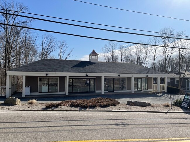
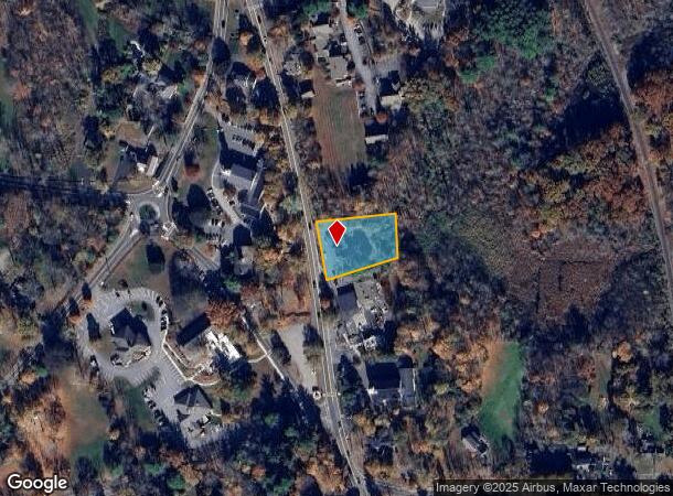
Property Record
11 S Main St, Sherborn, MA 01770

Current Lease Availabilities
NEARBY LISTINGS FOR SALE OR LEASE
-
-
View all Sherborn listings for lease on LoopNet.com
Property Detail
11 S Main St
SHER-000011-000000-000048
Middlesex
Storebuilding
Massachusetts
X
48
25017C0651F
0.60 AC
2025
Framingham/Natick
2025
Boston
386100
Boston-Cambridge-Newton, MA-NH
5,075 SF
DEMOGRAPHICS near 11 S Main St
1 mile
3 mile
5 mile
2024 Total Population
1,337
23,938
110,398
2029 Population
1,324
23,868
109,579
Pop Growth 2024-2029
(0.97%)
(0.29%)
(0.74%)
Average Age
41
40
40
2024 Total Households
454
9,142
41,798
HH Growth 2024-2029
(0.88%)
(0.50%)
(0.87%)
Median Household Inc
$223,047
$107,968
$111,409
Avg Household Size
2.90
2.60
2.60
2024 Avg HH Vehicles
2.00
2.00
2.00
Median Home Value
$858,735
$723,675
$655,674
Median Year Built
1968
1973
1967
Nearby Places
Map Layers
Map Styles
 Street
 Aerial
Transit
 Traffic
 Biking
Places
Listings with unknown addresses are not visible on the map
- Restaurants
- Banks
- Shops
- Fitness
- Groceries
PUBLIC TRANSPORTATION
COMMUTER RAIL
Natick (Framingham/Worcester Line - Massachusetts Bay Transportation Authority Commuter Rail (Purple Line))
Drive
Walk
Distance
Natick (Framingham/Worcester Line - Massachusetts Bay Transportation Authority Commuter Rail (Purple Line))
7 min
3.6 mi
West Natick (Framingham/Worcester Line - Massachusetts Bay Transportation Authority Commuter Rail (Purple Line))
Drive
Walk
Distance
West Natick (Framingham/Worcester Line - Massachusetts Bay Transportation Authority Commuter Rail (Purple Line))
9 min
4.1 mi
AIRPORT
General Edward Lawrence Logan International
Drive
Walk
Distance
General Edward Lawrence Logan International
38 min
23.8 mi
Worcester Regional
Drive
Walk
Distance
Worcester Regional
55 min
30.5 mi
Freight Ports
Port of Boston
Drive
Walk
Distance
Port of Boston
37 min
22.2 mi
Nearby Properties
Address
Land Use
TOTAL SIZE
Lot Size
Zoning
Address
Land Use
TOTAL SIZE
Lot Size
Zoning
188,746 SF
46.90 AC
RSA
Address
Land Use
TOTAL SIZE
Lot Size
Zoning
315,055 SF
40.38 AC
G
Address
Land Use
TOTAL SIZE
Lot Size
Zoning
20,704 SF
13.36 AC
PCD
Address
Land Use
TOTAL SIZE
Lot Size
Zoning
36.60 AC
R2
Address
Land Use
TOTAL SIZE
Lot Size
Zoning
108.84 AC
M
Address
Land Use
TOTAL SIZE
Lot Size
Zoning
251,366 SF
14.42 AC
G
Address
Land Use
TOTAL SIZE
Lot Size
Zoning
140,695 SF
2.52 AC
G
Address
Land Use
TOTAL SIZE
Lot Size
Zoning
39,840 SF
17.20 AC
G
Address
Land Use
TOTAL SIZE
Lot Size
Zoning
75,224 SF
4.05 AC
I
Address
Land Use
TOTAL SIZE
Lot Size
Zoning
87.30 AC
A
Address
Land Use
TOTAL SIZE
Lot Size
Zoning
189.70 AC
RSB
Address
Land Use
TOTAL SIZE
Lot Size
Zoning
78.50 AC
R2
Address
Land Use
TOTAL SIZE
Lot Size
Zoning
237,660 SF
20.98 AC
I
Address
Land Use
TOTAL SIZE
Lot Size
Zoning
58,053 SF
22.07 AC
R4
Address
Land Use
TOTAL SIZE
Lot Size
Zoning
5.96 AC
M
Address
Land Use
TOTAL SIZE
Lot Size
Zoning
1,039 SF
3.31 AC
RM
Address
Land Use
TOTAL SIZE
Lot Size
Zoning
5,280 SF
8.92 AC
G
Address
Land Use
TOTAL SIZE
Lot Size
Zoning
9,032 SF
10 AC
RSA
Address
Land Use
TOTAL SIZE
Lot Size
Zoning
11.65 AC
R2
Address
Land Use
TOTAL SIZE
Lot Size
Zoning
52,288 SF
4.65 AC
RSA
Address
Land Use
TOTAL SIZE
Lot Size
Zoning
26,485 SF
65.37 AC
R4
Address
Land Use
TOTAL SIZE
Lot Size
Zoning
29,280 SF
0.74 AC
G
Address
Land Use
TOTAL SIZE
Lot Size
Zoning
59.97 AC
R2
Address
Land Use
TOTAL SIZE
Lot Size
Zoning
273.63 AC
RC
Address
Land Use
TOTAL SIZE
Lot Size
Zoning
54,432 SF
2.96 AC
DM
Address
Land Use
TOTAL SIZE
Lot Size
Zoning
113,516 SF
7.94 AC
I
Address
Land Use
TOTAL SIZE
Lot Size
Zoning
121.74 AC
R2
Address
Land Use
TOTAL SIZE
Lot Size
Zoning
35,542 SF
15.50 AC
RSA
Address
Land Use
TOTAL SIZE
Lot Size
Zoning
1.58 AC
M
Address
Land Use
TOTAL SIZE
Lot Size
Zoning
245 SF
74.22 AC
RSA
The World's #1 Commercial Real Estate Marketplace
Connect with us
© 2026 CoStar Group
The information above has been obtained from sources believed reliable. While we do not doubt its accuracy we have not verified it and make no guarantee, warranty or representation about it. It is your responsibility to independently confirm its accuracy and completeness. Any projections, opinions, assumptions, or estimates used are for example only and do not represent the current or future performance of the property. The value of this transaction to you depends on tax and other factors which should be evaluated by your tax, financial, and legal advisors. You and your advisors should conduct a careful, independent investigation of the property to determine to your satisfaction the suitability of the property for your needs.